Sunday, March 31, 2013

From 2012 to 2013, March Blows Hot, Then Cold

link to article


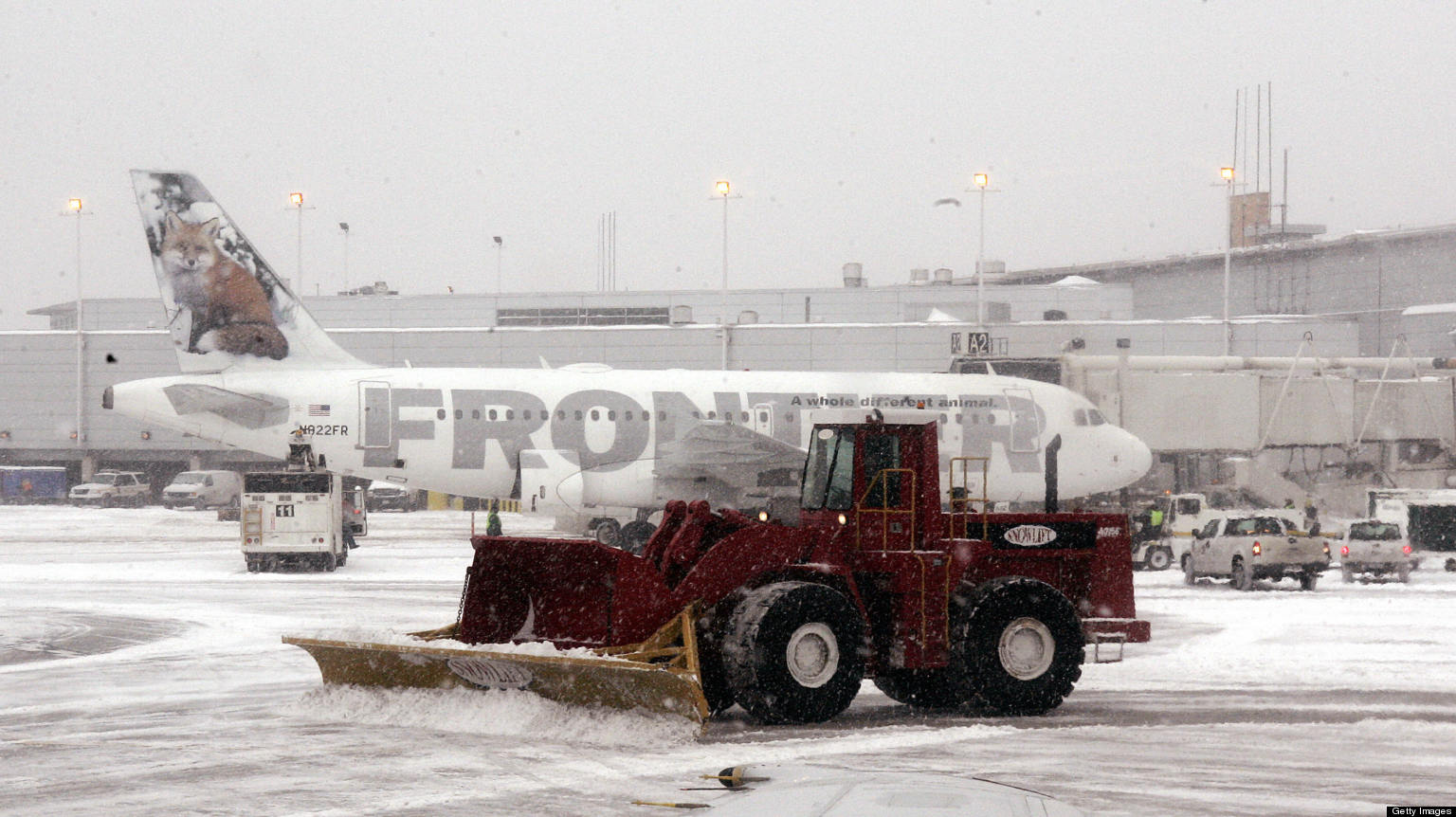
March is finally on its way out, but not before leaving its mark in the unusually cold and snowy weather that affected much of the U.S., Europe, and parts of Asia. The chilly weather has come courtesy of a stuck weather pattern that has repeatedly directed blasts of cold Arctic air southward, while leaving Greenland and northeastern Canada much warmer than average for this time of year. 
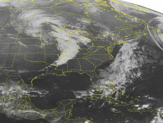
Think of the Arctic as the Northern Hemisphere’s refrigerator. The blocked weather pattern  which some scientists think may be tied to the rapid warming of the Arctic and the subsequent loss of sea ice cover  has opened the refrigerator door, causing cold air to spill out of the freezer that is the Far North and help develop winter storms in the northern mid-latitudes. One such storm occupied much of the Northern Atlantic on Thursday, stretching from just south of Greenland all the way east to Ireland and Spain.
The cold weather this month has been in stark contrast to last March, when an unprecedentedly long-lasting andintense early spring heat wave sent temperatures soaring into the 80s all the way to the U.S. border with Canada. 
The interactive graphic above shows a comparison between the temperature departures from average during March of 2013 (through March 28) and March 2012. 
One of the things to note is that although the extent of the warm weather last March corresponds well to the area affected by the cold this year, the magnitude of the warmth during the 2012 heat wave was far greater than the severity of this year’s cold weather. 
This can also be seen by examining the number and characteristics of the temperature records set during the warm March of 2012 and the cold March this year. 
In March 2012, the ratio of warm temperature records to cold temperature records was extraordinarily lopsided, at about 15 to 1. But in March 2013, cold temperature records are only beating warm records by about a 2-to-1 ratio, according to data from the National Climatic Data Center (NCDC) in Asheville, N.C.

Climate Change Will Harm Mekong Basin Harvests

link to article


LONDON – One of the most fertile areas of south east Asia, the Lower Mekong Basin, faces a bleak future from the impacts of climate change, according to a U.S.-funded study.
The lead author of the study, Dr. Jeremy Carew-Reid, says some of its findings are “very shocking.”
Hotter and wetter rainy seasons and more long-lasting dry seasons in Cambodia, Laos, Thailand and Vietnam will jeopardize the region’s reputation as one of the world’s major producers of crops on which hundreds of millions depend. Climate change will also have a profound economic impact in the region.
The fertility of the region around the Mekong will suffer due to a changing climate.
Credit: Thomas Schoch
“We’ve found that this region is going to experience climate extremes in temperature and rainfall beyond anything that we expected”, says Dr. Carew-Reid.
The Basin is known for its production of maize and rice, the two grains with the highest worldwide production levels. Rice provides more than a fifth of the calories consumed by humans. The study forecasts fundamental shifts in the kinds of crops that can be grown in parts of the Basin.
The USAID-funded Climate Change Adaptation and Impact Study for the Lower Mekong examines how changes in temperature and precipitation will affect growing conditions and yields for major crops including not only maize and rice but rubber, cassava, soya and coffee, and  how fisheries and livestock productivity will be affected.
There’s general international agreement that global average temperatures should if possible be prevented from rising more than 2°C above their pre-industrial level, although most climate scientists believe it’s now too late to stop temperatures rising further.
A global average rise of 2°C is expected to mean that parts of the tropics like the Mekong Basin will warm by between 4°C and 6°C by mid-century. The impacts will vary, but all the Lower Mekong countries are likely to see big changes in the suitability of land for important crops.

March 27 News: Melting Arctic Sea Ice Drives Extreme Weather, U.S Military Planning

link to article


Most of the Arctic sea ice that forms each year melts in the spring and summer, which affects global weather patterns and U.S. military planning. [NBC News]
“There are tremendous two-way and multiple interactions between the Arctic and the rest of the world,” retired Rear Adm. David Titley said during the teleconference organized by Climate Nexus, a group trying to raise awareness about climate change.
Experts tied the melting ice in the Arctic to the recent spate of stormy winter weather in parts of the U.S. and Europe. They also noted that the prospect of ice-free summers in the Arctic as soon as 2030 is already impacting international trade and U.S. Navy plans to protect Arctic resources.
The briefing was held the day after the National Snow and Ice Data Center (NSIDC) announced that the Arctic sea ice reached its maximum reach for the year on March 15, covering 5.84 million square miles. This is the sixth lowest maximum sea ice coverage in the 35-year satellite record.
Melting season starts: Arctic sea ice hit its maximum for the year, and it’s the 6th lowest on record. [Climate Central]
Yesterday the Obama Administration announced a plan to help wildlife adapt to the threats posed by climate change. [LA Times]
Vice Admiral Lee Gunn (ret.) is in Texas to explain how national security is threatened by climate change, and how naval bases are already being rebuilt due to sea level rise. [NPR Texas]
The governors of Oregon and Washington are imploring the White House to consider climate change when it looks at environmental impacts of coal export terminals. [The Hill]
New York State may be the first to tell bondholders that climate change is a risk to their investments. [Bloomberg]
The city of Melbourne, Australia, is now carbon-neutral by virtue of emissions reductions and offsets. [Climate Group]
A new study finds that if you add lignin (a worthless byproduct of corn/ethanol) to concrete, the concrete gets 32% stronger — allowing you to use less carbon-intensive cement. [EarthTechling]
Coral reefs in southern Florida have declined by 50 percent over the last twenty years. [Climate Adaptation]
Community solar will allow electricity-hungry Orlando residents to buy solar power for 13 cents a kw/h, guaranteed for 25 years. And the solar installation is over a parking lot! [EarthTechling]
They call it the “oil & gas industry” for a reason: the next CEO of the American Natural Gas Alliance comes from the American Petroleum Institute. [The Hill]
An aluminum-air battery, used as an emergency one-time backup for an electric car, could carry you 1,000 miles at once. [CleanTechnica]
Climate change is rewriting the world’s wine list, causing vinyards to consider importing grapes from warmer latitudes, and messing with the finesse of Languedoc. [Discovery]

As Scientists Predicted, Global Warming Continues

link to article

By Dr. Jeff Masters, via Weather Underground
One often hears the statement in the media that global warming stopped in 1998, or that there has been no global warming for the past 16 years. Why pick 16 years? Why not some nice round number like 20 years? Or better yet, 30 years, since the climate is generally defined as the average weather experienced over a period of 30 years or longer?
Temperatures at Earth’s surface undergo natural, decades-long warming and cooling trends, related to the La Niña/El Niño cycle and the 11-year sunspot cycle. The reason one often hears the year 1998 used as a base year to measure global temperature trends is that this is a cherry-picked year.
An extraordinarily powerful El Niño event that was the strongest on record brought about a temporary increase in surface ocean temperatures over a vast area of the tropical Pacific that year, helping boost global surface temperatures to the highest levels on record (global temperatures were warmer in both 2005 and 2010, but not by much.) But in the years from 2005 – 2012, La Niña events have been present for at least a portion of every single year, helping keep Earth’s surface relatively cool.
Thus, if one draws a straight-line fit of global surface temperatures from 1998 to 2012, a climate trend showing little global warming results. If one picks any year prior to 1998, or almost any year after 1998, a global warming trend does result. The choice of 1998 is a deliberate abuse of statistics in an attempt to manipulate people into drawing a false conclusion on global temperature trends. One of my favorite examples of this manipulation of statistics is shown an animated graph called “The Escalator”, created by skepticalscience.com (Figure 1).
Figure 1. Average of NASA’s GISS, NOAA”s NCDC, and the UK Met Office’s HadCRUT4 monthly global surface temperature departures from average, from January 1970 through November 2012 (blue), with linear trends applied to the time frames Jan ’70 – Oct ’77, Apr ’77 – Dec ’86, Sep ’87 – Nov ’96, Jun ’97 – Dec ’02, Nov ’02 – Nov ’12. Climate change skeptics like to emphasize the shorter term fluctuations in global temperatures (blue lines) and ignore the long-term climate trend (red line.) The global surface temperature trend from January 1970 through November 2012 (red line) is +0.16°C (+0.29°F) per decade. Image credit: skepticalscience.com.
Correcting for natural causes to find the human contribution to global temperature changes

Saturday, March 30, 2013

WEATHER: Severe storms weakening across metro

Severe weather mike map

These storms could develop quarter to golf ball-size hail.
Highest chances for rain will be over central Oklahoma.
We will dry out for the second half of Saturday.
Easter Sunday will be beautiful with mild temperatures and partly cloudy skies.
There is a slight chance for rain just southeast of OKC.
Enjoy it…wet and chilly conditions move in early next week with a powerful storm system.

Severe Storms into Tonight: Wichita to Dallas, Shreveport


Locally severe thunderstorms will continue to erupt from Kansas to northern Texas and Louisiana through tonight.
The thunderstorms will also graze western parts of Missouri and Arkansas before the danger zone centers on places from East Texas to Alabama on Easter Sunday.
With the strongest thunderstorms through tonight, the main threats will remain large hail, damaging wind gusts, blinding downpours and lightning.
An isolated tornado or two also threatens to touch down and cause destruction.

Weather official: Expect active tornado season for Kansas Read more here: http://www.kansascity.com/2013/03/30/4152500/weather-official-expect-active.html#storylink=cpy


“It certainly hasn’t been a terribly active tornado period anywhere in the U.S. during the last three months,” Jon Davies, a respected weather researcher and storm chaser, said in an e-mail response to questions.
But weather officials say 2013 figures to be much more active for tornadoes than last year, which was among the quietest on record.

Read more here: http://www.kansascity.com/2013/03/30/4152500/weather-official-expect-active.html#storylink=cpy

The Last Shot of Cold Weather


The Last Shot of Cold Weather... Snow and Severe Weather


I am starting to see a transition of the cold weather to one that more like early spring. 

The A.O is coming up, the N.A.O is going to positive and the P.N.A is going negative which all means a reversal of the weather pattern across the eastern part of the country. As I said before, it's a long and windy road getting there, but we will get there.
The next shot of cold weather is coming down the slide later this weekend into early next week. We have some severe storms ahead of that front across the southern Plains which can produce large hail and damaging wind gusts.
http://www.accuweather.com/en/weather-blogs/meteomadness/the-last-shot-of-cold-weathersnow-and-severe-weather/9098302

Friday, March 29, 2013

Powerful Atlantic Coast-to-Coast Storm Threatens Spring Break

An unusually large storm responsible for this past week’s record late March snow has moved over to the North Atlantic just in time for spring break.
The enormous storm, which stretches coast-to-coast from Newfoundland to Portugal, is not only overwhelming in size but very intense.  Its central pressure is 953 millibars, carrying the force of a Category 3 hurricane.
With some of the storm’s waves measuring as high as 30 to 40 feet, it has grown into a monster extending as far as the Caribbean since its original humble beginnings.
In the past two days, the storm has grown powerful enough to draw record low temperatures in the Southeast United States, including Florida and the Florida Keys.
From where it began in the Midwest to where it blanketed the Mid-Atlantic with snow, the massive storm is now in a pocket of Greenland and Eastern Canada cold air and the mild Gulf Stream air.  This disparity in temperature has enhanced the storm’s strength.
As it moves towards Western Europe, the strength of the storm has already began to weaken slightly.  Over the next few days, it will break up into several systems that will travel into Europe.  These particular storms are not expected to be unusually strong, as they approach Portugal by next Wednesday.

http://abcnews.go.com/blogs/headlines/2013/03/powerful-atlantic-coast-to-coast-storm-threatens-spring-break/

ht massive storm mi 130329 wblog Powerful Atlantic Coast to Coast Storm Threatens Spring Break

Coldest April Fool's Day in 20 Years: Chicago, Duluth

The arctic invasion headed to the Midwest early next week will lead to the coldest April Fool's Day in years, even decades for some.
This Easter weekend will start with high temperatures near or above normal across the Midwest, but will end with arctic air plunging into the Upper Midwest on Sunday.
A noticeably colder Monday then awaits the rest of the Midwest as the cold blast continues its journey to the south and east, eventually reaching the East and Gulf coasts by Wednesday (but not including the Florida Peninsula).
Highs on Monday throughout the Midwest will be held to the 30s north of the Ohio River with temperatures failing to crack the 30-degree mark from northern and eastern North Dakota to northern parts of Michigan.

Play video

http://www.accuweather.com/en/weather-news/coldest-april-fools-day-in-20/9111879

A Lamb-like Easter Weekend-Weather Wisdom with David Epstein

A Lamb-like Easter Weekend!

    The end of March is fast approaching and when it’s over, this month will go down in the record books as a cold and snowy one. The good news is the lamb will indeed lead us into April this year. You probably noticed a lot of clouds around the area the past couple of days and today will continue that trend. A weak bit of energy will rotate through the area during the day and this will produce periods of clouds with just the risk of a shower. Any rain that falls will be light and not last long.

The weekend is looking quite nice. When you get up Saturday there may be a few clouds, but the trend will be for increasing amounts of sunshine and mild temperatures. 

http://www.boston.com/news/weather/weather_wisdom/2013/03/a_lamb-like_easter_weekend.html


Thursday, March 28, 2013

cold april


Winter Weather
Winter Weather

No April Fools' Joke: Another Cold Blast

Chris Dolce Published: Mar 28, 2013, 10:45 AM EDT weather.com

Overlay

Given the timing, you would think we were playing a cruel April Fools' Day joke as we look at the forecast to start out next week.
A cold front will usher in yet another blast of late-season arctic air that will charge into the central and eastern states after a brief warmup to near-average temperatures over Easter weekend. Of course, this only piles on to the misery of what has been a frustrating cold March east of the Rockies.

volcanoes

That's No Bomb -- It's an Underwater Volcano (PHOTOS)

Sean Breslin Published: Mar 28, 2013, 8:04 AM EDT weather.com

An undersea volcano is seen erupting off the coast of Tonga, sending plumes of steam, ash and smoke hundreds of feet into the air on March 18, 2009. (Dana Stephenson/Getty Images)

Deep under the Pacific Ocean and along the Ring of Fire sits a volcano that suddenly came to life in March 2009.
The eruption captured by the images above occurred just miles off the coast of Tonga, a chain of islands north of New Zealand in the Pacific Ocean. They sit on a fault line that is extremely active, and when a 4.4-magnitude earthquake shook the islands in 2009, residents thought nothing of it.
News

Severe Threat Returns Starting Friday

Published: Mar 28, 2013, 0:26 PM EDT weather.com
Background

Friday's Outlook

Friday's Outlook
The next chance of severe thunderstorms will begin in the Southern Plains Friday, continuing into the Easter holiday weekend.
Background

Saturday's Outlook

Saturday's Outlook
While this doesn't appear to be a widespread outbreak, the risk of damaging winds, hail, and perhaps a couple tornadoes are possible
You can find more details on the severe thunderstorm and tornado risk, including the extended forecast, on our TOR:CON index page at this link.

Wednesday, March 27, 2013

Extreme Weather: The New Normal

A comparison of the extreme cold we've been having for what's meant to be Spring. March 2012 and March 2013 are at a drastic difference because 2012 set record highs while 2013's March is the coolest one we've had since 1999. This is only in the United States as well. The rest of the article covers how this drastic weather, right now, may be occurring and if it is the new normal. 

http://www.wjla.com/blogs/weather/2013/03/extreme-weather-the-new-normal--18422.html

Heat, Flood or Icy Cold, Extreme Weather Rages Worldwide

WORCESTER, England — Britons may remember 2012 as the year the weather spun off its rails in a chaotic concoction of drought, deluge and flooding, but the unpredictability of it all turns out to have been all too predictable: Around the world, extreme has become the new commonplace. Especially lately. China is enduring its coldest winter in nearly 30 years. Brazil is in the grip of a dreadful heat spell. Eastern Russia is so freezing — minus 50 degrees Fahrenheit, and counting — that the traffic lights recently stopped working in the city of Yakutsk.


http://www.nytimes.com/2013/01/11/science/earth/extreme-weather-grows-in-frequency-and-intensity-around-world.html?pagewanted=all&_r=0

Weather: 'It is supposed to be spring', says Met Office as more snow on the way


The country will experience a north-south divide over the next few days, with heavy persistent rain across the South bringing flood warnings, while other parts of the country brace themselves for a blanket of white.
Heavy snow is expected across northern and central parts of England, Northern Ireland, Scotland, and North Wales overnight tonight and into tomorrow.
Lower levels are likely to see around four inches (10cm) while on higher ground that could reach around 16 inches (40cm).
Even areas as far south as Birmingham and Peterborough could see just over 3 inches of snow (8cm) while forecasters have warned that the wintry showers could reach London by Saturday morning.
It is too early to predict how much snow may fall in the South East, but it is looking like there may be a covering, forecasters have said.


http://www.telegraph.co.uk/topics/weather/9945237/It-is-supposed-to-be-spring-says-Met-Office-as-more-snow-on-the-way.html


Sun's Activity To Peak This Year, Scientists Say

Mike Wall, SPACE.com Published: Mar 26, 2013, 4:53 PM EDT From our partners
Overlay

Massive Solar Eruption Captured by NASA

The sun should roar back to life sometime in 2013, producing its second activity peak in the last two years, scientists say.
(MORE: EXPLOSION from the Sun)
Our star has been surprisingly quiet since unleashing a flurry of flares and other eruptions toward the end of 2011. But this lull is likely the trough between two peaks that together constitute "solar maximum" for the sun's current 11-year activity cycle, researchers say.
NASA/Solar Dynamics Observatory/Getty Images
The largest solar flare in 5 years leapt from the sun in early March 2012.
"If you look back in history, many of the previous solar cycles don't have one hump, one maximum, but in fact have two," solar physicist C. Alex Young, of NASA's Goddard Space Flight Center in Greenbelt, Md., said last week during a NASA webcast called "Solar MAX Storm Warning: Effects on the Solar System."
"That's what we think is going to happen," Young added. "So we've reached one of those humps, and we think that eventually activity will pick back up and we'll see another hump — a double-humped solar maximum."

A Cold March: Seeing the Silver Lining

Published: Mar 27, 2013, 2:24 PM EDT weather.com
 
Overlay

So Where Is Spring Anyway..!?

Autoplay
On
Off
Smaller pollen counts. Slow-growing grass that requires less maintenance. More time spent close to families.
See, an extended winter isn't all bad!
Though plenty of people are pleading with Mother Nature to return the country to a state of spring -- when warmer temperatures fill the air and plants bloom for the long summer ahead -- not everyone is cursing in the groundhog's general direction. Check out how some have taken a positive approach, via social media, to the changing seasons (or lackthereof).

Tuesday, March 26, 2013

What spring? Snow snarls traffic, flights on U.S. East Coast


 March 25 (Reuters) - The first Monday of spring brought snow
instead of sunshine along the U.S. East Coast, snarling the morning commute in the densely populated stretch betweenWashington and New York.
 A storm that had dropped significant amounts of snow across
the Midwest over the weekend rolled across Ohio, Pennsylvania,
Virginia and New Jersey, bringing a slushy mix of snow and rain
that prompted school closings and contributed to traffic
accidents around the region.
The National Weather Service had winter storm warnings in
effect from Massachusetts to South Carolina, with as much as 10
inches (25 cm) recorded in mountainous parts of West Virginia
and up to a foot (30 cm) expected in Pittsburgh.

Website: http://www.chicagotribune.com/sns-rt-usa-weatherl2n0ch0dc-20130325,0,4326413.story

Late season storm could leave foot of snow in central Illinois


Just when we thought we were done with snow, forecasters say we can expect to see more of it Sunday and early Monday with central Illinois seeing as much as a foot.
We can thank a storm system that is moving along the southern high Plains states and southern Rockies, said Mark Ratzer, a meteorologist with the National Weather Service in Romeoville.The south suburbs, including the far south side of the city, could see between 2 and 4 inches of the white stuff. The northern suburbs could see only about 1 inch of snow, he said.

Website: http://articles.chicagotribune.com/2013-03-23/news/chi-late-season-snowstorm-could-leave-1foot-in-central-illinois-20130323_1_lake-effect-snow-snow-showers-storm-system

City ordered to pay decade-old snow removal bill


The City of Chicago has been ordered to reimburse the federal government about $6 million for emergency snow removal costs incurred more than a decade ago.
During two severe snow storms, one in 1999 and one in 2000, the city enlisted help from the Federal Emergency Management Agency to remove snow at O’Hare and Midway airports.
But on Thursday, U.S. District Judge Charles Norgle filed a ruling that sided with FEMA.

Website: http://www.chicagotribune.com/news/local/breaking/chi-city-ordered-to-pay-decadeold-snow-removal-bill-20130325,0,1413462.story

Northern hemisphere, melting ice.


sea ice
Melting sea ice has been blamed for the extreme weather hitting the northern hemisphere this past winter. According to climate scientists, massive snow storms like those that hit North America and Europe recently were directly related to shrinking sea ice levels in the Arctic. Satellite pictures showed the ice had reached its maximum around March 15, but was still the sixth lowest expanse on record. As the yearly sea ice melt season began, the National Snow and Ice Data Center (NSIDC) in Boulder, Colorado, said there were only about 5.7 million square miles.
link to full text! 
 http://www.france24.com/en/20130312-late-winter-snowstorm-batters-northwest-europe

Private firm could fill weather satellite gap

severe satellite


The looming gap in satellite coverage later this decade due to aging weather satellites has the federal government worried.


Within the next few years, some of the USA's aging weather satellites are predicted to deteriorate or fail, which could leave a gap in the data that forecasters use to predict weather.
But now, a private company — Bethesda, Md.-based PlanetIQ — is proposing to bridge that gap: PlanetIQ's solution includes launching a constellation of 12 small satellites in low-Earth orbit to collect weather data, which PlanetIQ says the federal government could access at less cost and risk than current government-funded efforts.
Anne Hale Miglarese, CEO of PlanetIQ, made this case before the U.S. House Appropriations Subcommittee on Commerce, Justice, Science and Related Agencies last Thursday. She said that using PlanetIQ's proposal would:
  • Improve weather forecast accuracy and warning lead times.
  • Mitigate the risk of harmful gaps in satellite data.
  • Relieve pressure on existing government satellite programs that are over-budget and behind schedule
Full Story : http://www.usatoday.com/story/weather/2013/03/25/weather-satellite-gap-private-company-planetiq/2018047/

Easter weekend travel troubles?


No major storms will affect the nation during the Easter weekend. However, there will be areas of unsettled weather in the form of clouds, showers, thunderstorms and even a bit of snow.
The atmosphere will be changing gears so to speak this weekend, shuffling around warmth and chill with areas of precipitation in the process.
Widespread travel problems are not expected, but there will be a few trouble spots.


Read more: http://www.foxnews.com/weather/2013/03/26/easter-minor-travel-issues-for-central-us-california/#ixzz2OfVCrhjH

Flooding but not in the areas we need?


While spring is officially here, many parts of the United States still feel like they are stuck in winter's grasp. Snow has continued to fall across parts of the Plains, Midwest, mid-Atlantic and the Northeast. However, as temperatures rise in the coming weeks, that snow will turn to water, and that will cause problems for rivers and streams across the country.
These late-winter snowstorms contain more water than storms a few months prior. Wet snow, which holds more water, is more likely to form during end-of-season storms. On average, for every 5 inches of wet snow you get 1 inch of water, compared to an average of half an inch of water for 5 inches of powdery snow. For some areas in the Northeast and the Plains, there are over 6 inches of water stored in snowpacks.
"If you get a warm rain to come through in the spring bringing 2 inches of water, and it melts the snowpacks and releases 6 inches of water there, you could see 8 extra inches of water that rivers and streams have to handle," said AccuWeather Expert Senior Meteorologist Alex Sosnowski. "You also have to worry about the impacts of ice jams on those waterways."


Read more: http://www.foxnews.com/weather/2013/03/26/deep-snowpacks-may-cause-problematic-spring-flooding/#ixzz2OfUUgKJV

Monday, March 25, 2013

snow in texas


AccuWeather meteorologists monitored a zone from central Texas to southern Oklahoma for severe weather Saturday afternoon and night.
A potent storm system, also responsible for near-blizzard conditions in the Rockies and Plains, spent Saturday afternoon through early Sunday morning generating strong thunderstorms.
Cities in line for severe weather included Dallas, Waco, San Antonio, Austin, McAlester, and Tulsa.
For a detailed overview of the severe weather potential, check out this story written by Meteorologist Brian Edwards.