A storm responsible for heavy snow from Denver to Kansas City on Saturday and from St. Louis to Indianapolis on Sunday will continue to affect the mid-Atlantic into Monday evening with snow, slush and rain.
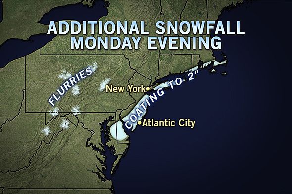
The heaviest snow will focus over part of South Jersey into Monday evening and could briefly swing into central and eastern Long Island for a time Monday night, following rain. These areas have the best chance at picking up a quick couple of inches. The timing of the snow along the mid-Atlantic coast should coincide with when road surfaces are cooling Monday evening.
As the storm heads out to sea later Monday night, precipitation will shut down from west to east from the western suburbs of the I-95 cities to the coast. However, pockets of flurries and intermittent snow will remain behind over the Appalachians and the Ohio Valley.
From Washington, D.C., to Baltimore, Wilmington, Philadelphia, Trenton and New York City, precipitation falling for part of the day on Monday fought the March sun effect. Even when concealed by clouds, enough energy gets through to warm road surfaces, causing some or all of the snow to melt.
It has to snow very hard in urban areas to overwhelm the sun effect and accumulate on paved and concrete surfaces during the middle of the day. The greatest amount of snow will be on grassy and elevated surfaces from Washington, D.C. to Trenton, N.J. The snow had more success accumulating northwest and southeast of this major urban highway.
http://local.msn.com/WeatherArticle.aspx?cp-documentid=256943846
No comments:
Post a Comment