It's not too often that you hear about a volcano forcing the closure of an airport, but it is for Bali and their 120 active volcanos. Ngurah Rai International Airport was closed Monday and Tuesday for reasons including the ash that spouts from the top of the volcano. This ash can be detrimental for airplanes as it clouds their line of vision and gets into the engine.
Not only has the airports been closed but families have been evacuated from a six-mile radius of the volcano. The last major eruption was in 1963 and killed about 1,100 people. The highest alerts have been put out a warning about the volcanoes activity.
Brace yourselves! This week meteorologists have predicted a severe weather pattern moving in the direction of the Northern Hemisphere. Scientists say that this is likely to "bring a brutal Arctic blast across the Midwest and eastern U.S., put Western Europe into the deep freeze, and maintain an area of extreme cold in eastern Asia". And if this isnt enough, many believe that "The cold air blowing across the comparatively mild waters of the Great Lakes could yield prolific lake effect snows". Whatever the situation, Dec. 10th will be the true test of winter.
According to The National Oceanic and Atmospheric Administration (NOAA) the eastern U.S. will not be facing the wrath of a truly wintery winter. It will not be chilly for long.
Currently it is colder than average in the eastern United States, with bits of the midwest, and warmer than the average in most of the West. This is from a block of air over the North Pacific which is allowing the push of cold air southward, making the unseasonably chilly temperatures after our uncomfortably warm autumn. The Southwest seems to be the only consistent area with its averages, and it seems like it will stay that way.
The Northeast cold is going to continue past Thanksgiving, due to the Greenland block. And it is believed that this will be the only cold we get this year, through most of the country.
La Nina is a huge reason for these warmer temperatures, with NOAA forecasting strangely warmer weather than what most people are used to for the time. This most likely means a green Christmas is in the forecast. Though, NOAA also predicts that La Nina will be weaker than other years, meaning weather changes will not be too strong or too sudden.
But nothing is set in stone for this winter yet. The true forecast will only be known once we are deeper into the season. Original Article found here: https://www.popsci.com/weather-winter-2017-noaa
The coldest air of the season so far will descend on Germany this week, setting the stage for low-elevation snowfall.
Winter coats will be needed throughout the entire country this week as high temperatures tumble several degrees below normal by Thursday and Friday.
Normal high temperatures across Germany in late November range from 5-6 C (41-42 F).
Tuesday will be the mildest of the next several days, with high temperatures near normal across the country.
By Friday afternoon, temperatures will only be able to climb to 1-3 C (34-38 F) across much of Germany, with some locations struggling to reach 0 C (32 F).
“Limited sunshine and occasional gusty winds this week will also make it feel even colder,” said AccuWeather Meteorologist Faith Eherts.
Lowering temperatures each day this week will also allow for snow to fall for the first time in many locations.
Locations from Frankfurt to Stuttgart, Nuremberg and Munich will be at the highest risk for accumulating snowfall.
A few snowflakes are also possible from Cologne and Hamburg to Berlin, with the best chance for accumulation during the overnight hours as temperatures fall close to or just below freezing.
“Cities, for the most part, will only see a coating of snowfall at any given time, but could have significant travel disruption due to slippery roadways,” added Eherts.
Dramatic temperature swings will set the stage for an array of disruptive weather to sweep across the midwestern United States through Sunday.
The North Central states will remain at the heart of the battle between the last vestiges of summer warmth and crisp, fall air. High temperatures can vary up to 15 degrees Fahrenheit from one day to the next into early next week.
This seesaw pattern will lead to areas of snow and a wintry mix to the north and rain and locally strong thunderstorms to the south as systems roll through into Sunday.
Wintry weather may cause slick roads across northern tier
Following snow that swept through the region at midweek, the northern Plains and Upper Midwest will face a couple more waves of wintry weather that can lead to travel disruptions into Sunday.
The first wave of snow will continue to sweep across Montana, North Dakota, north-central Minnesota, northern Wisconsin and the Upper Peninsula of Michigan through Saturday.
“While most areas will see a general 1-3 inches of accumulation, any areas where heavier snow bands set up could see as much as 4 or 5 inches,” AccuWeather Meteorologist Ryan Adamson said.
The snow will quickly stick to roadways given the cold that has settled over the region. Bridges and overpasses along interstates 29, 35 and 94 could be icy.
“As warmer air lifts northward, the snow could end as some drizzle or even freezing drizzle in some areas,” Adamson said.
Authorities and residents in Colorado are trying to figure out what caused a mysterious, loud booming sound Monday night, the latest in a series of strange booms reported across the country.
According to the Tech Times, residents in the Colorado towns of Lakewood, Brighton, Lochbuie and Elizabeth reported what sounded like an "explosion" or a "sonic boom" around 9 p.m. The boom was so powerful that it shook windows and left people bewildered, and some just a little frightened.
"It was just like boom and the trailer shook, and I thought, 'what the heck was that?’” resident Ray Armijo told ABC7. "It kind of scared me a bit.”
Lochbuie Police Chief Tracey McCoy told ABC7 there were no reports of property damage or injuries but residents remained a little shook up.
"Some stuff in my room visibly moved," Aleja Moronez said. "Some posters fell off the wall."
Authorities do not know the source of the sound. The Federal Aviation Administration and nearby Buckley Air Force Base said there were no operations at the time of the incident.
One theory is that the sound was a meteorite or a bolide, which is a large meteorite that explodes in the atmosphere. Others speculated on the Lochbuie Police Department's Facebook page that the sound might have come from a deep earthquake or even, some joked, an alien invasion.
Booming sounds have also been reported in other parts of the United States, including New Jersey, Alabama, Idaho and Detroit.
The Colorado boom comes less than a week after the so-called "Bama Boom" shook parts of Alabama.
The persistent warmth that has dominated the southwestern U.S. recently will lead to additional daily record-warm temperatures early this week and will keep several cities on track for setting a record for warmest November.
Much of the West has experienced above-average temperatures recently, with numerous daily record highs set during the week of Thanksgiving.
These above-average temperatures are courtesy of a strong upper-level ridge of high pressure, or northward bulge of the jet stream, that has been in place over the West for much of November.
An upper-level ridge of high pressure will allow temperatures to be well above average in parts of the West and Plains early this week.
This setup will keep warm and dry conditions in place for portions of the region early this week.
Daily record highs have been set across the region over the past week, and this record-setting streak will likely continue over the next couple days.
Sunday, numerous record highs for the date were set across the Southwest and the Rockies:
Tucson, Arizona: 92 degrees (old record was 86 degrees in 1998) – also the latest 90-degree day on record
Phoenix, Arizona: 89 degrees (old record was 88 degrees in 1950)
Denver: 74 degrees (old record was 72 degrees in 1998)
Flagstaff, Arizona: 73 degrees (old record was 70 degrees in 1949)
Cheyenne, Wyoming: 69 degrees (old record was 67 degrees in 1998)
Saturday, several daily record highs occurred in portions of the Southwest and California:
Tuscon, Arizona: 88 degrees (old record was 86 degrees in 1894)
San Jose, California: 80 degrees (old record was 76 degrees in 1959)
Las Vegas, Nevada: 76 degrees (ties record of 76 degrees in 1970)
Eureka, California: 74 degrees (old record was 70 degrees in 1977)
Flagstaff, Arizona: 73 degrees (old record was 70 degrees in 1949)
The upper-level ridge of high pressure will begin to slide eastward Monday ahead of a low-pressure system. Southwesterly flow ahead of this system will result in high temperatures 15 to 30 degrees above average from the Southwest into the central Rockies and into much of the Plains. Downslope flow will also help temperatures to rise in some areas, including the High Plains of Colorado.
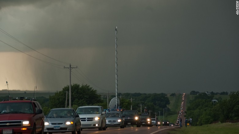
(CNN)The movie "Twister," the prevalence of smartphone technology, the glorification of extreme tornado videos on the Web and TV: The reasons for the popularity explosion of storm chasing are many, and they can lead to dangerous consequences.
Storm chasing is generally defined as pursuing severe thunderstorms with the intent to witness, photograph or scientifically measure the intensity of the storms, with chasers frequently focusing on the development of tornadoes.
It was once the hobby of a select few meteorologists and tornado researchers, fueled by their curiosity and desire to witness the weather that was often the focus of their studies. Storm chasing also provided real-world applications for their forecasting.
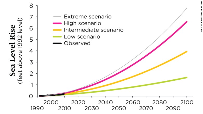
(CNN)For the past several years, scientists have been trying to get people to wake up to the dangers that lie ahead in rising seas due to climate change. A comprehensive list now names hundreds of US cities, large and small, that may not make it through the next 20, 50 or 80 years due to sea level rise.
Featuring places like New York, Boston, San Francisco and Miami, the list paints a grim picture of what our nation could look like if sea level predictions are accurate.
The left panel shows current high tide and the extended reach of extreme tides, which defines a chronic inundation, or limited-use zone. The right panel shows how sea level rise later in the century has expanded the reach of not just extreme tides but also more typical tides such that some land is permanently inundated and a greater portion of the community is chronically flooded.
If you live along the coast, your city could be one of them -- meaning you could be part of the last generation to call it home.
"This research hones in on exactly how sea level rise is hitting us first. The number of people experiencing chronic floods will grow much more quickly than sea level itself," Benjamin Strauss, vice president for Sea Level and Climate Impacts at Climate Central said in reaction to this study.
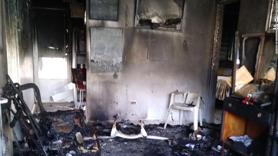
Cayey, Puerto Rico (CNN)People on this part of the island knew Quintín Vidal Rolón for two things: his white cowboy hat, which he seemed to wear every day of his 89-year life; and his beat-up Ford pickup truck, which he'd been driving for at least 50 years.
It was in that 1962 truck, and wearing that hat, that Vidal spent his days zipping around the mountainous back roadsof Cayey, Puerto Rico. He sold hardware from the wooden bed of the pickup. And he used those tools, and a lifetime of sweat, to build houses -- always in concrete.
Like him, the material was nothing if not consistent. It was strong enough to stand up to a storm, he told clients and family members. Don't trust anything less durable.
After Hurricane Maria slammed into this US territory on September 20, peeling roofs from wooden homes and amputating branches from trees, the community turned again to Vidal. No one can say exactly how many people survived the storm in the hard-caststructures he helped construct for them, often at little or no cost. But it's likely hundreds, his family said.
The first day of summer brought
some of the worst heat the Southwest U.S. has seen in years, forcing
flights to be canceled, straining the power grid and making life
miserable for workers toiling in temperatures that reached 120 degrees
or higher in some desert cities.
Arizona, Nevada and
California saw dramatic temperatures Tuesday as researchers say deadly
heat waves like this one were going to grow more frequent.
Meteorologists
in Phoenix said Tuesday evening the temperature topped out at 119
degrees — one that has been matched or surpassed only four other times.
The
forecast called for a high of 120 degrees in Phoenix, which it hasn't
seen in more than two decades. Death Valley, Calif., reached 125 and
Palm Springs hit 121, still a degree lower than the same day last year.
The operator of California's power grid called on people to conserve electricity during peak hours.
Workers
at a construction site in a Phoenix suburb huddled under an excavator
to find a sliver of a shade during a break. At another building site,
men in hard hats and yellow vests labored and sweated in the heat,
downing water to stay hydrated. Project superintendent Tommy Russell
says his company has held weekly safety meetings to prepare for the
heat, and he will send his workers home if it hits 120.
Las
Vegas also baked. Visitors tried to stay inside air-conditioned
casinos, and some tourists lugged packs of bottled water around the
Strip. Others went to a bar where the temperature is set at 23 degrees
and glasses, walls and seats are sculpted from ice.
Tonya and Lavonda Williams traveled to
Sin City from Orlando, Fla., to see the Backstreet Boys in concert.
Walking on the Strip in 112 degrees was too much to handle, even for
people accustomed to heat.
"This
is like the oven door is open," Lavonda Williams said as the sisters
walked from a pedestrian bridge into the Palazzo casino-resort.
"It's too hot to even drink alcohol," Tonya Williams added.
Landscaper
Juan Guadalupe scaled a spindly palm tree more than 50 feet tall in
Phoenix, using a chain saw to hack the branches. He didn't mind being
tethered to a tall tree because he occasionally catches a cool breeze.
"Down here, it's hot," Guadalupe said.
With
cooling and hydration stations in full swing across the region,
hundreds flocked to Grace Lutheran Church in Phoenix for water and
refuge.
"We have homeless people come from a long way to
sit here," longtime volunteer Moses Elder said. "There are other spots
where you can go get cold water and sit down and cool off, but there are
few places you can lay down and get something to eat."
Phoenix has hit 120 only three times in recorded history. The record high was 122 degrees on June 26, 1990.
In
Palm Springs, Jim Brooks only had to walk 50 yards from his car to a
burger restaurant but felt like he nearly melted in the process.
"I
almost didn't think lunch would be worth it," the 30-year-old told the
Desert Sun newspaper. "I was sort of hitting myself for leaving home. I
have air conditioning there."
The weather comes as new
research found that nearly one in three people now experience 20 days a
year when the heat reaches deadly levels. The study of nearly 2,000
deadly heat waves worldwide since 1980 was published Monday in the
journal Nature Climate Change.
In the Southwest U.S., the heat has caused several problems this week.
In
addition to grounding more than 40 flights of smaller planes, airlines
have been taking other measures on larger jets to reduce their weight.
American Airlines spokesman Ross Feinstein said the carrier began
limiting sales on some flights to prevent the planes from exceeding
maximum weight for safe takeoff in the hot conditions.
The main burn center in Phoenix warned people to be careful around car interiors and pavement and with their pets.
About
50 people went a PetSmart store in a Phoenix suburb Tuesday to receive
free elastic booties to put on their pets' paws so they don't burn on
concrete and pavement.
Shelby Barnes, 48, picked up three
sets of the booties for her dogs. She said she yells at people who walk
their dogs without them in the afternoon heat.
"If you can't put your foot on the sidewalk, neither can they," she said.
http://www.chicagotribune.com/news/nationworld/ct-southwest-heat-wave-20170620-story.html
The
most visible evidence of how dry the 1930s became was the dust storm.
Tons of topsoil were blown off barren fields and carried in storm clouds
for hundreds of miles. Technically, the driest region of the Plains –
southeastern Colorado, southwest Kansas and the panhandles of Oklahoma
and Texas – became known as the Dust Bowl, and many dust storms started
there. But the entire region, and eventually the entire country, was
affected.The Dust Bowl got its name after Black Sunday, April
14, 1935. More and more dust storms had been blowing up in the years
leading up to that day. In 1932, 14 dust storms were recorded on the
Plains. In 1933, there were 38 storms. By 1934, it was estimated that
100 million acres of farmland had lost all or most of the topsoil to the
winds. By April 1935, there had been weeks of dust storms, but the
cloud that appeared on the horizon that Sunday was the worst. Winds were
clocked at 60 mph. Then it hit.
"The impact is like a shovelful
of fine sand flung against the face," Avis D. Carlson wrote in a New
Republic article. "People caught in their own yards grope for the
doorstep. Cars come to a standstill, for no light in the world can
penetrate that swirling murk... We live with the dust, eat it, sleep
with it, watch it strip us of possessions and the hope of possessions.
It is becoming Real."
The day after Black Sunday, an Associated
Press reporter used the term "Dust Bowl" for the first time. "Three
little words achingly familiar on the Western farmer's tongue, rule life
in the dust bowl of the continent – if it rains." The term stuck and
was used by radio reporters and writers, in private letters and public
speeches.
In the central and northern plains, dust was everywhere.
The
impact of the Dust Bowl was felt all over the U.S. During the same
April as Black Sunday, 1935, one of FDR's advisors, Hugh Hammond
Bennett, was in Washington D.C. on his way to testify before Congress
about the need for soil conservation legislation.
A dust storm arrived in Washington all the way from the Great Plains.
As a dusty gloom spread over the nation's capital and blotted out the
sun, Bennett explained, "This, gentlemen, is what I have been talking
about." Congress passed the Soil Conservation Act that same year.
https://livinghistoryfarm.org/farminginthe30s/water_02.html
Last December, many Chicagoans woke up to see wispy layers of fog rolling off of Lake Michigan. This is a fairly common weather event that happens when a mass of very cold air blows over warmer water, often called arctic sea smoke or sea fog. On this particular day, the air above the lake was 3 degrees and the water was 35 degrees.
When the cold air blows over the warm water, the water near the surface evaporates into the colder air above and increases the humidity in the air. When the air reaches its dewpoint, the vapor condenses into fog.
This phenomenon really only happens when there are strong winds driving the colder wind out over the lake. This weird effect can happen even if Lake Michigan is covered in ice .
All throughout the nation, cities have been reporting early snowfall and extreme cold. Many people are wondering, will it snow for Thanksgiving? According to meteorologist Tom Kines, "It's not out of the question that if the precipitation came in early enough Thursday, you might have to worry about ice or maybe snow at the start [of the day]". While this is not a very forward answer, it does give us a hint that there will be some ice on the roads. It is better to be cautious then sorry. The temperature is said to dip into the low thirties, giving us the strong guess for snow, but Kines says this ice will not last too long.
For some parts of the US like the great plains and the midwest, the winter has already come and settled in. Starting as early as the end of october, regions all across the United States have felt the icy breath of winter. Examples of this are the rockies, mississippi valley and Northwest. Joining these areas in mid november are "much of the midwest and east".
According to the Accumulated Winter Season Severity Index, twelve cities have already been hit by what is classified as extreme weather. In Duluth, the city has already had a quarter of their average snowfall come through the region. In the Northwest, Seattle saw their earlier snowfall in over 120 years. These reports file in from all over the country and tell us that Winter will not be over as soon as we hope.
Shelf clouds, also called arc clouds, are typically seen at the leading edge of a squall line of thunderstorms. Although they might look similar, shelf clouds are nothing like tornadoes; what you see in a shelf cloud is the boundary between the downdraft and the updraft of a thunderstorm. Rain-cooled air descends in the downdraft then spreads when it reaches the earth's surface, then warmer, moist air is lifted at the gust front of the rain-cooled air. When the warmer air condenses, a shelf cloud forms.
Shelf clouds, after they have passed, can cause strong wind gusts and heavy rain or hail. These wind gusts can be so strong that they are able to knock over trees and power lines.
La Niña conditions have officially developed and may continue through early 2018, potentially influencing the weather conditions we see in the United States this winter, according to an update issued by NOAA on Thursday.
La Niña is the periodic cooling of the equatorial eastern and central Pacific Ocean. When sea-surface temperatures are cooler than average by at least 0.5 degrees Celsius, along with consistent atmospheric indications, a La Niña is considered to be in place.
NOAA said oceanic and atmospheric signals in October and early November are consistent with a weak La Niña. You can see the strip of cooler-than-average sea-surface temperatures near the equator as of early November in the graphic below.
The black box highlights the cooler-than-average sea-surface temperatures near the equator indicating La Niña conditions on Nov. 9, 2017.
There is a 65- to 75-percent chance of weak La Niña conditions continuing through the winter months ahead based on the latest forecast guidance, NOAA said. This would mark the second consecutive winter with weak La Niña conditions as a potential weather influence.
We may already be observing some influence from La Niña on weather conditions in the U.S. this fall with early low-elevation snow and below-average temperatures in the Northwest during October and early November. This is consistent with what is typically observed in that region of the country during La Niña events.
First off, no single La Niña produces the exact same outcome.
La Niña, El Niño or the lack of either, known as the neutral phase, is only one large-scale forcing on the atmosphere. It is not the sole factor in determining whether a season is wet, dry, cold or warm. Other atmospheric influences are in play, including atmospheric blocking.
Nevertheless, there are some general themes to expect in a La Niña winter, according to NOAA:
Southern U.S.: Above-average temperatures and below-average precipitation.
Northern U.S.: Below-average temperatures (particularly northern Plains and Northwest) and above-average precipitation.
Winter outlooks issued in October by The Weather Company, an IBM Business, and NOAA both had a strong La Niña flavor in terms of the temperature and precipitation expectations.
Below-average temperatures are most likely in the Northwest and Upper Midwest, while the South is forecast to be warmer than average.
Winter Temperature Outlook
The red contour in the South corresponds to higher probabilities of above-average temperatures. The darker blue areas in the Northwest and Upper Midwest have the highest odds of below-average temperatures. The light blue and orange contours show where temperatures may be slightly below or slightly above average, respectively. (The Weather Company, an IBM Business)
Portions of the Ohio Valley, Great Lakes and northern Rockies have the highest odds of above-average precipitation this winter. Depending on temperatures at any given time this winter, we could see increased odds of snow in those regions.
Meanwhile, the South could be in for a dry winter, which is typical during La Niña. If this pans out as forecast, there is the possibility of growing drought conditions in parts of the Southeast, and it may also give a boost to wildfire danger in this region next spring.
Winter Precipitation Outlook
Dark green shaded areas in the Great Lakes, Ohio Valley and the northern Rockies have the greatest odds for above-average precipitation this winter. Locations highlighted in dark brown across the South have the highest probability of drier-than-average conditions. Areas not shaded have an equal chance of seeing precipitation below, above or near average. (NOAA)
During last winter's weak La Niña, the West and Upper Midwest had one of the wettest winters on record, while a large swath of the East, South and Midwest had one of the warmest winters since record-keeping began.
Neither El Niño nor La Niña is expected through winter. The so-called neutral conditions still offer clues on what winter could bring.
This neutral phase means there is no push in the atmosphere in either direction from the equatorial Pacific water. This lack of forcing can make it more difficult to predict the weather pattern in the months ahead, and there are many other elements to consider.
NOAA indicates that the polar jet stream may be shifted farther south and have more of a tendency to allow colder-than-average air into portions of the Midwest and Northeast during a neutral winter.
Meanwhile, much of the southern tier of the U.S. may end up with a warmer-than-average winter overall.
In addition, the subtropical jet stream may shift the track of storms to bring an overall wet winter to much of the South. The Pacific storm track may also result in low-pressure systems moving more into the Northwest versus California compared to a typical El Niño winter.
However, it is important to note that this is just an overall trend of the season from December through February as a whole. Individual cold fronts and low-pressure systems will deviate from this at times.
Sea surface temperature differences compared to average in degrees Celsius. Area in red box highlights where sea surface temperatures are monitored for possible El Niño or La Niña conditions.
(NOAA)
When sea-surface temperatures are warmer than average in the eastern and central equatorial Pacific by at least 0.5 degrees Celsius for at least three months along with consistent atmospheric indications, an El Niño is considered to be in place. When sea-surface temperatures are colder than average by at least 0.5 degrees over that same period, a La Niña is in effect.
The latest NOAA update indicates a 55 percent chance of neutral conditions continuing through this winter.
Impacts on Hurricane Season, Fall From a Neutral Phase
Potential winter weather pattern when El Niño and La Niña are absent.
(NOAA)
Neutral conditions have been factored into this fall's temperature forecast, with most of the contiguous U.S. likely to see near-to-above-average temperatures. The exception is the Pacific Northwest where near-to-slightly-below-average conditions are currently anticipated through fall.
A lack of El Niño conditions has already played a role in the Atlantic hurricane season forecast.
El Niño can result in widespread and hostile upper-level winds in the Atlantic Basin, which inhibits the formation of tropical cyclones. Without the unfavorable winds that El Niño was expected to bring, there is a higher chance for a more active Atlantic hurricane season than previously forecasted.
El Niño and La Niña are different phases of the El Niño-Southern Oscillation (ENSO) pattern. ENSO refers to the fluctuations in temperature between the ocean and atmosphere in the eastern and central equatorial Pacific that can shift back and forth irregularly every two to seven years.
Each phase of ENSO can trigger some notable changes in temperature, precipitation and winds in the equatorial Pacific. These changes can then disrupt large-scale air movement in the tropics and consequently weather across the globe.
ENSO conditions are just one piece of a large puzzle in determining the weather in a given season or month.

/https%3A%2F%2Fblueprint-api-production.s3.amazonaws.com%2Fuploads%2Fcard%2Fimage%2F663550%2F0e59de11-59c7-4629-8e32-83751336a372.jpg)