Showing posts with label wangyiyongqian. Show all posts

Monday, November 27, 2017

Germany: Biting cold, snow showers on tap this week

The coldest air of the season so far will descend on Germany this week, setting the stage for low-elevation snowfall.
Winter coats will be needed throughout the entire country this week as high temperatures tumble several degrees below normal by Thursday and Friday.
Normal high temperatures across Germany in late November range from 5-6 C (41-42 F).
Tuesday will be the mildest of the next several days, with high temperatures near normal across the country.
By Friday afternoon, temperatures will only be able to climb to 1-3 C (34-38 F) across much of Germany, with some locations struggling to reach 0 C (32 F).
“Limited sunshine and occasional gusty winds this week will also make it feel even colder,” said AccuWeather Meteorologist Faith Eherts.
Lowering temperatures each day this week will also allow for snow to fall for the first time in many locations.
Locations from Frankfurt to Stuttgart, Nuremberg and Munich will be at the highest risk for accumulating snowfall.
A few snowflakes are also possible from Cologne and Hamburg to Berlin, with the best chance for accumulation during the overnight hours as temperatures fall close to or just below freezing.
“Cities, for the most part, will only see a coating of snowfall at any given time, but could have significant travel disruption due to slippery roadways,” added Eherts.
https://www.accuweather.com/en/weather-news/germany-biting-cold-and-snow-showers-on-tap-this-week/70003382
Germany 11/27

Storms to threaten midwestern US with snow, locally severe weather through this weekend

Dramatic temperature swings will set the stage for an array of disruptive weather to sweep across the midwestern United States through Sunday.
The North Central states will remain at the heart of the battle between the last vestiges of summer warmth and crisp, fall air. High temperatures can vary up to 15 degrees Fahrenheit from one day to the next into early next week.
This seesaw pattern will lead to areas of snow and a wintry mix to the north and rain and locally strong thunderstorms to the south as systems roll through into Sunday.
Wintry weather may cause slick roads across northern tier
Following snow that swept through the region at midweek, the northern Plains and Upper Midwest will face a couple more waves of wintry weather that can lead to travel disruptions into Sunday. MW Saturday regional 11.4 AM
The first wave of snow will continue to sweep across Montana, North Dakota, north-central Minnesota, northern Wisconsin and the Upper Peninsula of Michigan through Saturday.
“While most areas will see a general 1-3 inches of accumulation, any areas where heavier snow bands set up could see as much as 4 or 5 inches,” AccuWeather Meteorologist Ryan Adamson said.
The snow will quickly stick to roadways given the cold that has settled over the region. Bridges and overpasses along interstates 29, 35 and 94 could be icy.
“As warmer air lifts northward, the snow could end as some drizzle or even freezing drizzle in some areas,” Adamson said.
https://www.accuweather.com/en/weather-news/storms-to-threaten-midwestern-us-with-snow-locally-severe-weather-through-this-weekend/70003170

Sunday, November 26, 2017

Mystery in Colorado: Loud Booming Sound Frightens Residents, Baffles Authorities

Authorities and residents in Colorado are trying to figure out what caused a mysterious, loud booming sound Monday night, the latest in a series of strange booms reported across the country. 
According to the Tech Times, residents in the Colorado towns of Lakewood, Brighton, Lochbuie and Elizabeth reported what sounded like an "explosion" or a "sonic boom" around 9 p.m. The boom was so powerful that it shook windows and left people bewildered, and some just a little frightened.
"It was just like boom and the trailer shook, and I thought, 'what the heck was that?’” resident Ray Armijo told ABC7. "It kind of scared me a bit.”
Lochbuie Police Chief Tracey McCoy told ABC7 there were no reports of property damage or injuries but residents remained a little shook up.
"Some stuff in my room visibly moved," Aleja Moronez said. "Some posters fell off the wall."
Authorities do not know the source of the sound. The Federal Aviation Administration and nearby Buckley Air Force Base said there were no operations at the time of the incident.
One theory is that the sound was a meteorite or a bolide, which is a large meteorite that explodes in the atmosphere. Others speculated on the Lochbuie Police Department's Facebook page that the sound might have come from a deep earthquake or even, some joked, an alien invasion. 
Booming sounds have also been reported in other parts of the United States, including New Jersey, Alabama, Idaho and Detroit.
The Colorado boom comes less than a week after the so-called "Bama Boom" shook parts of Alabama.

https://www.wunderground.com/news/2017-11-24-colorado-booming-sounds 

Early-Week Record Warmth Will Keep Several Southwestern Cities on Track to Experience Warmest November on Record

Linda Lam 
Published: November 26, 2017

The persistent warmth that has dominated the southwestern U.S. recently will lead to additional daily record-warm temperatures early this week and will keep several cities on track for setting a record for warmest November.
Much of the West has experienced above-average temperatures recently, with numerous daily record highs set during the week of Thanksgiving.
These above-average temperatures are courtesy of a strong upper-level ridge of high pressure, or northward bulge of the jet stream, that has been in place over the West for much of November.
An upper-level ridge of high pressure will allow temperatures to be well above average in parts of the West and Plains early this week.
This setup will keep warm and dry conditions in place for portions of the region early this week.
Daily record highs have been set across the region over the past week, and this record-setting streak will likely continue over the next couple days.
Sunday, numerous record highs for the date were set across the Southwest and the Rockies:
  • Tucson, Arizona: 92 degrees (old record was 86 degrees in 1998) – also the latest 90-degree day on record
  • Phoenix, Arizona: 89 degrees (old record was 88 degrees in 1950)
  • Denver: 74 degrees (old record was 72 degrees in 1998)
  • Flagstaff, Arizona: 73 degrees (old record was 70 degrees in 1949)
  • Cheyenne, Wyoming: 69 degrees (old record was 67 degrees in 1998)
Saturday, several daily record highs occurred in portions of the Southwest and California:
  • Tuscon, Arizona: 88 degrees (old record was 86 degrees in 1894)
  • San Jose, California: 80 degrees (old record was 76 degrees in 1959)
  • Las Vegas, Nevada: 76 degrees (ties record of 76 degrees in 1970)
  • Eureka, California: 74 degrees (old record was 70 degrees in 1977)
  • Flagstaff, Arizona: 73 degrees (old record was 70 degrees in 1949)
The upper-level ridge of high pressure will begin to slide eastward Monday ahead of a low-pressure system. Southwesterly flow ahead of this system will result in high temperatures 15 to 30 degrees above average from the Southwest into the central Rockies and into much of the Plains. Downslope flow will also help temperatures to rise in some areas, including the High Plains of Colorado.
https://www.wunderground.com/news/2017-11-25-record-warm-november-temperatures-southwest-plains

There's a storm chaser traffic jam in Tornado Alley

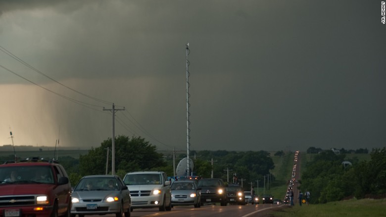
(CNN)The movie "Twister," the prevalence of smartphone technology, the glorification of extreme tornado videos on the Web and TV: The reasons for the popularity explosion of storm chasing are many, and they can lead to dangerous consequences.Storm chaser convergence can cause backups for miles near dangerous storm systems.
Storm chasing is generally defined as pursuing severe thunderstorms with the intent to witness, photograph or scientifically measure the intensity of the storms, with chasers frequently focusing on the development of tornadoes.
It was once the hobby of a select few meteorologists and tornado researchers, fueled by their curiosity and desire to witness the weather that was often the focus of their studies. Storm chasing also provided real-world applications for their forecasting.
http://www.cnn.com/2017/05/18/us/storm-chaser-convergence/index.html

Higher seas to flood dozens of US cities, study says; is yours one of them?

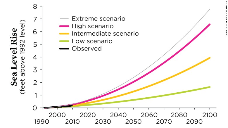
(CNN)For the past several years, scientists have been trying to get people to wake up to the dangers that lie ahead in rising seas due to climate change. A comprehensive list now names hundreds of US cities, large and small, that may not make it through the next 20, 50 or 80 years due to sea level rise.
Featuring places like New York, Boston, San Francisco and Miami, the list paints a grim picture of what our nation could look like if sea level predictions are accurate.
If you live along the coast, your city could be one of them -- meaning you could be part of the last generation to call it home.
    "This research hones in on exactly how sea level rise is hitting us first. The number of people experiencing chronic floods will grow much more quickly than sea level itself," Benjamin Strauss, vice president for Sea Level and Climate Impacts at Climate Central said in reaction to this study.
    http://www.cnn.com/2017/07/12/us/weather-cities-inundated-climate-change/index.html

    We surveyed 112 Puerto Rican funeral homes to check the accuracy of the hurricane death toll. This is what we found.

    Cayey, Puerto Rico (CNN)People on this part of the island knew Quintín Vidal Rolón for two things: his white cowboy hat, which he seemed to wear every day of his 89-year life; and his beat-up Ford pickup truck, which he'd been driving for at least 50 years.
    It was in that 1962 truck, and wearing that hat, that Vidal spent his days zipping around the mountainous back roads of Cayey, Puerto Rico. He sold hardware from the wooden bed of the pickup. And he used those tools, and a lifetime of sweat, to build houses -- always in concrete.
    Like him, the material was nothing if not consistent. It was strong enough to stand up to a storm, he told clients and family members. Don't trust anything less durable.
    After Hurricane Maria slammed into this US territory on September 20, peeling roofs from wooden homes and amputating branches from trees, the community turned again to Vidal. No one can say exactly how many people survived the storm in the hard-cast structures he helped construct for them, often at little or no cost. But it's likely hundreds, his family said.

    http://www.cnn.com/2017/11/20/health/hurricane-maria-uncounted-deaths-invs/index.htmlOne family member described Quintín Vidal Rolón's home on October 20 as a "hellscape."


    Monday, November 13, 2017

    Strong Winds, Snow, Cold Air, Severe Storms Expected in Midwest and East; Chilly Pattern May Linger Thanksgiving Week

    A potent storm system will bring strong winds, heavy rain, snow and possibly severe storms to the Midwest and East late this week while ushering in cold temperatures that may stay in place through Thanksgiving.
    Strong low pressure moves through the Great Lakes this weekend with cold air diving southward behind the storm.


    This storm system could cause delays for those getting an early start on Thanksgiving travel this weekend. Details on any travel impacts for Thanksgiving week itself are too early to pinpoint this far out in time(MORE: Winter Storm Central)
    Here's an overview of what to expect from the late-week storm followed by an overview of Thanksgiving week.

    Late-Week Storm: Cold Plunge Follows Midwest, Eastern Storm

    Sometimes, the transition to a new weather pattern is accompanied by a significant storm.
    In this case, a sharp jet stream plunge will induce a low-pressure system to strengthen quickly over the Great Lakes and eastern Canada Friday into Saturday, producing wind-whipped snow in the colder air and heavy rain in the warmer air ahead of the cold front. There is also a risk of severe thunderstorms on the warm side of this weather system.
    The Great Lakes snowbelts may see heavy snow, and snow or a wintry mix is also possible in parts of the interior Northeast from this system Friday into the weekend.
    Friday
    • Snow, or rain changing to snow, along with gusty winds, may affect parts of the upper Midwest and the western and northern Great Lakes regions.
    • Showers and thunderstorms should spread through the southern Great Lakes, Ohio Valley, Mississippi Valley and South. Severe storms with damaging winds will be possible in the Ohio and Mississippi valleys.
    • A wintry mix may develop in upstate New York and interior New England by Friday night.

    96L Southwest of the Azores May Become Subtropical Storm Sean


    Above:  MODIS satellite image of 96L taken on Monday morning, November 13, 2017. Image credit: NASA
    A non-tropical low-pressure system with the potential to develop into a subtropical storm was located in the east-central Atlantic about 600 miles southwest of the Azores Islands on Monday morning. This system was designated Invest 96L by NHC over the weekend. The low is moving slowly northeastward towards the Azores, which is the only land area that needs to be concerned with this storm.
    Conditions were marginally favorable for development on Monday, with moderate wind shear of 15 knots and ocean temperatures of 24°C (75°F). These temperatures are probably too cool to allow transition of 96L to a fully tropical storm, but may be warm enough to allow 96L to become a subtropical storm deserving of a name. Satellite loops on Monday morning showed that 96L was already beginning to take on some characteristics of a subtropical storm, with a large area of heavy thunderstorms located in a curved band more than 100 miles from the cloud-free center of circulation. In their 7 am EST  Tropical Weather Outlook, NHC gave 96L 2-day and 5-day odds of development of 30% and 50%, respectively. The next name on the Atlantic list of storms is Sean.

    https://s.w-x.co/wu/96L-nov13.jpeg

    Icy mix may trigger slick Monday morning commute in central Appalachians

    Just enough snow and ice could occur across a portion of the northeastern United States to trigger travel headaches during the Monday morning commute.
    Roads and sidewalks have become sufficiently cold in the wake of an Arctic push for even a light wintry mix to stick and create a slick glaze on untreated surfaces, especially at night.
    Travelers may need to allot extra time to reach their destinations and should use caution over bridges and overpasses.


    The system that spread a chilly rain and areas of snow and sleet across the lower Great Lakes region on Sunday will push eastward to start the new week.
    A mix of snow and sleet arrived in the northern mid-Atlantic and interior Northeast on Sunday night, and is expected to last into Monday, AccuWeather Lead Long-Range Meteorologist Paul Pastelok said.

    NE regional 11/13
    “While a heavy accumulation is not anticipated, just enough snow and sleet or freezing rain may occur to glaze some roads and sidewalks,” AccuWeather Senior Meteorologist Alex Sosnowski said.
    A large portion of Pennsylvania as well as western and central New York state, and the high terrain of West Virginia and Maryland could face a slippery Monday morning commute.

    https://www.accuweather.com/en/weather-news/icy-mix-may-trigger-slick-monday-morning-commute-in-central-appalachians/70003252

    Thanksgiving outlook: Brutal cold, snow to blast Midwest as a storm may eye the East


    While warmth builds in the Southwest, re-surging cold air may trigger frequent snow in the Great Lakes and help spin up a storm along the East Coast around Thanksgiving Day.
    Following a storm and shot of cold air that sweeps across the northern part of the nation into this weekend, there is the potential for very cold air to take root over the Midwest during the long Thanksgiving weekend.
    "If early indications are correct, some locations may be buried under feet of lake-effect snow, while gusty winds sweep cold air from the northern Plains to the Gulf Coast, Appalachians and eventually the Atlantic Seaboard," according to AccuWeather Senior Meteorologist Brett Anderson.

    It is during that press of arctic air, when another storm may come about with a swath of steady rain, ice and snow in the Northeast.
    At the jet stream level, a piece of the polar vortex may break loose and settle near the Great Lakes. The jet stream is a high speed river of air at the level where jets cruise at.
    The polar vortex is a storm around the same level of the atmosphere as the jet stream. Usually this storm hangs out near the Arctic Circle and keeps frigid air contained. However, when this storm weakens or shifts position, cold air may be discharged to mid-latitudes anywhere around the globe.
    "The cold outbreak with lake-effect snow from the Midwest to the central Appalachians may last a couple of days or perhaps right through the Thanksgiving weekend," according to AccuWeather Meteorologist Evan Duffey.
    https://www.accuweather.com/en/weather-news/thanksgiving-outlook-brutal-cold-snow-to-blast-midwest-as-a-storm-may-eye-the-east/70003263


    Major storm may precede rush of polar air in northeastern US prior to Thanksgiving

    A disruptive storm packing rain, wind and snow may evolve in the eastern half of the United States as Thanksgiving travel begins to ramp up late this week and into next weekend.
    Motorists along major thoroughfares in the East could face slow travel and difficult driving conditions. Airline passengers may have to adjust flight times due to delays and cancellations.
    Ripple-effect airline travel delays may result elsewhere across the country.
    The storm will be spawned as polar air drops southward across the Midwest and East late this week and into the coming weekend.
    “We will have to wait and see the exact storm track, but at least some travel delays can be expected across the Northeast from heavy rain, snow and some rather strong winds,” AccuWeather Long-Range Meteorologist Evan Duffey said.
    https://www.accuweather.com/en/weather-news/major-storm-may-precede-rush-of-polar-air-in-northeastern-us-prior-to-thanksgiving/70003255

    Wednesday, August 30, 2017

    Hurricane Andrew hit 25 years ago and joined ranks of historic U.S hurricanes

    By any standard, Hurricane Andrew was historic. It was the third-strongest hurricane to make landfall in the United States since reliable records had been kept, with top wind speeds of 165 miles per hour.Andrew shocked a generation that had never experienced such a hurricane, engendering a deep respect for the power of these huge rotating storms.

    Certainly there’s more to significance than just how strong they are,” he said. “Hurricane Katrina in 2005 was certainly not among the most intense in terms of wind speed. It was a Category 3. But that one became infamous because the water-retention mechanisms that were in place didn’t hold up. Galveston too, was deadliest but nowhere near strongest. Hurricane Andrew is way up there. Andrew was one of the very few that ever hit the United States as a Category 5 hurricane.”


    The storm destroyed 28,000 homes. It forced insurance companies to pay more than $15.5 billion in claims. It accounted for 15 direct deaths, a toll many considered light, considering the vast area of destruction. Another 25 were counted as indirect deaths, and the Miami Herald reported another 43 deaths that could be linked to the storm, a figure now used by the National Hurricane Center.


    http://www.sun-sentinel.com/news/florida/fl-reg-hurricane-andrew-anniversary-20170823-story.html