Thursday, February 28, 2013

Mid Atlantic get hit with snow again!?


A wintry system that will make a cross-country tour beginning this weekend has the potential to develop into a major storm along the East Coast next week.
The storm is cruising northern Pacific waters to close out this week and will push into the Pacific Northwest this weekend with a modest dose of rain and mountain snow.
In fact, most of the life of this storm as it traverses the Northwest (March 2-3), then the northern Rockies and central Plains into early next week (March 3-4) will not be blockbusting news


Read more: http://www.foxnews.com/weather/2013/02/28/mid-atlantic-major-snowstorm-potential-next-week/#ixzz2MFJ2wcmm

Record Warm for Cali, then turns back to cold


Californians can get ready for a warm weekend. The area most likely to see numerous record highs challenged on Friday and Saturday is Southern California, west of the mountains.
The reason that Southern California will see the most amount of records broken or challenged is that there will also be an offshore flow in place.


Read more: http://www.foxnews.com/weather/2013/02/28/when-will-record-warmth-hit-california/#ixzz2MFHgYSjQ

My Compilation of pictures of the Chicago Blizzard. Feb 26.2013


A custodian begins the task of scraping a sidewalk along Adams Street east of Clinton Street in Chicago.Two women hunker down into their coats seeking protection from the winter storm as they walk through downtown Naperville.

NEXT  ▶
A woman sweeps the snow off of a car in the 3400 block of North Monticello Avenue in Chicago on Monday.

Midwest Snow

It's snow season in America, and although the East Coast has been hogging all the weather-attention this year, the Midwest put Blizzard Nemo to shame on Thursday. It's not so much that the storm system moving through the central United States dumped more snow on the ground. This week's storm simply dumped snow on more ground, affecting 20 states over the course of an hour. CNN put the scope of the storm in startling terms, "About 60 million people -- 20% of the U.S. population -- were under winter weather warnings, watches and advisories in the 750,000 square miles affected." And yes, there was thundersnow. It even snowed in the middle of the Arizona desert.

Link Snow--- http://news.yahoo.com/midwest-one-big-snowy-wreck-now-035836176.html

Volatile Weather

Link---- http://www.newsnet5.com/dpp/weather/weather_news/active-weather-pattern-likely-to-continue-into-march-for-northern-ohio

CLEVELAND - February has certainly been an active month for weather. We've had several battles with bitter cold Arctic air. In between, we catch a break and warm up into the 40s. So far, for the month of February, temperatures have averaged 3.5 degrees BELOW normal. Snowfall is currently measuring 19 inches (+ 7.6") with still another week left in the month.


snowy roads, generic, low visibility

Children stranded at school because of snow


DENVER (AP) — A snowstorm moving across the Midwest forced about 60 students to spend the night at their Colorado school when a state highway was closed due to dangerous conditions that left some drivers stranded in their cars, as winter weather continued to cause problems for a wide swath of the country.
Tens of thousands remained without power in Michigan, while adverse conditions continued to disrupt flights at Chicago's O'Hare Airport. In eastern Wisconsin, hundreds of vehicles were stranded or ended up in crashes as a winter storm made travel dangerous. And in Kansas, the latest snowstorm to hit the state was being blamed for six deaths.

Link: http://news.yahoo.com/colo-kids-stranded-school-overnight-snow-162605660.html
In this photo provided by Sharon Webb, principal of Miami-Yoder School, students sleep on the floor at the school on Wednesday, Feb. 25, 2013, in Yoder, Colo. About 60 students were forced to spend the night at the school after snow drifts closed roads in the area. The students went home later Wednesday after the roads were cleared. (AP Photo/Sharon Webb)

Black Hole


LOS ANGELES — There's a new spin on supermassive black holes: They're incredibly fast, astronomers say.
It's long been suspected that gigantic black holes lurking in the heart of galaxies rotate faster and grow larger as they feast on gas, dust, stars and matter. But there hasn't been a reliable measurement of the spin rate of a black hole until now.
While black holes are difficult to detect, the region around them gives off telltale X-rays. Using NASA's newly launched NuStar telescope and the European Space Agency's workhorse XMM-Newton, an international team observed high-energy X-rays released by a supermassive black hole in the middle of a nearby galaxy.
Link-----  http://www.weather.com/news/science/space/supermassive-black-hole-spins-fast-20130228

Top 10 Cities with the Coldest starts toward the month of March

Link : http://www.weather.com/news/weather-winter/march-sadness-cold-start-east-20130222


What is the first thing to pop into your head when we mention, "March?"  Spring?  Spring Break?  Spring training?
Yes, spring officially arrives on March 20, but most residents of the Northeast, Midwest, and Rockies know March can be a frustrating month, featuring lagging cold, snow, and wind.  March, by its very nature is changeable for most in the Lower 48 States.  

Drought eases up in the south

Link----http://www.weather.com/news/drought/drought-improves-southeast-plains-20130228


Heavy rainfall in the Southeast and a pair of heavy snow events in the Plains have made dents in the long-term drought in each region.  
According to the latest Drought Monitor report released Thursday from the National Drought Mitigation Center, "extreme" drought, the second worst category of drought in this weekly analysis, has been erased from the Southeast region (from Alabama and Florida to Virginia) for the first time since August 2010

.

Big Snow Day in the Chi

Link:::  http://www.accuweather.com/en/weather-news/chicago-snow-february/7011533


The 4.8 inches of snow for the day at O'Hare broke the previous record snowfall for Feb. 26 in Chicago, a record set in 1935.
From the start of the snow event late Tuesday morning through daybreak Wednesday, a total of 5.4 inches were measured at Chicago O'Hare International Airport. This snowfall total makes the event the largest snowfall of the season for Chicago thus far, making up 28% of the 2012-2013 winter snowfall total.

High Temps in California

Link to article--- http://www.accuweather.com/en/weather-news/california-record-warmth/7092269


Californians can get ready for a warm weekend. The area most likely to see numerous record highs challenged on Friday and Saturday is Southern California, west of the mountains.
The reason that Southern California will see the most amount of records broken or challenged is that there will also be an offshore flow in place.

Wednesday, February 27, 2013

Tuesday's Record-Breaking Snow in Chicago


The 4.8 inches of snow for the day at O'Hare broke the previous record snowfall for Feb. 26 in Chicago, a record set in 1935. The National Weather Service Office in Chicago recorded 2.2 inches of snow, and Midway Airport picked up 3.6 inches.
With 14.1 inches so far at O'Hare and 8.7 inches of snow so far at Midway this month, the storm also made February a top-20 snowiest February in Chicago.
Tuesday's snow total at Rockford, Ill., was 4.1 inches, so only 0.2 of an inch more of snow needs to fall to make February 2013 a top-five snowiest February for the city.


Read more: http://www.foxnews.com/weather/2013/02/27/tuesday-record-breaking-snow-in-chicago/#ixzz2MA1uTwuW

Cyclone loses power after crossing Western Australia


A major storm has missed Australia's major iron ore port and crossed a sparsely populated stretch of the west coast.
The Bureau of Meteorology said in a statement Thursday that Cyclone Rusty was weakening as it tracked inland from the coast of Western Australia state but remained destructive with gusts up to 125 kph (78 mph).
Port Hedland was relatively unscathed by the storm that was gusting up to 230 kilometers (140 miles) per hour late Wednesday as it crossed the coast from the Indian Ocean to the south of the town.
Port Hedland residents were returning to their homes from storm shelters on Thursday after the bureau declared the danger there had passed. The iron ore export facilities were shut down on Wednesday for fear of damage.


Read more: http://www.foxnews.com/world/2013/02/27/cyclone-loses-power-after-crossing-western-australia-cost-missing-major-iron/#ixzz2MA1TAXeK


Storm that buried Plains slams Great Lakes region


CHICAGO (Reuters) - A powerful winter storm that buried the U.S. Plains moved on Tuesday into the southern Great Lakes region, where it snarled the evening commute in Chicago and Milwaukee, created near-whiteout conditions and forced hundreds of flight cancellations.
Wind gusts of up to 35 miles per hour (56 km per hour) hurled a potent blend of wet snow and sleet on north-central Illinois, southern Wisconsin and northern Indiana and Ohio, according to the National Weather Service. As the afternoon rush hour began in Chicago, blowing snow reduced visibility and created treacherous driving conditions, doubling average travel times in and out of the city on major expressways, according to Traffic.com.


Article: http://www.chicagotribune.com/news/sns-rt-us-usa-weather-snowstormbre91n0eh-20130225,0,1299304.story

Biggest snow of the season not quite finished


The storm that socked the Chicago area with the season's biggest snowfall has tapered off, but it's not completely finished with us.
Snow will continue falling periodically today, dropping another inch or two in the city and up to three inches in the northern suburbs, according to the National Weather Service.
That means the morning rush hour could be a bit messy, though it shouldn't be nearly as bad as Tuesday evening's commute was for motorists like Bob Reed of Geneva. Speaking from a cellphone as he crawled west on Interstate 90, Reed blamed sloppy drivers more than sloppy roads.

Article: http://www.chicagotribune.com/news/local/breaking/chi-heavy-snow-expected-to-hit-the-evening-rush-20130226,0,4350095.story

Storm watch issued: Snow, freezing rain, sleet

Fran%20Volz%20touches%20up%20a%207-foot%20snow%20angel%20in%20his%20backyard%20in%20Elgin%2C%20Illinois.%20After%20almost%20every%20snow%20fall%2C%20Volz%20sculpts%20something%20new%20for%20his%20community%20to%20enjoy.%20%28Stacey%20Wescott%2C%20Chicago%20Tribune%29

For the second time in less than a week, the Chicago area is in line for a snowstorm that promises a mixture of freezing rain, sleet and snow with enough accumulation to bring out the snow shovels.
Early predictions from the National Weather Service pegged the potential snowfall at about 3-6 inches, about what the storm left the end of last week. But the weather service says it's still unclear which areas will be hit with what: If the temperature is above freezing, there will be less snow, and if it's below, there will be more.

Website: http://articles.chicagotribune.com/2013-02-25/news/chi-chicago-weather-forecast-report_1_sleet-snow-winter-storm

Tuesday, February 26, 2013

Northeast begins dig-out after deadly snowstorm, thousands without power

More than 220,000 homes and businesses remain remained without power Sunday as the U.S. Northeast and Canada dug out from a blizzard that dumped up to 3 feet (a meter) of snow on the most densely populated part of the region. The death toll was at 15.
Some motorists had to be rescued after spending hours stuck in wet, heavy snow. Utilities in some hard-hit New England states predicted that the storm could leave some customers in the dark at least until Tuesday. About 650,000 lost power in eight states at the height of the storm.
"We've never seen anything like this," said county official Steven Bellone of New York's Long Island, where hundreds of drivers had been caught on highways by Friday's fast-moving storm. Local police said Sunday that all known abandoned cars were searched and no one needing medical help was found.
At least 11 deaths in the U.S. and four in Canada were blamed on the snowstorm, including an 11-year-old boy in Boston who was overcome by carbon monoxide as he sat in a running car to keep warm while his father shoveled Saturday morning.
Roads were impassable, and cars were entombed by snow drifts. Some people couldn't open the doors of their homes.
"It's like lifting cement," said Michael Levesque, who was shoveling snow in Massachusetts.
Blowing with hurricane-force winds, the storm hit hard along the heavily populated corridor between New York City and Maine.
Most outages were in hard-hit Massachusetts, where some 180,000 customers remained without power on Sunday, officials said some of the outages might linger until Tuesday.
New York City's three major airports -- LaGuardia, Kennedy and Newark, New Jersey -- were up and running by late Saturday morning after shutting down the evening before. Boston's Logan Airport resumed operations late Saturday night.

http://www.foxnews.com/weather/2013/02/10/snowstorm-slams-boston-new-york-city-as-residents-are-urged-to-stay-off-roads/?intcmp=trending

Thousands without power as second major snowstorm wallops Missouri, Kansas

The second major snowstorm in a week battered the nation's midsection Tuesday, dropping a half-foot or more of snow across Missouri and Kansas and cutting power to thousands. Gusting winds blew drifts more than 2 feet high and created treacherous driving conditions for those who dared the morning commute.
About 40,000 people in northwest Missouri and northeast Kansas awoke to no power as heavy, wet snow weighed on power lines. Kansas City, Mo., was in a state of emergency as blinding snowfall -- made worst by sustained gusts estimated at 30 mph or higher -- made car and truck traffic too dangerous. About 8 inches of new snow had fallen on parts of the Kansas City metro area as the sun rose Tuesday.
Flights in and out of Kansas City International Airport were canceled, schools, government offices and businesses across the region were closed. City buses were getting stuck.
Numerous accidents were reported in the area, and Mayor Sly James declared the emergency in an unwanted encore to a major snowstorm that dumped nearly a foot of snow on his city just five days earlier. He urged residents to stay home, given that the new storm was expected to dump nearly a foot of new snow on the city.

http://www.foxnews.com/weather/2013/02/26/thousands-without-power-as-second-major-snow-storm-wallops-missouri-kansas/?test=latestnews?intcmp=trending

NASA Probes Show 'Alarming' Water Loss in Middle East


Parts of the Middle East are losing groundwater reserves at “an alarming rate,” according to a new analysis of NASA satellite data.
From the beginning of 2003 to the end of 2009, portions of Iran, Iraq, Turkey and Syria that lie within the Tigris and Euphrates river basins shed 117 million acre-feet of water. That’s roughly equivalent to the volume of the Dead Sea.
About one-fifth of that water disappeared during a drought that began in 2007, which decreased snowpack that feeds the rivers and dried out soils. Another 20 percent of the lost water came from surface lakes and reservoirs.
But the bulk of the water loss — about 60 percent — came from aggressive groundwater pumping, said the new study, which was published in the journal Water Resources Research.
That includes 1,000 new groundwater wells the Iraqi government dug between 2007 and 2009, to compensate for water lost when it increased flows from its major reservoir, Qadisiyah, to raise drought-lowered river levels along the Euphrates.

Midwest Storm: Expect More Snow and Beware Freezing Rain


A wide-reaching winter storm is causing or expected to cause massive travel headaches from Colorado to West Virginia to New Hampshire over the next four days. The storm – with snow, freezing rain, and some thunderstorms – will hit metropolitan areas such as Albany, Boston, Chicago, Denver, Kansas City, Little Rock, St Louis, and Springfield, Massachusetts.

The main story here for snow is how many states will meet winter storm warning criteria (usually over 6in in this geographical area) over the next 48 hours. Snow amounts of over 6in will be expected to fall over six states including Illinois, Iowa, and Minnesota. More than 4in can be expected in the south-eastern part of South Dakota, Michigan's upper peninsula, and pretty much the whole of Wisconsin.

Most of the snow from this part of the storm is expected to fall over the next 24 hours. The exceptions are the northern part of Wisconsin, including Green Bay, and most of Michigan, including Marquette, where snow will likely linger into Saturday.
The snow is expected to mix with sleet and freezing rain along the southern part of the storm system. St Louis and Springfield will see snow amounts of around 3-6in. The snow should mix with and change to sleet and freezing rain. Farther to the south and east freezing rain is likely to be the big story.
The freezing rain will be the most dangerous part of the storm. It is caused by snow that melts on its way to the surface and then freezes on contact with the surface. It differs from sleet, which is snow that melts and refreezes into little ice pellets on its way to the surface. Any ice that forms from freezing rain can create treacherous travel conditions and knock out power lines.

Study: Climate Change May Dry Up Important U.S. Reservoirs Like Lake Powell And Lake Mead


As climate change makes the regions of the West, Southwest, and Great Plains warmer and drier, water demand will continue to increase, and the combined effect will place an ever greater burden on the country’s fresh water supplies — possibly completely draining important reservoirs in those areas, under some scenarios. That’s according to a new study authored by researchers with Colorado State University, Princeton and the U.S. Forest Service, andflagged yesterday by Summit County Citizens Voice.
This is consistent with other studies on the risk of future water shortages: The Department of the Interior is anticipating that by 2060 the gap between river supply and water demand in the states of the Colorado River Basin will be 3.2 million acre feet due to climate change. Research published in Environmental Science and Technology found that by 2050 one third of U.S. counties could face “high” or “extreme” risk of water shortage. And the International Energy Agency determined that if current policies remain in place, fresh water use by the energy industry alone could more than double — from 66 to 135 billion cubic meters annually by 2035.
Climate change, substantially driven by global warming and humanity’s carbon emissions, is anticipated to lead to more weather extremes in various areas — longer periods of low precipitation and water shortage in many areas, interspersed with greater deluges. And, of course, higher average temperatures to bake the same regions as they dry out. The Forest Service study used a number of different scenarios in its models, assuming different levels of future population growth, economic growth, and temperature increases:
[F]uture climate change will increase water use for agricultural irrigation and landscape maintenance in response to rising plant water requirements, and at thermoelectric plants to accommodate rising electricity demands for space cooling. Including these effects, per-capita withdrawals are projected to drop only moderately for the next few decades and then level off as the effects of climate change become greater, and total withdrawals are projected to rise nearly continuously into the future. Projected withdrawals differ across the global emissions scenarios examined, especially in the latter decades of the century.
Although precipitation is projected to increase in much of the United States with future climate change, in most locations that additional precipitation will merely accommodate rising evapotranspiration demand in response to temperature increases. Where the effect of rising evapotranspiration exceeds the effect of increasing precipitation, and where precipitation actually declines, as is likely in parts of the Southwest, water yields are projected to decline. For the United States as a whole, the declines are substantial, exceeding 30% of current levels by 2080 for some scenarios examined.


link to article

Ice Melt Means Uneven Sea Level Rise Around the World


LONDON – Scientists say the sea level rise caused by climate change during the rest of this century will not affect all parts of the world equally, because of the ways sea, land and ice interact.
They say parts of the Pacific are likely to see the highest rise. This region is where many low-lying island countries most vulnerable to sea level rise, like the Seychelles, are already struggling. Their peoples will need evacuation if the scientists’ high-end predictions are correct. Northern Europe, on the other hand, will experience a below-average increase.
Researchers have found that ice melt from glaciers and from the Greenland and Antarctic ice sheets is likely to be critically important to regional sea-level change in the equatorial Pacific ocean.
Credit: Christine Zenino via Climate News Network.
The team, from Italy’s University of Urbino and the University of Bristol, U.K., report their findings in a paper, The gravitationally consistent sea-level fingerprint of future terrestrial ice loss, published in Geophysical Research Letters online.
Scientists have known for some time that sea level rise around the globe will not be uniform. The team investigated how ice loss will continue to add to rising sea levels until the year 2100. The researchers, from the European Union’s Ice2sea project, show in detail the global pattern of sea level rise that would result from two scenarios of ice-loss from glaciers and ice sheets.
Improved projections of the contribution of ice to sea level rise produced by Ice2sea will feed into the fifth assessment report of the Intergovernmental Panel on Climate Change. In 2007, the IPCC’s fourth report highlighted ice-sheets as the most significant remaining uncertainty in projections of sea-level rise.
The researchers found that ice melt from glaciers and from the Greenland and Antarctic ice sheets is likely to be critically important to regional sea-level change in the equatorial Pacific ocean.

Legacy of the Ice Age

There the rise will be greater than the global average increase, affecting in particular western Australia, Oceania and the small atolls and islands in the region, including Hawaii. Another area which should expect an above-average increase is the east coast of South Africa and Madagascar.
The study focussed on three effects that lead to the unequal distribution of sea level rise. First, land is both subsiding into and emerging from the sea because of a massive ice loss at the end of the last Ice Age 10,000 years ago, when billions of tonnes of ice covering parts of North America and Europe melted.

Chicago Winter Storm

Chicago Pelted by Snow and Sleet

A winter weather advisory is in effect until tonight as the Chicago area is getting hit with sleet, freezing rain and snow that is making travel hazardous and grounding hundreds of flights.
The National Weather Service expects the heaviest snow to fall this afternoon. Winds gusting at 35 to 40 mph will reduce visibility and glaze roads, the weather service warned in the advisory.
"Snowfall rates in excess of an inch per hour could occur at times," it said. "This will likely be a heavy wet snow sometimes referred to as heart attack snow."

Extreme Weather Linked to Giant Waves

Extreme Weather Linked to Giant Waves in Atmosphere

Tanya Lewis, LiveScience Staff Writer Published: Feb 26, 2013, 0:25 PM EST From our partners
NASA
Sratocumulus clouds photographed by the Expedition 34 crew members aboard the International Space Station above the northwestern Pacific Ocean about 460 miles east of northern Honshu, Japan on Jan. 4, 2013.
Extreme weather events have been on the rise in the last few decades, and man-made climate change may be causing them by interfering with global air-flow patterns, according to new research.
The Northern Hemisphere has taken a beating from extreme weather in recent years — the 2003 European heat wave, the 2010 Pakistan flood and the 2011 heat wave in the United States, for example. These events, in a general sense, are the result of the global movement of air.
Giant waves of air in the atmosphere normally even out the climate, by bringing warm air north from the tropics and cold air south from the Arctic. But a new study suggests these colossal waves have gotten stuck in place during extreme weather events.
http://www.weather.com/news/science/environment/extreme-weather-atmosphere-waves-20130226

Historic Blizzard


Blizzard warnings were set to expire at midnight across the Texas Panhandle, CNN meteorologist Sean Morris said.
The powerful storm will move northeast through Oklahoma on Monday night, prompting blizzard warnings there.
Blizzard conditions are expected to move into south central Kansas early Tuesday, bringing another round of heavy snow to Wichita, which just experienced record snowfall last week.
As the storm moves into eastern Kansas, winds will die down and whiteout conditions are less likely. However, heavy snow is still forecast with snowfall totals over a foot in some areas of southeast Kansas.
The storm is leaving behind a huge mess in its wake.
Almost all roads in the Texas Panhandle were impassable Monday, and the state Department of Transportation pulled virtually all of its snowplows off roads because of whiteout conditions, Texas DOT spokesman Paul Braun said Monday morning.
Full Story: http://www.cnn.com/2013/02/25/us/weather-winter-storm/index.html

Monday, February 25, 2013

Blizzard blasts southern Plains


None

A ferocious blizzard blasted the southern Plains with heavy snow and high winds Monday, burying much of the Texas and Oklahoma panhandles under more than a foot of snow, wreaking travel havoc on the roads and in the air.
Overnight Monday and through the day Tuesday, the storm will slowly slog to the north and east, bringing a swath of snow across Kansas, Missouri, Illinois, Wisconsin and Michigan, the National Weather Service reported.
"This storm will have a huge impact, with additional heavy snows likely over portions of eastern Kansas and northern Missouri which received very heavy snowfall amounts last week," weather service meteorologist Robert Oravec wrote in an online bulletin.
The storm is being blamed for two deaths on Monday. In northwest Kansas, a 21-year-old man's SUV hit an icy patch on Interstate 70 and overturned. And in the northwest town of Woodward, Okla., heavy snow caused a roof to collapse, killing one inside the home.


Full Story: http://www.usatoday.com/story/weather/2013/02/24/2nd-blizzard-plains/1945161/

Worker Rest Breaks Double by 2050 as Climate Warms: NOAA

Worker Rest Breaks Seen Doubling by 2050 as Global Climate Warms


People working in jobs without air conditioning will need to take breaks twice as often by 2050 to avoid heat stress amid a warming climate, according to a study by the National Oceanic and Atmospheric Administration.
Losses in labor capacity, or the ability to work safely in warm conditions, will double by mid-century assuming global temperatures rise by 1 degree Celsius (1.8 degrees Fahrenheit), according to the study published yesterday in Nature Climate Change. Temperatures have risen 0.7 degrees since before the Industrial Revolution in the 1800s.“The planet will start experiencing heat stress that’s unlike anything experienced today,” Ronald Stouffer, a physical scientist at NOAA’s Geophysical Fluid Dynamics Laboratory in Princeton, New Jersey, and co-author of the report, said on a conference call with reporters. “The world is entering a very different environment and the impact on labor will be significant.”
The study, which covers work outdoors at night and in the shade and indoor work without air conditioning, uses guidelines set by industry and the military for a safe workplace in hot conditions. Today, people working when temperatures peak must rest about 10 percent of their working time. That will double to 20 percent by 2050, according to the study.

Full Story: http://www.businessweek.com/news/2013-02-24/worker-rest-breaks-double-by-2050-as-climate-warms-noaa

County Responds to Severe Weather


County Responds to Severe Weather


Officials encourage use of Leon County’s Emergency Information Portal and Emergency Alerts Leon County Emergency Management continues to closely monitor the current weather situation related to severe weather including thunderstorms and flooding.
As a result, Leon County Emergency Management and Leon County Public Works have made sandbag operations available for residents to use.

http://www.wctv.tv/home/headlines/Sand-and-Bags-Being-Offered-in-Tallahassee-193084641.html


High threat for fires in Texas, yet just below a blizzard


A threat for fire will be in effect for parts of Texas Monday, just south of a blizzard that will impact the Northern Texas Panhandle.
AccuWeather.com Senior Meteorologist Frank Strait said that a combination of dry air and strong winds will contribute to the threat for small fires to ignite and spread rapidly.


Caution should be used to prevent the spread of fire, by making sure all camp fires are put out and all cigarettes are adequately put out.

Read more: http://www.foxnews.com/weather/2013/02/24/high-fire-danger-for-southern-texas/#ixzz2LxdUClCI

A taste of the rainbow


A storm, bringing a blizzard to part of the Plains, will swing through the Northeast with a period of rain on the coast and everything from heavy snow to a wintry mix and rain inland and farther north during the middle days of the week.
The nature of the storm will be very complex in the Northeast, and the form of precipitation may change many times over its history in some locations.
Regardless of the form of precipitation, the storm will cause travel disruptions.


Read more: http://www.foxnews.com/weather/2013/02/25/snow-mix-rain-may-disrupt-travel-in-east/#ixzz2Lxcmk5FR

Philippines Economy Suffering Due to Super Typhoon

http://www.guardian.co.uk/world/2013/feb/17/filipino-super-typhoon-climate-change


Filipino super-typhoon an ominous warning of climate change impact

Philippines is having to adapt and adjust to rapidly deteriorating climatic trends at a great cost to its economy
Destroyed banana trees
Thousands of banana trees toppled by Bopha in New Bataan, Philippines. Photograph: Ted Aljibe/AFP/Getty Images
When super-typhoon Bopha struck without warning before dawn, flattening the walls of their home, Maria Amparo Jenobiagon, her two daughters and her grandchildren ran for their lives.
The 
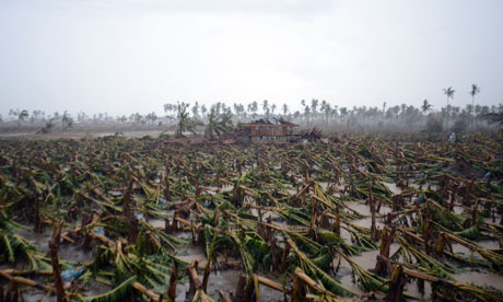
storm on 4 December was the worst ever to hit the southern Philippines: torrential rain turned New Bataan's river into a raging flood. Roads were washed away and the bridge turned into an enormous dam. Tens of thousands of coconut trees crashed down in an instant as unbelievably powerful winds struck. The banana crop was destroyed in a flash – and with it the livelihoods of hundreds of farmers.
The only safe place the family could think of was the concrete grandstand at the village sports stadium. Two months later, Jenobiagon, 36, and her three-year-old granddaughter, Mary Aieshe, are still there, living in one of the improvised tents spanning its steep concrete tiers along with hundreds of other people.
"We were terrified. All we could hear was loud crashing. We didn't know what to do. So we came here," Jenobiagon said. "Everyone ran to the health centre but houses were being swept away and the water was neck deep. Everywhere we went was full of mud and water. We went to a school but it was flooded, so we came to the stadium."
Lorenzo Balbin, the mayor of New Bataan, said the fury of the storm was far beyond the experience of anyone living in Mindanao. It would take 10 years to replace the coconut crop, he said. Some villages in Compostela Valley may be too unsafe to live in.
Bopha, known locally as Pablo, broke records as well as hearts. At its height, it produced wind speeds of 160mph, gusting to 195mph. It was the world's deadliest typhoon in 2012, killing 1,067 people, with 800 left missing. More than 6.2 million people were affected; the cost of the damage may top $1bn. As a category 5 storm (the highest), Bopha wassignificantly more powerful than hurricane Katrina (category 3), which hit the US in 2005, and last year's heavily publicised hurricane Sandy(category 2).
With an estimated 216,000 houses destroyed or damaged, tens of thousands of people remain displaced, presenting a challenge for the government and aid agencies.
The lack of international media coverage of Bopha may in part be explained – though not excused – by western-centric news values, and in part by the high incidence of storms in the Pacific region.
The Philippines experiences an average of 20 typhoons a year (including three super-typhoons) plus numerous incidents of flooding, drought, earthquakes and tremors and occasional volcanic eruptions, making it one of the most naturally disaster-prone countries in the world.
But more disturbing than Bopha's size was the fact that it appeared to reflect rapidly deteriorating climatic trends.
The five most devastating typhoons recorded in the Philippines have occurred since 1990, affecting 23 million people. Four of the costliest typhoons anywhere occurred in same period, according to an Oxfam report. What is more, Bopha hit an area where typhoons are all but unknown.
The inter-governmental panel on climate change says mean temperatures in the Philippines are rising by 0.14C per decade. Since the 1980s, there has been an increase in annual mean rainfall. Yet two of the severest droughts ever recorded occurred in 1991-92 and 1997-98.
Scientists are also registering steadily rising sea levels around the Philippines, and a falling water table. All this appears to increase the likelihood and incidence of extreme weather events while adversely affecting food production and yields through land erosion and degradation, analysts say.
Mary Ann Lucille Sering, head of the Philippine government's climate change commission, is in no doubt her country faces a deepening crisis that it can ill afford, financially and in human terms. Typhoon-related costs in 2009, the year the commission was created, amounted to 2.9% of GDP, she said, and have been rising each year since then.
"Extreme weather is becoming more frequent, you could even call it the new normal," Sering said. "Last year one typhoon [Bopha] hurt us very much. If this continues we are looking at a big drain on resources." Human activity-related "slow onset impacts" included over-fishing, over-dependence on certain crops, over-extraction of ground water, and an expanding population (the Philippines has about 95 million people and a median age of 23).
"Altogether this could eventually lead to disaster," Sering said. Unlike countries such as Britain, where changing weather has a marginal impact on most people's lives, climate change in the Philippines was "like a war". Opinion surveys showed that Filipinos rated global warming as a bigger threat than rising food and fuel prices, she said.
Even given this level of awareness, Bopha presented an enormous test for emergency services. Oxfam workers in Davao City, working with the UN, local NGO partners, and the government's National Disaster Risk Reduction and Management Council (NDRRMC), quickly moved to the area to offer assistance. Oxfam has committed $2m in Bopha relief funds on top of its annual $4m Philippines budget. But the UN-co-ordinated Bopha Action Plan, which set an emergency funding target of $76m, has received only $27m so far.
The overall post-Bopha response has comprised three phases: immediate help, including the provision of shelter and clean water, sanitation and hygiene facilities; rebuilding and relocation; and mitigation and prevention measures.
"The first thing was to provide water bladders to the evacuation centre in New Bataan. We concentrated on providing emergency toilets and water systems," said Kevin Lee, response manager for the Humanitarian Response Consortium, a group of five local NGOs. "We had a 15-strong team from Oxfam and the HRC, digging holes and putting in plastic pipes. Next we started looking at emergency food and shelter.
"The devastation was worse than anything I have ever seen. Up to 90% of the coconut trees were just flattened. That's the local economy on the ground. And that's really difficult to fix quickly," Lee said. But his team's swift action had positive results, he added. There have been no water-borne diseases in New Bataan and no outbreak of cholera.
The consortium has now moved on to longer-term projects such as building a waste management plant, setting up markets at relocation sites, and working on disaster risk reduction programmes, so that when the next typhoon hits, local people may be better prepared.
The Lumbia resettlement project outside Cagayan de Oro, in northern Mindanao, provides an example of what can be achieved. Here, victims of tropical storm Washi, which swept through the area in 2011, killing 1,200 people and causing nearly $50m in damage, have been offered newly-built homes on land owned by the local university.
The Lumbia project's slogan is "build a community, not just homes", and it has gone down well with displaced villagers. "It's better here than before. It's more elevated, we don't have to worry about floods," said Alexie Colibano, a Lumbia resident. "Before we were living on an island in the river. Now we feel more secure."
About 15,000 Bopha victims remain in evacuation centres, including in the New Bataan stadium grandstand. In total, about 200,000 are still living with friends or relatives.
In Manila, meanwhile, Benito Ramos, the outgoing executive director of the NDRRMC, is busy planning for the next super-typhoon. "We are preparing for a national summit this month on how to prepare, including early warning, building codes, land use regulations, geo-hazard mapping, relocation and livelihoods," he said.
But the bigger issue is climate change, which posed an "existential threat" to the Philippines, Ramos said. "We are mainstreaming climate change in all government departments and policies. If we don't adapt and adjust, we all agree we are heading for disaster."