New York and Philadelphia lie outside the danger zone, but Chicago and Boston could experience a heavy dump of snow
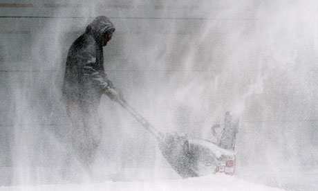
A man clears snow from a house in Wichita, Kansas. Photograph: Jaime Greene/AP
A wide-reaching winter storm is causing or expected to cause massive travel headaches from Colorado to West Virginia to New Hampshire over the next four days. The storm – with snow, freezing rain, and some thunderstorms – will hit metropolitan areas such as Albany, Boston, Chicago, Denver, Kansas City, Little Rock, St Louis, and Springfield, Massachusetts.
First part of the storm (through Friday)
A primary low pressure system is dropping healthy snow amounts over the middle of the country. Highest snowfall will be contained in south-eastern Nebraska, north-eastern Kansas, and north-western Missouri, which will receive up to and perhaps just greater than a foot.
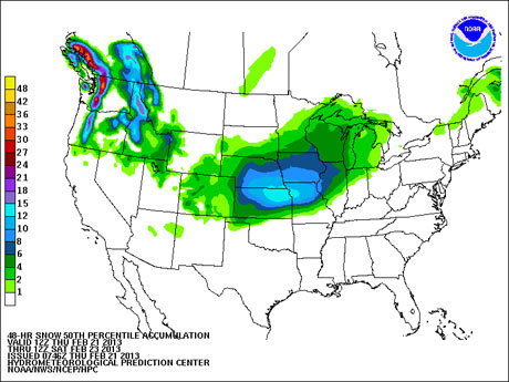
The main story here for snow is how many states will meet winter storm warning criteria (usually over 6in in this geographical area) over the next 48 hours. Snow amounts of over 6in will be expected to fall over six states including Illinois, Iowa, and Minnesota. More than 4in can be expected in the south-eastern part of South Dakota, Michigan's upper peninsula, and pretty much the whole of Wisconsin.
Most of the snow from this part of the storm is expected to fall over the next 24 hours. The exceptions are the northern part of Wisconsin, including Green Bay, and most of Michigan, including Marquette, where snow will likely linger into Saturday.
The snow is expected to mix with sleet and freezing rain along the southern part of the storm system. St Louis and Springfield will see snow amounts of around 3-6in. The snow should mix with and change to sleet and freezing rain. Farther to the south and east freezing rain is likely to be the big story.
The freezing rain will be the most dangerous part of the storm. It is caused by snow that melts on its way to the surface and then freezes on contact with the surface. It differs from sleet, which is snow that melts and refreezes into little ice pellets on its way to the surface. Any ice that forms from freezing rain can create treacherous travel conditions and knock out power lines.
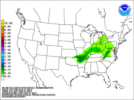
Freezing rain amounts of up to and perhaps over half an inch is expected to fall over the next 24 hours in northern Arkansas – where ice storm warnings are in effect – and southern Missouri. Thunderstorms are likely along this southern front as warm Gulf air mixes with cold air from the north. It's possible that hail, which is not a wintry form of precipitation, actually mixes in with the freezing rain.
Lower amounts of freezing rain will spread eastward from the heaviest batch. Accumulations of over a tenth of an inch will expand eastward to central Indiana, southwestern Ohio, and eastern West Virginia over the next two days. Though amounts will be small, any freezing accumulation on roads should not be taken lightly.
Second part of the storm (Saturday into Sunday)
The main low pressure affecting the middle of the country is going to die over the next 48 hours, because it will run into a wall of high pressure in central Canada. In response, a secondary lower pressure system will form along the eastern seaboard on Saturday.
Most of the major cities in the north-east will get mostly rain or nothing at all. New York and Philadelphia are not in line for any real accumulation. Washington DC could be the exception, with some sleet on Friday thanks to the weakening primary in the midwest.
The real action will be in central New York state and interior New England, where amounts of over a foot and perhaps up 2ft could fall. I feel fairly safe in saying that cities such as Albany, Manchester, New Hampshire, and Springfield, Massachusetts are going to get socked on Saturday into Sunday. The Hydrometeorological Prediction Center is printing out around a foot by Sunday morning, with possibly more snow through the day.
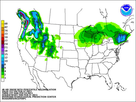
The question zone is likely to be from the Hartford-to-Boston axis. With no true high pressure source to the north, warm air from the south will try and invade Hartford. Any snow could mix with sleet, and perhaps become rain. Boston could see a strong eastern wind that could bring in rain and keep amounts down.
The jackpot zone is going to be in an area that manages to stay cold enough for snow, and close enough to the main precipitation shield. At this point, I'd guess it to be in a triangle from Greenfield, Massachusetts to Keene, New Hampshire to Worcester, Massachusetts. This is not an area that needs it, after a blizzard at the beginning of the month.
Importantly, we are still 48 to 72 hours out from when the secondary low pressure system will have its greatest impact. The exact location of the rain/snow line and heaviest snow amounts are still to be determined.
What we can say is that whatever area gets hit hardest will need more than one shovel to dig itself out.
http://www.guardian.co.uk/world/2013/feb/21/midwest-snow-storm-northeast-freezing-rain
No comments:
Post a Comment