Friday, June 20, 2014

Are Winters Like This Year's a Dying Breed?

Are Winters Like This Year's a Dying Breed?


The winter of 2013-2014 may have been unusually long, cold and harsh compared to recent years but we shouldn't get used to it, a new study says. That's because milder winters with fewer extremes may be more likely in the future thanks to the rapid warming of the Arctic.

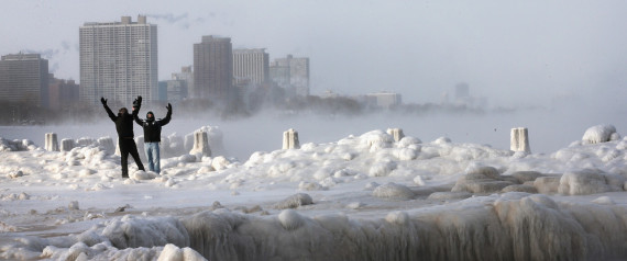
Published Sunday in the scientific journal Nature Climate Change, the study says that despite fears that global warming might lead to more cold weather extremes in places like North America – much-discussed during this winter's "polar vortex" – we're actually seeing the number of extremely cold weather days fall, not rise.
Screen found that winds that blow out of the Arctic from the north – they're responsible for the blasts of cold air that bring winter weather extremes in the U.S. – are warming up faster than winds that blow warmer air in from the south.
That reduces the difference in temperature between the two, which leads to less extreme weather and fewer extremely cold days, Screen told Mashable. "You're kind of taking the edge off of your cold extremes," he said.

At Least 12 Killed in Bulgaria after Torrential Rain and Flooding

At Least 12 Killed in Bulgaria after Torrential Rain and Flooding

Link: http://www.weather.com/news/bulgaria-flooding-20140620


At least 12 people – including 2 children – were killed in torrential rains and flooding in northeastern Bulgaria on Thursday. An unknown number of people remain missing.
In the Black Sea resort city of Varna, heavy rainfall in the city triggered a massive flood wave in the low-lying district of Asparuhovo, Reuters reports. The rush of water swamped streets and houses with mud and debris and left cars mangled and on top of each other. Roads in and out of the suburb were blocked and tens of thousands were without electricity. 
Interior Minister Tsvetlin Yovchev confirmed that ten bodies were recovered from in Varna and two more bodies were found in the northern city of Dobrich, where the River Suha burst its banks, according to the Associated Press. CNN reports that dozens are still missing.

A state of emergency was declared in Asparuhovo and rescue workers were helping to relocate flood victims to temporary shelters. The Bulgarian Red Cross was on the scene providing providing drinking water, food and essential supplies to victims.

Twin Cities Flooding Causes Mudslide Near University of Minnesota Medical Center

Twin Cities Flooding Causes Mudslide Near University of Minnesota Medical Center


Flooding woes continued to worsen in Minnesota Thursday night when a hill gave way along the Mississippi River in Minneapolis, forcing a road closure and evacuations from a nearby hospital.
Deputy Fire Chief Todd White tells the Star Tribune that the slide occurred around 7 p.m., sending a 100-yard swath of the bluff onto the road and river below. He says about 6 to 8 feet of mud were left on the West River Parkway, which was partially closed.
The mudslide comes after torrential rain and flash flooding in the area Thursday.
Minneapolis/St. Paul saw 4.13 inches of rain fall on Thursday, which set a daily rainfall record for any day in the month of June. The Twin Cities is also in second place for the wettest June with 10.76 inches, the record is 11.67 inches set in 1874. The Mississippi River at St. Paul is forecast to reach major flood stage this weekend, which could result in additional road closures.

Wednesday, June 18, 2014

EPA: Here's How Power Plants (Yes, Power Plants) Will Help Us Fight Global Warming

EPA: Here's How Power Plants (Yes, Power Plants) Will Help Us Fight Global Warming


In highly anticipated announcement Monday, the Environmental Protection Agency released the draft of a proposed rule that would make the first-ever significant reductions in greenhouse gas emissions from power plants nationwide, with a plan to cut their carbon emissions 30 percent by 2030.
Carbon emissions from coal-fired power plants – which today generate approximately 40 percent of the nation's electricity – are the proposed rule's main target. Coal is the most carbon-intensive fuel used for electricity generation, and releases roughly twice the emissions of natural gas, the next most widely used fuel.
Today's announcement is the beginning of a process that will take years before the rule is fully implemented. After today, a one-year period of public comment begins, followed by a June 2016 deadline for states to submit their plans to meet their emissions reduction goals.

Great Lakes Ice Free, At Last, in June!

Great Lakes Ice Free, At Last, in June!

By Jon Erdman,  Published: Jun 14, 2014, 9:02 AM EDT

The Great Lakes were finally 100 percent ice-free on June 10, according to the U.S. Coast Guard.

View image on Twitter
Lingering patches of ice in parts of southern Lake Superior in late May and early June were the most widespread on record for that time of year dating to at least the early 1980s.
June daytime air temperatures predominantly in the 60s and 70s, along with a handful of wet June days helped melt remaining chunks of floating ice.
Despite this, Lake Superior water temperatures continue to be quite cold, generally in the upper 30s and 40s. One of the coldest winters on record, followed by a persistently chilly spring, were the culprits for this persistent lake ice.

NASA Satellite Shows Two Stunning Atmospheric Phenomena off Baja California

NASA Satellite Shows Two Stunning Atmospheric Phenomena off Baja California


NASA's Aqua satellite snapped this image of a set of swirling eddies called von Kármán vortices and a rainbow-like optical phenomenon called a glory off the coast of Baja California on June 8, 2014. (NASA)

NASA’s eyes in the sky are important parts of weather-monitoring efforts, with satellites tracking hurricanes as they barrel across the ocean and storm systems as they sweep across the country. But sometimes they just find really cool stuff in the atmosphere.

The von Kármán vortices, named for Hungarian-American physicist Theodore von Kármán, appear as a set of eddies following each other in a line. To explain how they form, it helps to remember that air is a fluid, just like water. Just as a rock can perturb water flowing around it in a stream, an island or some other obstacle can perturb the clouds and air flowing over it.

The aptly-named glory happens when light from the sun is scattered backwards by water droplets in clouds. To an observer on the ground, they appear as a halo of rainbow colors directly opposite the sun in the sky. They are most often seen in thin clouds or fog from mountains or other high ground and from airplanes.

Cost of Natural Disasters Has Quadrupled in Recent Decades, Official Says

Cost of Natural Disasters Has Quadrupled in Recent Decades, Official Says


It's getting a lot more expensive to recover from natural disasters today than ever, according to a senior European official who urged world leaders Thursday to spend more on preparing cities and coastal regions for the impact of storms and other disasters to ensure a stable future.
Kristalina Georgieva, European Commissioner for humanitarian aid and crisis response, told a conference on disaster risk reduction and management of the Asia-Europe Meeting that costs related to natural disasters have increased from $50 billion a year in the 1980s to $200 billion in the last decade, an era when the United States has weathered the impact of storms like 2005's Hurricane Katrina and 2012's Superstorm Sandy.
In three of the last four years, disaster-related costs exceeded $200 billion.
She said only 4 percent of spending for natural disasters today goes to prevention and preparedness, with 96 percent spent on response. But, she said, evidence shows every dollar spent on prevention brings at least $4 in savings on damage.

Freak heatwave kills 4, hospitalizes 1,600 in Japan

Freak heatwave kills 4, hospitalizes 1,600 in Japan last week


Emergency services rushed more than 1600 people to hospital suffering from heat stroke and heat exhaustion due to a week of unseasonably hot weather through June 1, Japan's Fire and Disaster Management Agency said Tuesday.
According to the agency, temperatures in some areas in Japan soared to above 35 degrees Celsius, with the heatwave causing a preliminary total of 1,637 people to be rushed to hospital, with four of them dying from their symptoms.
The heatwave was still punishing Tuesday and showing no signs of abating, the meteorological agency said Tuesday, with temperatures hitting 37.8 C in the town of Otofuke in Hokkaido, Japan's northernmost prefecture.
The disaster agency confirmed Tuesday that more than 40 percent of those requiring hospital stays were aged 65 or older.

Twin tornadoes tear through Nebraska town; 2 dead

Twin tornadoes tear through Nebraska town; 2 dead
By Michael Pearson, Indra Petersons and Ed Payne, CNN
Link: 

The rare twin tornadoes that spun through on Monday night wiped out the town's business district, obliterated its fire station and ground 40 or 50 homes into rubble, Stanton County Sheriff Mike Unger said. 

As much as three-fourths of the town of 350 is gone, Unger said. Two people died during the storm -- one a 5-year-old. The second death -- a traffic accident -- was probably weather-related, Unger said.


"Major damage here in Pilger, Nebraska," shared CNN's Indra Petersons.

In Nebraska, severe weather also caused damage in the towns of Wisner, Stanton and Pender. All four communities are within about 40 miles (64 kilometers) of one another, about an hour and a half northwest of Omaha.


Back in Pilger, storm chasers captured dramatic video of the twin tornadoes tearing through the countryside. At one point, the twisters straddled a state highway.

"It was terribly wide," Marianne Pesotta told CNN affiliate KETV-TV. "I drove east (to escape). I could see how bad it was. I had to get out of there."


Chicago Just Had Its Coldest Winter In History. Here's Proof.


Chicago Just Had Its Coldest Winter In History. Here's Proof.

By Joseph Erbentraut | Posted: 04/02/2014 4:00 pm EDT

DEEP FREEZE

We knew it was a doozy, but new numbers make it official: Chicago's seemingly endless winter was also its coldest since records began in 1872.
According to a statement released Tuesday by the National Weather Service -- it was not, unfortunately, an April Fool's joke -- Chicago experienced its coldest four-month period on record between December 2013 and March 2014.
Though meteorological winter ended weeks ago, cold weather has not loosened its grip on the Windy City. The month of March was Chicago's 19th coldest ever, contributing to an average temperature of just 22 degrees over the four months -- the chilliest average temperature for that period since tracking began 142 years ago.


As Beaches Open, Lake Michigan Water Temps At Near-Record Lows For May

As Beaches Open, Lake Michigan Water Temps At Near-Record Lows For May


UK summer flash floods to become more frequent, study shows

UK summer flash floods to become more frequent, study shows
Fiona Harvey, environment correspondent
The Guardian, Sunday 1 June 2014 13.00 EDT

Boscastle
Flash flooding in summer is likely to become much more frequent across the UK as a result of climate change, with potentially devastating results in vulnerable areas, according to new research.
The study, published in the peer-review journal Nature Climate Change, is the first to draw a direct link between climate change and an increase in summer downpours.
The research, a result of a collaboration between the Met Office and Newcastle University, used climate change computer models and standard weather prediction models of the type used for short-term weather forecasts. It found that summers would be drier overall, but punctuated by more extreme downpours.
These can have a much worse effect than the steady rainfall typical of winter, because the dry land is less capable of absorbing water, and when too much falls in a short period it runs off, causing flash floods of the type that struck Boscastle in 2004, one of the worst examples of sudden localised flooding in recent years.
Elizabeth Kendon of the Met Office, the lead author of the study, said that the research was groundbreaking in using a high-resolution weather forecasting model to translate the likely effects of climate change into a detailed prediction of future UK summer weather.
"Until now, we haven't been able to do it in this way," she said. "This should help people to understand what is likely to happen in the summer in future. It's very important that we've detected this signal for heavier downpours in the UK. It's now for policymakers to decide what to do about it."
Some of the worst results could still be a few decades away, but the effects are already being felt and are likely to grow more severe, according to the models. But Kendon said more accurate predictions would depend on more scientific research being undertaken.

Utah forecast: A matter of fire and ice, snow and heat

Utah forecast: A matter of fire and ice, snow and heat


Link: 
http://www.sltrib.com/sltrib/news/58077832-78/utah-weather-fire-ice.html.csp

Northeastern Utah, ignoring stereotypical June, gets some of the ice, with a Winter Weather Advisory in effect until noon Wednesday in the northern and central mountains. 

Meanwhile, there was more of the fire aspect for the southern reaches of the state. Throughout southwestern and southcentral Utah, hot, dry conditions raised fire hazards. Southern winds reached 59 mph on Tuesday, according to NWS records.

source: 

Southern Utahns could expect high temperatures in the mid-80s Wednesday, a few degrees cooler than Tuesday’s temperatures.
The Utah Division of Air Quality rated the entire state "green," of healthy, with the exception of Washington County, which had a "yellow," or compromised air quality grade.
The Intermountain Allergy & Asthma website’s pollen index on Friday was "very high" only for grass, though mold and plantain earned "moderate" grades for allergens.

Powerful Storms Bring Tornadoes, Flooding to Great Lakes, Dakotas

Powerful Storms Bring Tornadoes, Flooding to Great Lakes, Dakotas
Published: June 19, 2014
Link: 
http://www.wunderground.com/news/powerful-storms-bring-tornadoes-flooding-great-lakes-dakotas-20140618

A line of powerful thunderstorms rolled through the Dakotas and Great Lakes region Wednesday, flooding roadways and damaging several homes and businesses.
In South Dakota, a tornado hit the small town of Wessington Springs, tearing "through the heart of town," around 8 p.m., according to National Weather Service meteorologist Todd Heitkamp. At least one person was injured. 
Wednesday's storms follow a three-day string of severe weather across the Northern Plans and Great Lakes. Additional thunderstorms are expected to develop in the Midwest and Central Plains on Thursday. 
Reports of significant damage across the Midwest:

Indiana

Authorities in northern Indiana responded to numerous reports of trees and limbs down on houses and cars after a severe thunderstorm storm with winds of up to 65 mph passed Wednesday afternoon, but there were no immediate reports of significant injuries or damage.There also were some isolated reports of half-inch sized hail. Indiana Michigan Power Co. reported more than 5,000 customers in DeKalb, Elkhart, St. Joseph and Allen counties were without power Wednesday evening.

Michigan

View image on Twitter

A fresh wave of severe thunderstorms has moved across Michigan, knocking out power to at least 65,500 homes and businesses and bringing heavy rains that caused road flooding. DTE Energy Co. says at least 40,000 of its customers lost power, while CMS Energy Corp. reports about 22,000 blackouts and Lansing Board of Water & Light about 3,500. Most are expected to have power back by sometime Thursday.

South Dakota

View image on Twitter

The National Weather Service says a confirmed tornado has directly hit a small town in Jerauld County. Warning coordination meteorologist Todd Heitkamp says law enforcement in Wessington Springs reported the tornado went right "through the heart of town." It hit just before 8 p.m.

Forecast for 2014: El Nino - and grain famine

Forecast for 2014: El Nino - and grain famine

By  Jun. 18, 2014 | 12:50 AM

Rice farmers in Indonesia 2011

Brace for it, world and Israel: Scientists are forecasting that another El Nino weather system will apparently develop this summer, leading to even more extreme weather events. The system might wait for winter in the northern hemisphere, the scientists add, but arrive it almost certainly will – and if it’s a bad one, it could lead to catastrophic crop failure. 

“Here in Israel, we concluded from studying previous years that anything can happen, from drought to torrential rainfall,” says Bruins, noting that while El Nino is a repetitive phenomenon, its strength and duration can’t be foretold. “The literature refers to weak, moderate and strong El Nino. A strong one can be highly unpleasant, causing things like devastating drought in Australia and Indonesia, and sometimes also in the United States. El Nino can even dry out India, weakening the monsoons,” says Bruins.

And that can have a trickle-down problem caused by what the professor views as a mistake by leading economists that could wind up costing many lives.

The problem is that the United States and Australia now supply most of the grain to the world. ”Some 105 countries depend on importing grain. We’re among them,” says Bruins. “Israel has to buy 90% of our grain from the world market. If El Nino hits hard, in India or China, and their crops diminish badly, it will be impossible for the U.S. and Australia, which will have droughts of their own, to supply the world with enough grain.”

India and China would buy up the world market and that would be that, he explains.


Record May Heat and Wildfires Continue in California; Extreme Flooding in Serbia

Record May Heat and Wildfires Continue in California; Extreme Flooding in Serbia

By: Dr. Jeff Masters , 2:13 PM GMT on May 16, 2014

More record May heat seared Southern California on Thursday, and fierce Santa Ana winds continued to fan nine wildfires in San Diego County. The fires had destroyed at least eight houses, an 18-unit condominium complex and two businesses and burned more than 15 square miles by Thursday evening, causing more than $20 million in damage. Los Angeles Airport hit 97° on Thursday, which is tied for the hottest May temperature on record, said the NWS in Los Angeles (note, though, that NOAA's Threaded Extremes website lists the all-time May record for LAX at 91°.) All-time record May heat was also recorded on Thursday at Santa Maria (105°.) In Downtown Los Angeles, the mercury hit 102° on Thursday, falling short of the all-time May record of 103° set on May 25, 1896. 


100% of California in severe to exceptional drought
Thursday's U.S. Drought Monitor report showed grim news for California: 100% of the state is now in severe or higher drought, up from 95% the previous week. Though just 25% of California is classified as being in the highest level of drought, "Exceptional", Erin McCarthy at the Wall Street Journal estimates that farms comprising 53% of California's $44.7 billion market value lie in the Exceptional drought area. During the most recent California rainy season, October 2013 through April 2014, the state received 10.44" of precipitation, which is just 51% of average for the period, and the third lowest such total on record. 

Already, the 2014 drought has cost the state at least $3.6 billion in agricultural damages, the California Farm Water Coalition estimates.

Video captures waterspout forming in Tampa Bay

Onlookers in Tampa, Fla., caught a spectacular weather show yesterday when a waterspout formed in Tampa Bay. The video shows the waterspout beginning to form.
According to WoodTV.com, the waterspout actually hit the shore and briefly became a tornado, damaging one home.
Station WTSP points out that Tampa Bay has the perfect ingredients for waterspout activity: “warm water, light winds, and high humidity.”
According to the National Oceanic and Atmospheric Administration, a waterspout is a combination of air and mist that forms into a funnel. Although they look cool, they can be as dangerous as tornadoes, especially ones that form during winter.
The ones formed during fair weather usually dissipate quickly once they hit land, as this one did.

Early Summer Heat Broils Northern Hemisphere

By: Christopher C. Burt , 9:06 PM GMT on June 10, 2014


While the summer has started off relatively cool for the eastern two-thirds of the U.S. many other locations in the world have been broiling the past several weeks. Record or near-record heat has been observed in portions of Germany, Switzerland, Austria, Russia, India, Nepal, China, Japan, Korea, Libya, Chad, and Mexico. Here’s a brief summary of the highlights.

An intense heat wave has developed in portions of Europe the past few days. On June 9th Ihringen inGermany reached 37.9°C (100.2°F). This was close to the all-time German national heat record for the month of June (which was 38.2°C/100.8°F at Frankfurt on June 27, 1947). This time, Frankfurt reached a sweltering 35.0° C (95.0°F), unheard of so early in the summer. Severe storms have broken out along the heat boundary in Germany and France with six storm-related deaths reported so far in Germany. A thunderstorm brought a 150 kmh (93 mph) wind gust to Dusseldorf Airport causing it to close for several hours. In France hail up to 8 cm (3”) in diameter fell in Ile-de France, Paris.


Map courtesy of ClimateCouncil.org.au

Mexico saw some amazing temperatures last week with a site in Sonora State called Moris reporting 51.5°C (124.7°F) on June 4th. This figure, however, is suspicious and not well verified by surrounding stations. A more believable 50.5°C (122.9°F) was registered at El Oregano on June 4th. This is just 1.5°C (2.7°F) short of Mexico’s all-time national heat record of 52.0°C (125.6°F) set at two sites in the Mexicali area in July 1995. The heat in northern Mexico brushed the U.S. Southwest during the first week of June. El Paso, Texas saw a string of four consecutive record-breaking days June 2-5 with a peak of 109°F (42.8°C) on June 3rd. This was the hottest temperature ever measured so early in the summer for the city.

Landslides, Heavy Rain, Flooding Threaten United States/Ghana World Cup Match in Natal, Brazil

Torrential rains have plagued the site of the opener, Natal—a coastal city of nearly 1 million people in northeastern Brazil—for three days, inundating streets, blocking off roads and triggering landslides that destroyed or damaged 20 to 40 homes and forced the evacuations of at least 50 people, according to local media. In response, the city declared a state of emergency Sunday, mobilizing emergency responders to deal with impacts from the heavy rain.

At least four other structures are threatening collapse at the site of the landslide. A retaining wall under pressure from the rain also collapsed in the city, enveloping six homes in earth, G1 reports. Multiple ponds and lakes are well past capacity and continue to spill over into the streets.
Nearly 9 inches of rain fell in Natal from 8 a.m. Saturday to 8 a.m. Sunday alone, according to INMET,Brazil's governmental meteorological department. But more than 13 inches are said to have fallen since the rain began Friday, first shutting down a FIFA-sanctioned fan fest at Fortress Beach in Natal, and then soaking the city's opening match between Mexico and Cameroon, NBC Sports reports.
http://www.wunderground.com/news/united-states-ghana-world-cup-match-heavy-rain-natal-20140615

Pilger, Nebraska Twin Tornadoes: How They Happened and How Unusual They Were

From that loop, it appears there were three separate tornadoes:
  • Tornado A first formed west of Stanton, Nebraska, then soon weakened north of Stanton as it curled toward the north.
  • Tornado B then formed east of Stanton and appears to have been the one that hit Pilger, Nebraska.
  • Tornado C then formed just southeast of the Pilger tornado, then wrapped northward tracking close to, or interacting with, tornado B.
According to tornado warnings and statements from the National Weather Service near Omaha, tornadoes from this supercell were sighted for at least one hour and 10 minutes from 3:46 p.m until 4:56 p.m. Central time, and continued for 30 minutes after the end of the radar loop above.
Supercell schematic
Schematic of a supercell's rear-flank downdraft and updraft.
The process of tornadogenesis in a supercell remains an active area of research, with the supercell's forward-flank downdraft (rain-cooled air), rear-flank downdraft (a surge of less cool, dry air at the western edge of the supercell) and low-level mesocyclone/updraft all possibly playing roles.
When the rear-flank downdraft surges and completely surrounds the updraft, cutting off warm, moist air, the first tornado will slowly fizzle and curl toward the left (for an east- or northeast-moving supercell). 
However, just to the southeast of the weakening tornado, a second tornado may form where the two downdrafts and the updraft meet. In this manner, you can have multiple tornadoes simultaneously form from the same storm: one typically weakening, while the other is maturing or strengthening.

http://www.wunderground.com/news/pilger-nebraska-twin-tornadoes-how-they-happened-20140617

Florida More Vulnerable to Tornadoes Than Midwest, Study Suggests

Though the findings mark 30 years of tornadoes, Florida has seen far fewer fatalities than several other states in recent years, which is making some meteorologists question the study's validity.
"From 2008 through June 16, 2014, there have been two tornado-related fatalities in Florida. In 2011 alone, 245 Alabamians lost their lives from tornadoes, and another 158 were killed in Joplin, Missouri, according to data from the Storm Prediction Center," said weather.com senior meteorologist Jon Erdman. "Florida's deadliest tornado outbreak claimed 42 lives in central Florida on Feb. 22-23, 1998."
Konrad's work makes sense and fits with earlier research on tornado fatalities, said Florida State University meteorology professor James Elsner and Barb Mayes Boustead, a National Oceanic and Atmospheric Administration meteorologist and tornado chaser.
Visibility is another problem for tornadoes in the Southeast. Because of atmospheric conditions, the region tends to get more tornadoes at night, making them harder to see, Konrad said. It also means some people may be asleep and miss warnings.
The South also has more trees and buildings to block the view of oncoming tornadoes, Konrad said. And they also tend to come from low-hanging clouds, making them harder to see.
Florida tends to get tornadoes more in the winter, while the Southeast tornado season is February through April, Konrad said. The Midwest generally sees them in the spring and summer.
http://www.wunderground.com/news/florida-midwest-tornado-study-20140617


Powerful Storms Bring Tornadoes, Flooding to Great Lakes, Dakotas

A line of powerful thunderstorms rolled through the Dakotas and Great Lakes region Wednesday, flooding roadways and knocking out power to thousands.
The storms will continue moving into the northeast Wednesday evening, bringing a threat of high winds to cities such as Pittsburgh, Charleston, W.V., and Washington, D.C.

Michigan

A fresh wave of severe thunderstorms has moved across Michigan, knocking out power to at least 65,500 homes and businesses and bringing heavy rains that caused road flooding.
DTE Energy Co. says at least 40,000 of its customers lost power, while CMS Energy Corp. reports about 22,000 blackouts and Lansing Board of Water & Light about 3,500. Most are expected to have power back by sometime Thursday.
Wednesday's storms knocked down trees and power lines and flooded roads. The National Weather service reports an 81 mile-per-hour wind gust at Adrian and says 1.71 inches of water fell in Washtenaw County near Ann Arbor in one 4-hour span.
They came a day after a funnel cloud briefly touched down in Iosco County in the northern Lower Peninsula, damaging buildings and vehicles.
http://www.wunderground.com/news/powerful-storms-bring-tornadoes-flooding-great-lakes-dakotas-20140618

Climate change now a mainstream part of city planning: Global survey


An increasing number of cities around the world now include preparations for climate change in their basic urban planning -- but only a small portion of them have been able to make such plans part of their economic development priorities, according to a unique global survey of cities released today.

The Urban Climate Change Governance Survey (UCGS), based on responses from 350 cities worldwide, underscores the extent to which city leaders recognize climate change as a major challenge -- even as they are trying to figure out how their responses can create jobs, growth, and cost savings in areas ranging from cities' transportation networks to their distribution of businesses.
"Climate change isn't an isolated issue," says Alexander Aylett, a postdoc in MIT's Department of Urban Studies and Planning (DUSP), and the lead author of today's report. "It has large implications for all other aspects of urban life. What we are seeing is cities starting to build it into the DNA of how they approach urban planning."
According to the findings, 75 percent of cities worldwide now tackle climate-change issues as a mainstream part of their planning, and 73 percent of cities are attempting both climate mitigation and climate adaptation -- that is, they are trying both to reduce emissions of greenhouse gases and to adapt to long-term changes that are already in motion. But only 21 percent of cities report tangible connections between the response to climate change and achieving other local development goals.
Aylett calls it a "cliché" that environmental and economic progress cannot coexist, citing a number of cities where jobs and growth have derived from climate-change efforts. Portland, Ore., he observes, developed incentives, training, and regulations to help sustainable construction firms grow, while a pilot program called Clean Energy Works Portland employed 400 workers to reduce home energy use, reducing carbon emissions by 1,400 metric tons annually.
Urban planners in Alberta, as Aylett notes, have studied the cost savings associated with limiting metropolitan sprawl and concluded that denser development could save $11 billion in capital costs over the next 60 years, and $130 million in annual maintenance. But most cities, he suggests, have simply not yet identified ways to link climate planning and economic development in the first place.
"It isn't so much that it's hard to reconcile economic and environmental priorities," Aylett says. "It's that we're not trying."

http://www.sciencedaily.com/releases/2014/05/140529092812.htm