Showing posts with label Evelyn Arthur. Show all posts

Thursday, November 16, 2017

Sea Fog over the Lake

Last December, many Chicagoans woke up to see wispy layers of fog rolling off of Lake Michigan. This is a fairly common weather event that happens when a mass of very cold air blows over warmer water, often called arctic sea smoke or sea fog. On this particular day, the air above the lake was 3 degrees and the water was 35 degrees.

When the cold air blows over the warm water, the water near the surface evaporates into the colder air above and increases the humidity in the air. When the air reaches its dewpoint, the vapor condenses into fog.

This phenomenon really only happens when there are strong winds driving the colder wind out over the lake. This weird effect can happen even if Lake Michigan is covered in ice .


http://www.chicagotribune.com/news/local/breaking/ct-lake-michigan-arctic-sea-smoke-htmlstory.html

Arctic sea fog

Tuesday, November 14, 2017

Shelf Clouds

Shelf clouds, also called arc clouds, are typically seen at the leading edge of a squall line of thunderstorms. Although they might look similar, shelf clouds are nothing like tornadoes; what you see in a shelf cloud is the boundary between the downdraft and the updraft of a thunderstorm. Rain-cooled air descends in the downdraft then spreads when it reaches the earth's surface, then warmer, moist air is lifted at the gust front of the rain-cooled air. When the warmer air condenses, a shelf cloud forms.

Shelf clouds, after they have passed, can cause strong wind gusts and heavy rain or hail. These wind gusts can be so strong that they are able to knock over trees and power lines.


https://weather.com/science/news/shelf-cloud-photos-20130412


Shelf cloud, Bozeman, Montana

Thursday, November 9, 2017

Brinicles-The "Icicles of Death"

A brine icicle is an icicle that forms deep beneath the ocean, often called a brinicle. When sea ice is created in the Arctic and Antarctic ocean, impurities like salt are forced out, this makes the ice that is formed less salty than the water from which it was formed. As the salty water leaks into the surrounding water, it becomes denser. This prevents the water from freezing to the ice and causes the ice to sink. As the ice sinks and reaches warmer water below, the water freezes around it and creates the descending tube of ice called a brinicle.

These weird phenomena are called "icicles of death" because once the ice reaches the seabed, a web of ice forms aroung it and spreads across the ocean floor, freezing everything it touches. This includes any sea life it finds, including star fish and sea urchins which are common animals found on the sea floor.

https://www.mnn.com/earth-matters/wilderness-resources/stories/brinicles-what-icicles-death


Image result for brinicles

Tuesday, November 7, 2017

Fallstreak Holes

Fallstreak Holes, or their much cooler name: hole-punch clouds, are large gaps that appear in cirrocumulus or altocumulus clouds. Often reported as UFOs, these gaps occur when sections of supercooled water droplets in a cloud freeze into ice crystals and fall below the cloud, leaving a hole. Many times, this sudden freezing is caused by a passing plane overhead.

These holes can get up to 50km across within an hour of the first droplets falling.

http://www.weather.gov/arx/why_fallstreaks

Image result for fallstreak hole

Wednesday, November 1, 2017

Sun and Moon Dogs

Sun dogs, also called Parhelion, are patches of light that appear beside the sun. They usually appear as colored areas of right to the left or right of the sun, typically 22 degrees distant and at the same horizontal position as the sun. They can also form as halos or rings around the sun. It is speculated that they are called Sun Dogs because they follow the sun like a dog follows its owner. These weird weather phenomenon are formed by the light that passes through hexagonal ice crystals in high and cold cirrus clouds. As the crystals sink, they become vertically aligned and refract the sun horizontally.

There can also be Moon Dogs that appear beside the moon. These are formed by lunar light passing through ice crystals. Moon dogs, also called paraselenae, aren't as common as sun dogs are because the moon has to be particularly bright for them to show and they can only happen at night.


Image result for sun dogs


https://www.livescience.com/26402-sundogs.html

Tuesday, October 31, 2017

Relampago del Catatumbo

In Venezuela, where the Catatumbo River meets Lake Maracaibo, there is a perpetual lightning storm. Anywhere from 140 to 160 nights out of the year, for up to 10 hours at a time, the sky over the river is covered by a lightning storm. It is known to produce up to 280 lightning strikes per hour and is nearly soundless.

Called the “Relampago del Catatumbo” (which literally means “The lightning of the Catatumbo”) it was first referenced in 1597 in a poem by Lope de Vega. The poem talks about Francis Drake’s attempt to take the city of Maracaibo in the middle of the night in 1595, only to have his position given away to the city’s defenders by the constant lightning.

The lightning is so regular that it is often used as a navigation aid to many ships and is known among sailors as the “Maracaibo Beacon”. Although there has been many theories for the lightning in the past, scientists are now able to attribute the lightning to a regular, low lying air current that comes from the Caribbean.


Image result for Relampago del Catatumbo

Wednesday, October 25, 2017

Snow Rollers, Nature's Natural Snowballs

Snow Rollers are rare and weird weather phenomenon that occur during the winter in many areas but are most commonly seen in hilly or mountainous areas. Often referred to as "nature's natural snowballs", these barrel-sized snowballs occur when strong winds pick up wet snow and blow it along the ground, resulting in a cylinder of snow that it hollow in the middle. When the snow roller becomes too big for the wind to move it, it stops.

According to the National Weather Service, the optimal conditions for snow rollers to form is a layer of ice, then a layer of loose, wet snow accompanied by strong winds and a slope to the ground.

Image result for snow rollers


https://weather.com/tv/shows/strangest-weather/video/snow-rollers

https://weather.com/news/weather/news/snow-rollers-idaho

Tuesday, October 24, 2017

Light Pillars and How They Form

Light pillars are a weird weather phenomena that can be seen all over the world. The conditions have to be just right for them to form, extremely calm and cold with no wind, temperatures usually 10 or 20 degrees below zero. The pillars are caused by light, usually from sources such as street lamps, reflecting off of the ice crystals in the air but only if the ice crystals are close to the ground.

Light pillars are not synonymous with storms, if a storm were to form at the same time that light pillars were evident, the storm system would disrupt the ice crystals and the pillar of light would disappear. Although it's simple to predict when conditions are going to be cold and without wind, it is difficult to predict when ice crystals are going to present in the air and close to the ground, making light pillars relatively hard to predict. These spectacles of light are most commonly seen in the northern US and Canada.

https://www.accuweather.com/en/weather-news/photos-what-are-light-pillars/70000673

Image result for light pillar

Thursday, October 19, 2017

The Fjords of Norway

When tourists visit Norway, the first thing they go visit is the Fjords. Fjords are long and narrow bodies of water reach far inland and are fairly deep. They are often set in a U-shaped valley with steep walls of rock stretching up on either side. Although Norway is famous for its Fjords, they can also be found in New Zealand, Chile, Canada, Greenland, and Alaska.

The fjords were formed by glaciers at the end of the last ice age through a process called glaciation. The glaciers moved through the area, carving deep valleys into the land; when the glaciers melted, the fjord were formed, creating the beautiful landmasses that can be seen today.

Some fjords also have coral reefs at the bottom that teem with plankton and sea anemones, these are called cold-water reefs and are often completely dark and under high amounts of pressure due to the depth of the water. Fjords like these also have rock islands called "Skerries".

https://www.nationalgeographic.org/encyclopedia/fjord/


Tuesday, October 17, 2017

Ophelia Turns the Sky Red


A few days ago, in the United Kingdom, the sky was red, yellow, and orange. Citizens could see a yellow haze hanging over the city and the sun had turned bright red. The clouds held an orange glow and some even reported smelling sulfur heavy in the air. Many areas were forced to turn on the street lights in the middle of the day due to the lack of vision.

These events have been attributed to Hurricane Ophelia rolling in, bringing in dust and tropical air from the Sarahan Desert, carried by string winds from Africa. Met Office forecaster explained it as, "the eastern side of the low pressure system air coming up in the southern direction...air is being pulled from southern Europe and Africa and that air contains a lot of dust." This dust was dragged high up into the atmosphere where the light from the sun was scattered in longer wavelengths, which is the red part of the spectrum, which is why the sun appeared red to many people's eyes.

Those with asthma were advised to stay indoors to avoid any health problems.

http://metro.co.uk/2017/10/17/why-was-the-sun-red-how-ophelia-caused-the-weird-weather-phenomenon-7005621/

http://www.telegraph.co.uk/news/2017/10/16/strange-red-sun-phenomenon-seen-across-england-caused-hurricane/

South West London turned a hazy orange and red as Ophelia bought across Saharan dust

Wednesday, October 11, 2017

Fish Showers

Earlier this year in Tampico, Mexico it rained fish. During a thunderstorm, fish began falling from the sky and landing at the feet of townpeople. The fish were small, only a few grams each, but were still startling changes from what the people of Tampico were used to.

Although this is a weird phenomena, there are multiple cases of this happening in other places.  In many cases the fish, and sometimes frogs, were sucked up by strong winds, usually from tornadoes or hurricanes, and moved other places where they fell from the sky. In other cases, tornadic waterspouts are thought to be the causes of raining fish. These waterspouts consist of a low-pressure central vortex surrounded by a rotating funnel of updrafts, the central vortex is strong enough to suck up water and small objects like a vacuum. When the waterspout loses energy, the things it is carrying are deposited back onto the earth.

https://www.loc.gov/rr/scitech/mysteries/rainingfrogs.html

http://www.npr.org/sections/thetwo-way/2017/09/28/554242564/it-rained-fish-in-mexico-authorities-say-no-its-not-the-end-times-we-think

Original image

Tuesday, October 10, 2017

Slope Point, New Zealand

Slope point is the most southerly spot on New Zealand's South Island. It is here that that they get cold, southwesterly winds from the antarctic ocean, these winds are interrupted which gives them lots of power before they hit the island. This can be seen through the trees that were planted there by sheep farmers, originally planted to give the flocks protection from the extreme weather, now bending over from the wind.

Due to the severe winds, these trees are now all permanently slanted, stretching to the side rather than upwards. Unsurprisingly, no one really lives here other than a few sheep and a few sheep farmers.


http://www.atlasobscura.com/places/slope-point

Thursday, October 5, 2017

The Dust Bowl

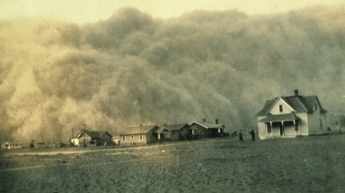
In the 1930s, the United States was plagued by the Dust Bowl, a dust storm that swept over the whole country. At the beginning of the 20th century, many new and inexperienced farmers moved to the great plains and started farms. They would plow up the land in order to plant wheat and corn. When the great depression hit, wheat prices went way down and farmers were forced to plow up more land to harvest more crops and break even.

In 1931, a drought began in the southern plains and without the deep rooted prarie grasses to keep the soil in place, the topsoil began to get blown around. This led to the Dust Bowl, a series of severe dust storms that darkened the sky and covered everything in a layer of grime.

These dust storms would get into homes through cracks in windows and doors, covering furniture and people in dust. Many people developed "dust pneumonia" after inhaling too much dirt, this included chest pain and difficulty breathing, many people died from this condition as well. Some of these dust storms carried topsoil all the way to Washington D.C. and New York. These dust storms also brought great amounts of static electricity, built up between the ground and the airborne dust. This surplus of static electricity could short out engines and car radios and knock people shaking hands to the ground. Overall, the dust bowl lasted about a decade, killed hundreds of people, and left thousands of people homeless.

Image result for dust bowl


http://www.history.com/topics/dust-bowl

http://www.history.com/news/10-things-you-may-not-know-about-the-dust-bowl

Tuesday, October 3, 2017

Ball Lightning

Ball Lightning is a weird and interesting weather phenomena that happens very rarely. It usually happens during thunderstorms and it lasts for about a second, this is a long time of exposure for a lightning bolt. Ball lightning appears as a big flash of light that is circular, sometimes it has a blue glow and can still come off of things like lightning rods. It ranges in size and can be any color.

Scientists believe that when lightning hits something, it blasts a cloud of highly energized nanoparticles into the air. When the nanoparticles wear down, they emit a ball of light. This is just a popular theory, though, as scientists are still trying to learn more. Another theory is that when organic matter decays, like in marshes or wetlands, it releases methane and other gases that spontaneously catch fire after encountering oxygen in the air.


http://nautil.us/blog/a-new-explanation-for-one-of-the-strangest-occurrences-in-nature-ball-lightning

https://weather.com/news/news/ball-lightning-seen-first-time-20140120

Wednesday, September 27, 2017

Firenadoes Sweep San Diego

In the spring of 2014 San Diego was hit by dozens of wildfires that rages throughout the hills. Over 14,000 acres of the San Diego countryside were burned, forcing thousands to evacuate and leaving many homes destroyed. One thing to come out of these deadly wildfires was a fire tornado or "firenado".

These "firenadoes" are immense spires of whirling flames that resemble tornadoes. Despite the name, these strange weather phenomenons aren't tornadoes at all. They are created by the hot, dry air rising quickly from the ground as opposed to the conditions that cause tornadoes; moist air close to the ground, atmospheric instability, and clashing air fronts. When this hot air rises from the ground, it creates vertical "chimneys" and as more hot air is pulled in, it begins to swirl in a vortex. The vortex is created by the angular momentum of the air.This vortex then picks up burning embers, flammable debris, and ash turning it into a dangerous tower of flame.

Most fire tornadoes only last a few minutes. When the hot air rises and cools, the strength of the vortex decreases and the fuel burns out. Despite this, fire tornadoes can get to 2,000 degrees Fahrenheit and extend hundreds of feet into the air.

https://www.livescience.com/45676-what-is-a-firenado.html


Tuesday, September 26, 2017

Red Dust Storm Covers Australia

In September of 2009, the cities of Sydney and Brisbane, Australia were covered in blankets of red dust. The dust rolled in the night of the 22nd and made left an orange glow the morning of the 23rd when people began to wake up, turning the whole sky red. The dust had come from the Lake Eyre basin in Queensland, which had become parched from a severe drought. The dust was picked up by strong winds and carried miles in every direction.

Unfortunately, this phenomenon led to many health issues around Australia, many people had to be hospitalized because they could not breathe, especially those with asthma. The New South Wales Department of Climate Change and Weather claimed that the particle concentration in Sydney's air was the highest on record. It also led to many flights at the Sydney airport having to be delayed and all of the inbound flights had to be diverted due to the lack of sight from the dust.


http://news.nationalgeographic.com/news/2009/09/090923-australia-red-dust-video-ap.html


Image result for australian red dust storm

Thursday, September 21, 2017

Deadliest Hurricane, 1900

In 1900, a category 4 hurricane slammed into the city of Galveston, Texas. The damage was astonishing; 3,600 buildings destroyed by winds over 135 miles. Storm surges got up to 15 feet and up to 12,000 people died. The reason that there was so much damage was because the Weather Bureau in Washington had predicted that the storm would pass over Florida and move up to New England, which was really wrong.

At this time, the Weather Bureau, which later became the National Weather Service, was only 10 years old and wasn't very advanced. The bureau's director had shut down communication about weather between Cuba and the united States and told U.S. forecasters that they had to go through Washington in order to issue a hurricane warning, which just made everything more difficult. The regional meteorologists realized that the storm wasn't going to pass them too late and did not have enough time to warn the city.

In the wake of the Galveston Hurricane, the Weather Bureau opened up communication channels, both internationally and within the US. It is because of devastating storms like Galveston that we have such a reliable weather predicting service now.

http://www.history.com/news/how-the-galveston-hurricane-of-1900-became-the-deadliest-u-s-natural-disaster


Library of Congress image of Galveston hurricane damage

Tuesday, September 19, 2017

Hurricane Katrina, A Storm for the Ages

Hurricane Katrina is quite possibly the United State’s most popular hurricane ever. Katrina started out as a tropical depression when it showed up southeast of the bahamas then worked its way up to a tropical storm, and then a hurricane. By the time Katrina made landfall in Louisiana, it was a category 5 hurricane. The damage it left was wildly devastating to multiple communities.

The official death toll of Katrina is 1,836 casualties, with 1,577 from Louisiana and the rest all coming from surrounding states in the south. Katrina also left behind roughly $108 billion in damage and millions of people homeless. After Katrina, many newer, better, ways to evacuate and alert the public were created as well as a new and improved levee system.


Wednesday, September 13, 2017

Six Feet of Sea Foam

On June 5, 2012, the banks of Lorne, Australia were covered in 6 and a half feet of foam. The foam had started to show up the day before but reached its peak by June 5th. The foam is created by the breakdown of algae that grows in the water and on the beach; when the algae would breakdown, it would release air bubbles. The days leading up to June 5, there was also heavy rainfall that washed a lot of dirt and nutrients into the sea. This, the air bubbles from the algae, and the combination of rough sea wind and the rolling tide, lead to massive amounts of foam. This is a once in every three to five year phenomena. Tourists and surfers alike spent the day playing and body-surfing in the massive amount of foam.


Tuesday, September 12, 2017

Seattle Has 56 Dry Days in a Row.

On August 12, 2017, Seattle Washington finally got some rain after 56 days straight of having no rain at all. This streak broke their previous record of 51 days and baffled the population of Seattle. Seattle usually gets an average of about 38 inches of rain every year, the second highest in the country. That comes out to about 152 rainy days a year. The last record streak, 51 days, was set in 1951 and the second highest streak, 48 days, was set in 2012. 2017’s rainless streak was also accompanied by 3 days in a row of record breaking temperatures, getting over 90 degrees. As a reference, Seattle’s average temperature in August from years past was typically between 74 and 78 degrees.


A man races away as a jet begins to spray him at the International Fountain at the Seattle Center during a heat wave Aug. 2. (Elaine Thompson/AP)