So what role, if any, is the polar vortex truly playing in the chilly conditions across parts of the Midwest and East this April?
What Is Polar Vortex?
The polar vortex is an area of low pressure in the upper atmosphere, primarily in the stratosphere, a layer of the atmosphere above which most of our sensible weather occurs (known as the troposphere).

The polar vortex is strongest in winter,
thanks to an increased temperature contrast between the polar regions and the
mid-latitudes, including the United States.
How It Works
When the polar vortex is strongest,
you're less likely to see cold air plunge deep into North America or Europe.
(By strongest, we mean the generally west-to-east flow around the vortex is
stronger than average). The easiest way to conceptualize this is in terms of a wall. A
stronger polar vortex effectively helps to wall off cold Arctic air from the
mid-latitudes. Occasionally, though, the polar vortex is disrupted and
weakens. This happens when the stratosphere warms. When the polar vortex is weakened a piece of the polar vortex
can surge farther south, bringing Arctic cold into portions of North America
and Europe.
How It Impacts Your
Temperatures
Below-average
temperatures, along with snowy conditions, have been the story so far for much
of the Midwest and Northeast. This weekend, another shot of Arctic air will
bring potentially record cold temperatures to portions of the East. Colder-than-average
temperatures are expected for the Midwest, Northeast and parts of the South
beginning late this week and continuing into at least part of next week. One
of the causes of this temperature change is the weakening of the stratospheric
polar vortex that took place in March of last year. In response to the atmospheric
conditions, both the Arctic Oscillation (AO) and the North Atlantic Oscillation
(NAO) are expected to trend negative into at least mid-April. In addition, a strong,
blocking high pressure aloft near or over Greenland, referred to as a Greenland
block, is expected to develop. The negative AO and NAO conditions, along
with the Greenland block, will help to keep the cold conditions in the East
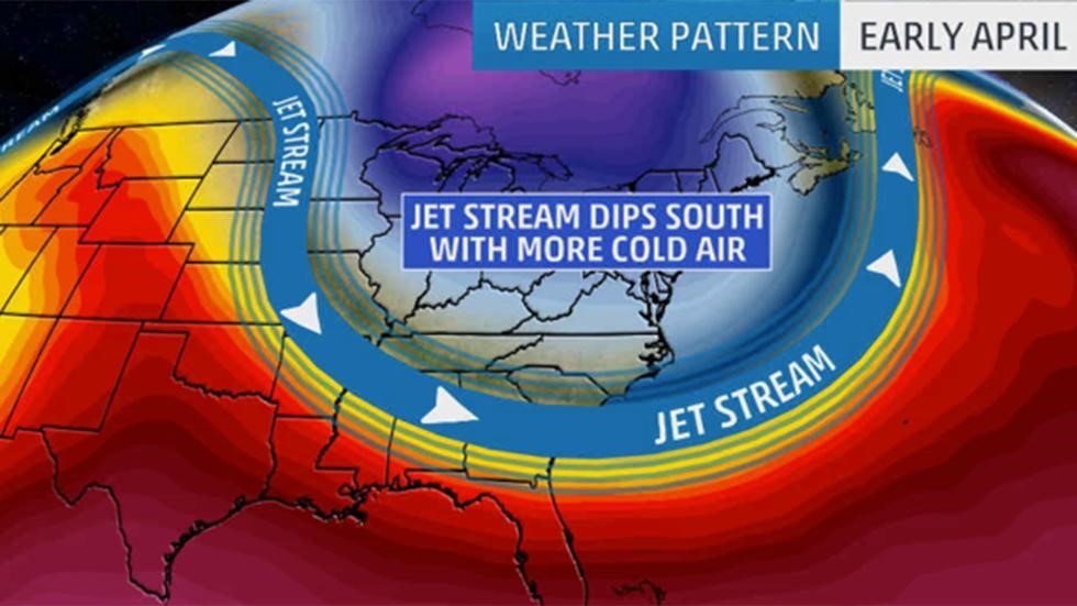
into at least mid-April. Meanwhile, lower in the atmosphere at jet-stream
level, a sharp southward plunge of the jet stream will once again surge
southward into the East late this week, accompanied by another round of
colder-than-average temperatures.
No comments:
Post a Comment