Wild weather to continue to batter eastern Australia in lead-up to Christmas
More storms, hail and rain expected as low pressure system brings unusually tumultuous weather
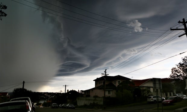
Unusually tumultuous weather has swept parts of eastern Australia over the past week, with meteorologists warning that further storms, hail and rain are likely to return in the lead-up to Christmas.
A severe thunderstorm battered Sydney on Sunday, leaving more than 10,000 homes without power as large hailstones rained down on parts of the city. Flights from Sydney airport were cancelled while the Tropfest short film festival was delayed after its venue in Centennial Park was evacuated.
In Melbourne, lightning lit up the sky early on Saturday morning, with a thunderstorm preceding a weekend of gloomy weather for the Victorian capital.
The storms come as Brisbane residents clean up from a “supercell” storm that caused damage that could cost up to $1bn. Hail damaged nearly 2,000 homes, while fallen trees have caused a problem for many households.
Last week, Darwin suffered a widespread blackout for around five hours following lightning strikes.
The wild weather, at a time when many Australians would be expecting calm, sunny days, is a result of two merging fronts, according to the Bureau of Meteorology (BoM).
A broad area of low pressure, stretching from central Australia to the south-east of the country, has been supplemented by a surge in humidity from tropical areas.
“That combination has led to an unstable environment in the atmosphere,” Craig Burke, a BoM meteorologist, told Guardian Australia. “Other local effects come to play, but the overall weather pattern is unsettled and it has been stagnant for the past week now. It’s unusual that this weather has persisted for a week.”
Burke warned that while there will be a short respite, the low pressure system will return later this week, which could bring further storms.
“This system isn’t going to disappear and it’s going to be reinforced by another weather system approaching from the west,” he said. “We will have a rainfall scenario for the second part of this week. If you’re expecting it to be sunny, that won’t be happening over eastern Australia.”
Inland Queensland, the Northern Territory, New South Wales and eastern Victoria are expected to see the worst of the returning showers and storms.
The wild weather follows what was Australia’s hottest spring on record. The average temperature of 24C exceeded the long-term average, taken from 1961 to 1990, by 1.5C, according to the BoM.
The world is on course for its hottest year on record, with the World Meteorological Organisation reporting last week that 2014 will eclipse 2010, 2005 and 1998 as the warmest year if November and December maintain the trend measured so far this year.
“We’ll have to wait for the figures, but we certainly had our hottest spring here in Australia,” Burke said. “There are exceptions – they had one of the best ski seasons in 30 years in NSW for example. But when you look at the whole pattern, it has certainly been a warm one.”
http://www.theguardian.com/weather/2014/dec/08/wild-weather-continue-batter-eastern-australia
No comments:
Post a Comment