What a difference a month can make! Since my last post, the tropical Pacific has changed gears, and now forecasters think there’s a 70% chance that La Niña conditions will develop this fall. However, any La Niña that develops is likely to be weak, and forecasters aren’t quite as confident that La Niña conditions will persist long enough to be considered a full-blown episode, giving it a 55% chance through the winter.
Ch-ch-ch-changes
When I wrote last month, the tropical Pacific wasn’t giving us much evidence that the atmosphere was responding to the slightly cooler-than-average ocean surface, and most of the computer models were predicting that sea surface temperatures would head back toward average.
Remember, La Niña (just like El Niño) requires action in both the ocean and the atmosphere. During La Niña, the ocean surface in the central and eastern tropical Pacific gets cooler than normal, leading to sinking air and less rain above that region, just as the waters near Indonesia get warmer and cause more rising air and rain. This stronger Walker Circulation is completed by stronger east-to-west surface winds and west-to-east upper level winds.
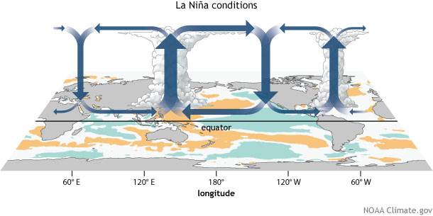
This atmospheric circulation works to enhance the cooler ocean surface, both by blowing across the surface just like you’d cool the surface of your coffee, and also by causing cold water from the deep ocean to rise up. Have you ever blown on the surface of a cup of coffee that has cream in it, but hasn’t been stirred up? You’ll see the cream rise up to the surface, brought there by the circulation you’ve created.
No comments:
Post a Comment