1. Birds Trapped in Hurricane Hermine
The birds were detected using differential reflectivity from NOAA's Dual-Polarization radar. This particular radar feature can be used to detect non-meteorological radar echoes such as birds and insects, in addition to its normal precipitation detection function.
We've seen this occur one other time in recent years during another U.S. hurricane landfall. Birds were detected on radar in the eye of Arthur as it moved near the coast of North Carolina in 2014.
Base reflectivity (left) and Di 2. Mayfly Hatch
This happened most recently on the evening of July 26, 2016, where it usually does right along the Mississippi River near the Minnesota and Wisconsin border. The mayflies often emerge in enormous numbers, allowing radar to detect them.
You can see the recent hatch in the image above in the green echoes from near the label for the city of La Crosse southward along the river.
3. The Bat Signal
This image was posted by the National Weather Service (NWS) in San Antonio, Texas, on June 13, 2016 with a caption "The Bat Signal is strong tonight!"
Each circle on the map shows an emerging bat colony detected by radar as they depart for the evening to feast on insects. This is a common summertime occurrence in central Texas.
4. Swarming Termites
The above image posted by the National Weather Service in New Orleans on the evening of May 29, 2016. In that radar image, termites can be seen swarming near the Big Easy, captured in the shades of dark blue and light green. The image was part of a radar loop that was posted to the NWS office's Twitter account.
5. Birds Along Nebraska's Platte River
This radar image from March 2, 2016, shows birds that were observed by radar along the Platte River in Nebraska. The birds are represented by the green and blue shadings near the red line, which is Interstate 80 along the Platte River in central Nebraska. Video taken the previous day verified the existence of a large number of sandhill cranes in the area, according to a Facebook post by the Rowe Sanctuary.
6. Monarch Butterfly Migration

(National Weather Service Reno, Nevada)
The NWS office in Reno, Nevada, posted to Twitter on March 27, 2015, the radar image above that shows the spring migration of Monarch butterflies. These butterflies were spotted using a differential reflectivity scan, which is typically used to identify different types of precipitation, hail size and tornadic debris. As shown in the example above, it can also identify non-meteorological echoes such as birds and insects. In this case, the NWS says the differential reflectivity shows objects that are much wider than they are taller, or what you would expect from the body type of a butterfly.
7. Birds Migrating
Tom Niziol, winter weather expert at The Weather Channel, captured this radar image of migrating birds in western New York on the evening of April 12, 2012.
Niziol says, "On the animation above I have penciled in what I describe as 'bird front' to outline the leading edge of the bird migration as it heads from the south shores of both Lakes Erie and Ontario across the water just after sunset."
You can read Tom's full article on this subject here.
8. Departing Train
Watch closely. Now, watch it again. That brief red streak moving to the northwest is actually a train leaving a terminal. The NWS office in El Paso captured it on its radar.
This is similar to how radar detected the interstate traffic earlier in this article.
9. Military Exercises
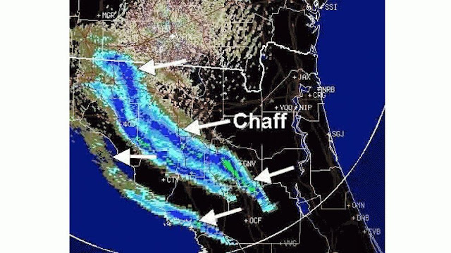
This image from the NWS office in Jacksonville, Florida, shows chaff in the narrow bands of green and blue radar echoes. Chaff are small pieces of aluminum which are released by military aircraft for self-defense to avoid radar detection.
10. Wind Farm Interference

Turbines from the Bulter Ridge wind farm in Wisconsin mess with radar data.(NWS Milwaukee/Sullivan)
Energy created by wind farms can mess with radar results. The Butler Ridge wind farm west of Milwaukee is one example. According to NWS Milwaukee/Sullivan, turbines stretch about 400 feet into the air, and sit within the line of sight of the NWS doppler radar in Jefferson County, Wisconsin.
"A small part of the electromagnetic energy radar beam sent from the radar is reflected back by the rotating turbines," the NWS said. "The radar processes this 'returned energy' as an area of precipitation and plots it accordingly on the map," which you can see circled in yellow.
(Source - https://weather.com/science/news/radar-hermine-birds-eye)
(Source - https://weather.com/science/news/radar-hermine-birds-eye)


No comments:
Post a Comment