The map shows Arctic sea ice concentration as of September 10, 2016. Areas with at least 15% ice cover appear in shades of gray-blue to white. Open ocean water (less than 15% ice cover) is navy blue. The yellow line shows the median (middle of the range) sea ice extent for 1981–2010.
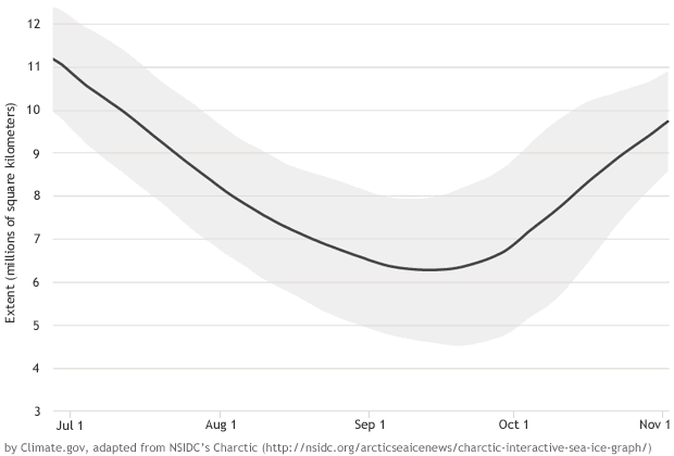
Arctic sea ice generally grows from late September through late February or early March, and melts from March through September. Sea ice minimum and maximum extents don’t coincide with the peak of summer and winter because the ocean is slower to warm up and cool down than the atmosphere.
The animation above shows changes in the yearly cycle of Arctic sea ice extent from 1979 (the first year of continuous satellite data on global sea ice cover) through September 13, 2016. The black line is the 1981–2010 average, and the gray band around it is the normal range of variability (plus or minus two standard deviations) for the same period. Yearly extents are color-coded by decade: 1979–1989 (green), 1990s (blue-purple), 2000s (blue), and 2010s (pink). This animation is adapted from NSIDC’s Charctic interactive sea ice graph.
No comments:
Post a Comment