Showing posts with label Abigail Arriaga. Show all posts

Tuesday, December 3, 2019

East Africa Floods Persist, Killing at Least 250

Rainfall from October to mid-November was as much as 300% above average across the Horn of Africa, according to the Famine Early Warning Systems Network. The areas hit hardest include parts of Ethiopia, Somalia and Kenya, where most of the deaths have occurred.

In some areas, the floods came on the heels of a drought that wiped out crops and livestock and left more than 50 million people facing a food shortage.

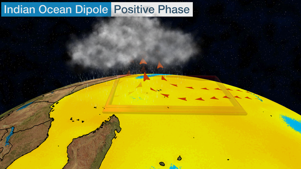
In October, water temperatures spiked off East Africa, sending the IOD to its third-highest value on record, behind only 1994 and 1997, according to Michael Ventrice, atmospheric scientist at The Weather Company, an IBM Business. That positive IOD leads to more evaporation off the warmer ocean water, which turns into rain.

"This is basically the Indian Ocean's version of El NiƱo, measuring the difference in water temperatures between the western Indian Ocean near Africa and the eastern Indian Ocean south of Indonesia,"  weather.com senior meteorologist Jonathan Erdman explained.


https://www.wunderground.com/article/news/news/2019-12-03-africa-flooding-deaths-kenya-somalia-sudan-ethiopia

Climate change is forcing one person from their home every two seconds, Oxfam says

People are seven times more likely to be internally displaced by floods, cyclones and wildfires than volcanic eruptions and earthquakes, and three times more likely than by conflict, according to the report released Monday.

This makes the climate the biggest driver of internal displacement for the period, with the world's poorer countries at the highest risk, despite their smaller contributions to global carbon pollution compared to richer nations.

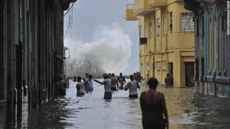
Hurricane Irma left flooding in its wake after hitting Cuba in September 2017.

For example, floods affecting agricultural land in low lying coastal areas can leave it unusable for farming, pushing inhabitants to leave the area for good.


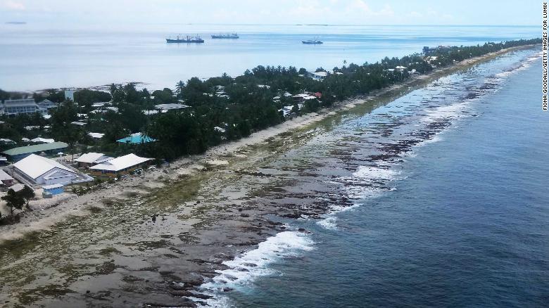
Islands like Tuvalu are particularly badly affected by climate-fuelled internal displacement.
Small island developing states (SIDS), such as Cuba, Dominica and Tuvalu, are particularly badly affected, making up seven of the top 10 countries with the highest rates of displacement from extreme weather disasters between 2008 and 2018.
People living in SIDs are 150 times more likely to be displaced by extreme weather disasters than those living in Europe, according to the report, which analyzed 2008-18 data from the Internal Displacement Monitoring Centre.


https://www.cnn.com/2019/12/01/world/oxfam-climate-displacement-intl-scli/index.html

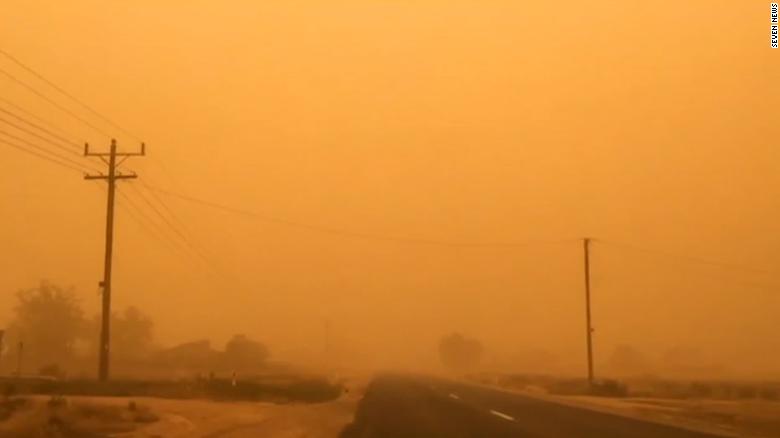
A massive dust storm has turned an Australian city red

The dust hit the city around midday with winds measuring up to 40 kilometers per hour (about 24.8 miles per hour) and temperatures hitting nearly 40 degrees Celsius (104 Fahrenheit), according to CNN affiliate 7News.

The dust storm was exacerbated by strong winds and high temperatures.

According to the Bureau of Meteorology, visibility at the airport fell from four kilometers (about 2.5 miles) to 500 meters (0.3 miles).


https://www.cnn.com/2019/11/21/australia/australia-dust-storm-intl-hnk-scli/index.html

Friday, November 1, 2019

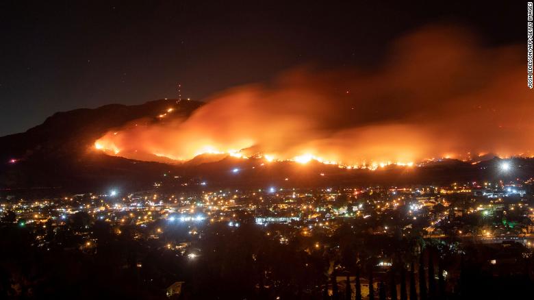
Wind gusts reach hurricane force as wildfires torch Southern California


Hurricane-force wind gusts of 74 mph were also reported Wednesday at a weather station in the mountains outside of Malibu, according to the National Weather Service. Dozens of stations across southern parts of the state reported gusts of more than 50 mph, with relative humidity lower than 10% -- factors helping to fuel the blazes.

A long-exposure photo shows the Maria Fire as it races across a hillside in Santa Paula, California, on Friday, November 1.

The blaze was likely caused by a tree branch that broke off from high winds and landed on nearby power lines, sparking and igniting nearby brush, the Los Angeles Fire Department said.

Friday, October 18, 2019

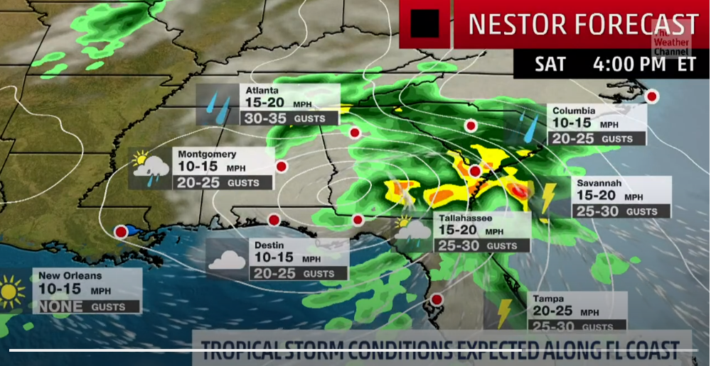
Tropical Storm Nestor to Bring Tornado Threat to Southeast on Saturday

Southeast surface winds will be pulling warm, moist air across Florida ahead of Nestor. This air mass will become increasingly unstable on Saturday.


There is some uncertainty over how far north the most unstable air will get. This will largely dictate the northward extent of the most intense thunderstorms.

There will be at least some potential for waterspouts or tornadoes on Sunday along the North Carolina coast and Outer Banks as whatever is left of Nestor races northeastward through the region.

Nestor may produce significant surge along Florida's Gulf Coast. However, the storm's rapid motion will reduce the threat of inland flooding from heavy rain.

Before temperatures plunge next week, drenching storms will soak the central US


The chilly air plunging in behind the storm will even allow for some snow to fall, but a repeat of the winterlike storm from earlier in the month is not anticipated. With that storm, heavy snow fell from the Northwest to the Colorado Rockies and northern Plains amid a dramatic temperature plunge.


"Heavy rain, strong winds and even an isolated tornado will all be possible," Adamson added.

Highs will come crashing down 10-20 degrees F with the passage of the storm.

Thursday, October 3, 2019

The Surpassing of October Temperature Records in Eastern U.S. Cities

On Tuesday alone, over 30 cities set new all-time high temperatures for the month of October.


"A roller coaster-like jet stream pattern across the country is to blame for the summer-like heat across a wide swath of the eastern United States," AccuWeather Meteorologist Brandon Buckingham said.

For a time on Wednesday afternoon, every weather station across eight different states were reporting temperatures higher than that of Death Valley National Park in California, one of the hottest places on Earth.


Wednesday, September 18, 2019

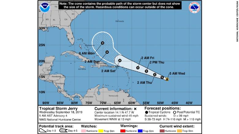
Hurricane Jerry in Atlantic- Possible Hurricane Later This Week

Jerry, the 10th named storm of this year's Atlantic hurricane season, was 855 miles east of the Leeward Islands late Wednesday morning. It had maximum sustained winds of 50 mph, the National Hurricane Center said.

From NHC: The cone contains the probably path of the storm center but does not show the size of the storm. Hazardous conditions can occur outside of the cone. The storm is expected to become a hurricane by Thursday night, It's too soon to tell if the islands will be affected, forecasters said.

https://www.cnn.com/2019/09/18/us/tropical-storm-jerry-wednesday-wxc/index.html