Showing posts with label Alexis McDaniel. Show all posts

Tuesday, December 8, 2015

Cold Front Expected Next Week

Weather whiplash means more than flip-flopping from drought to flood. It means that winter can vary from a bitter "Polar Vortex" to what we're experiencing now: a perfectly normal winter, for Tulsa, Oklahoma.
The metro area should have picked up a cool foot of snow by December 8. But only 5 inches of snow has fallen - much of that melting on contact early last week.
El Nino winters tend to be milder and drier. The last major El Nino (1997-98) 45 inches of snow fell during the winter at MSP. In 1982-83 a whopping74 inches fell. Every storm is different - every El Nino is different. It's dangerous making broad generalizations. But one thing is as certain as the wart on the end of my nose: the upcoming winter will be shorter than average
http://www.startribune.com/december-time-warp-hints-of-a-real-cold-front-late-next-week/360803441/

Severe UK Weather Warning

Britain is back on storm alert with 80mph gales and torrential downpours threatening a weekend of weather mayhem - with up to a month's worth of rain expected across 72 hours.
The Met Office has issued severe weather warnings for violent widespread gusts and potentially deadly flooding .
Forecasters warn up to four inches of rain will fall in parts over the next 72 hours as storms sweep in from the Atlantic.
Nowhere will escape a hammering this weekend as Britain battens down the hatches for the next round of winter chaos.
http://www.mirror.co.uk/news/uk-news/severe-uk-weather-warning-over-6947988
Floods: The River Ouse in York rises following several days of torrential rain

Citizens of Iceland Urged to Stay in Their Homes After 5 PM

The Civil Protection in Iceland has issued a statement warning people in South Iceland to stay put after 12 noon and people in Reykjavik and all other parts of Iceland to stay put after 5 pm this afternoon. The magnitude of the approaching storm is so great that such conditions occur only every 10 to 20 years, reports The Iceland Civil Protection. 
As we reported last night, the Iceland Met Office has issued a warning for hurricane force winds hitting Iceland today. All rescue teams and the Iceland Civil Protection are on high alert today.
It should also be noted that on the map below, the yellow to brown areas indicate winds of 90 mph and hurricane Sandy hit New Jersey at 80 mph. 
People should also be advised that there is a possibility of power cuts,  and also on today's checklist is making sure there are no loose objects in your garden or on your balcony. 
http://icelandmonitor.mbl.is/news/news/2015/12/07/reykjavik_don_t_leave_the_house_after_5_pm/
Rescue teams are on high alert today. The magnitude of ...

Flood Warnings in Effect for Oregon and Washington

Flood warnings are in effect for much of the region and many coastal rivers in northwest Oregon and southwest Washington with little relief in sight until Thursday, the National Weather Service said.
Rivers near or at flood stage include Johnson Creek in the Portland metro area, the Upper Tualatin River, the Siletz River, the Wilson and Trask rivers at Tillamook, the Grays River at Roseburg and the Nehalem River at Foss.
The warnings are in effect for Clackamas, Clatsop, Columbia, Lincoln, Marion, Multnomah, Polk, Tillamook, Washington and Yamhill counties in Oregon and Clark,  Cowlitz and Wahkiakum counties in Washington.
http://www.oregonlive.com/weather/index.ssf/2015/12/flood_warning_in_effect_for_co.html

Severe Fog in Beijing and India

World leaders are busily trying to avert future environmental catastrophe at the climate summit in Paris this week. But while they discuss what the atmosphere should look like decades from now, people in New Delhi and Beijing are struggling just to breathe the air of today.

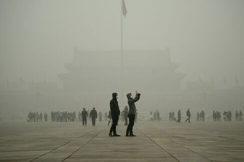
Both Delhi and Beijing are choked with heavy smog that exposes their combined 40 million residents to dangerously high concentrations of fine particles that can penetrate deep into human lungs. The toxic soup was so thick on Dec. 7 that authorities took the unprecedented step of issuing a “red alert” for Beijing, shutting down schools and construction sites to curb exposure to particulate levels over 10 times the World Health Organization’s recommended threshold. Delhi’s levels have been spiking just as high, leading authorities there to propose limiting the use of personal cars to alternate days.
http://qz.com/568560/china-and-indias-crazy-bad-smog-has-been-masking-global-warming/

Watching Greenland Melt From Paris

Olafur Eliasson, an Icelandic-Danish artist who lassoed and transported tons of ice from Greenland to Paris for a new climate change-inspired exhibit, bets you haven't.
"The truth is the ice is amazing. It's so touching to look at," he told me, standing in front of 12 hunks of Greenland that glittered blue-white in front of the Pantheon in Paris. The ice blocks -- totaling nearly 100 tons, he told me -- are arranged in the shape of a clock. You can see streaks of air and tiny bubbles in the ice. Put your ear to it, as I did at Eliasson's suggestion, and you hear a faint crackling sound. "It's a little concert," he said. "It's a little ice concert."
    The outdoor exhibit, called Paris Ice Watch, is meant to focus the world's attention on the increasingly ephemeral nature of these amazing ice hunks. Not too far away, in a Parisian suburb, officials from 195 countries are meeting at the U.N. COP21 climate change summit to try to figure out how to curb the most disastrous consequences of global warming.
    Paris Ice Watch is a reminder that the ice is melting as they talk.
    http://www.cnn.com/2015/12/08/opinions/sutter-ice-watch-cop21-two-degrees/

    Beijing Issues First Severe Smog Warning

    Beijing issued its most severe smog warning for Tuesday -- the first time the municipal government has issued a so-called red pollution alert -- after acrid-smelling haze returned to the Chinese capital.
    Local authorities upgraded the air pollution alert to red from orange, effective from 7 a.m. Dec. 8 to noon Dec. 10, according to a statement on Beijing Municipal Environmental Protection Bureau’s official Weibo Monday. Some industrial companies must stop or limit production, outdoor construction work will be banned and primary schools and kindergartens are advised to cancel classes, the statement said. Even healthy people should try to avoid outdoor activity and choose public transportation.
    http://www.bloomberg.com/news/articles/2015-12-07/smog-rolls-back-into-northern-china-after-brief-sunny-respite
    CHINA-ENVIRONMENT-POLLUTION-COP21

    A Year of Extreme Weather For India

    New Delhi: Unseasonal rains and crop damage in several states, followed by deficit rainfall and drought in nine states, topped off by a deluge in Chennai at the end of 2015.
    The year that is drawing to a close was dotted by extreme weather events, which are becoming more frequent. Several factors contribute to such events, posing new challenges for weather forecasting.
    Unseasonal rainfall in February and March for the second year in a row damaged crops in 14 states across the country; Rajasthan, Uttar Pradesh, Haryana, Madhya Pradesh, Maharashtra and Punjab were the worst hit. In August, floods caused by heavy rainfall claimed the lives of nearly 200 people and loss of property in Gujarat, Rajasthan, West Bengal, Odisha, Manipur, Meghalaya and Jharkhand.
    For the entire country, the June-September southwest monsoon rainfall was 14% less than normal, with 302 out of 640 districts experiencing at least a 20% shortfall.
    “There is an increase in extreme weather events and reduction in the number of rainy days. These are not good signs. Every year, we are breaking records of warm temperatures. You cannot see atmosphere in silos and this is a challenge in operational forecast and more research is required,” said L.S. Rathore, director general, India Meteorological Department (IMD). Rathore added that as variability in weather increases, the uncertainty of weather also increases, posing a challenge for weather forecasting.
    http://www.livemint.com/Politics/4SbC4kGC9cYt2oxtrYS6eP/A-year-of-extreme-weather-conditions-for-India.html
    Unseasonal rainfall in February and March for the second year in a row damaged crops in 14 states across the country; Rajasthan, Uttar Pradesh, Haryana, Madhya Pradesh, Maharashtra and Punjab were the worst hit. Photo: Reuters

    Chain of Storms Puts Portland Underwater

    A chain of Pacific storms that began last week has caused heavy, sustained rainfall in western Oregon, creating major headaches in and around Portland.
    The storms are forecast to last through the week, which means the threats of flooding and landslides will worsen. Here are the latest impacts: 

    Oregon

    According to Portland’s Bureau of Environmental Services, heavy, sustained rainfalls have overflowed the city’s combined sewer system into the Willamette River Monday. Residents are urged to avoid contact with the river from the Sellwood Bridge to the Columbia River due to increased bacteria in the water. 
    KATU reported that at least 100 families were evacutated from an apartment complex in southeast Portland due to rising waters.
    In Eagle Creek and  Estacade firefighters went door to door Monday night asking residents to be prepared to evacuate if the Clackamas River continues to rise.
    "It's scary because you can't see it, from the house, you don't know where it is," Danee Rardin told KATU. "I drove home from work on Highway 30 and that was a trek, that was scary, actually. I don't know, we'll see. I won't sleep tonight."
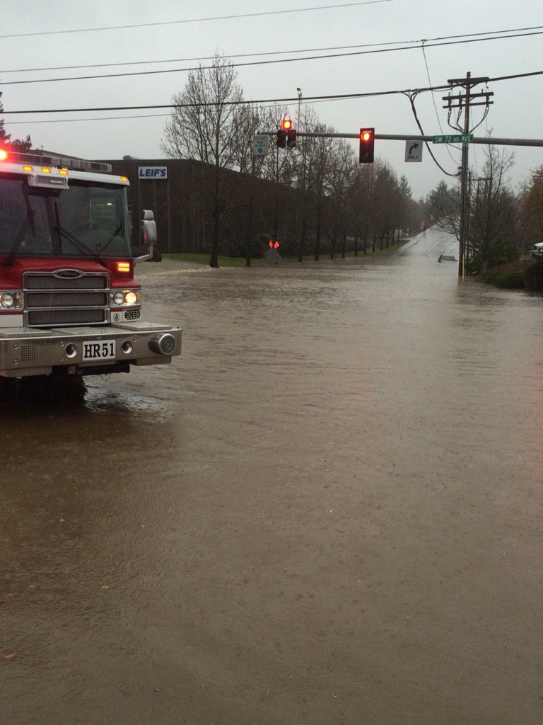
    The Tigard Police Department tweeted that high waters were reported in multiple areas throughout the city. The flooding shut down roads, including Dartmouth Street and the intersection of Bonita Road and 72nd Avenue.
    http://www.weather.com/storms/severe/news/pacific-northwest-storm-impacts
    Embedded image permalink

    Storm Desmond Forces Thousands Out of Homes

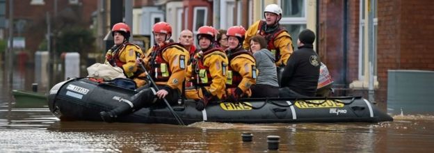
    Thousands of people have been flooded out of their homes or left without power after Storm Desmond wreaked havoc in parts of the UK.
    In Cumbria and Lancashire more than 43,000 homes are suffering from power cuts, while an estimated 5,200 homes have been affected by flooding.
    The weather has claimed two lives - in Cumbria and the Republic of Ireland.
    David Cameron said the flood defences in Cumbria "were not enough" and some people might not be home for Christmas.
    Storm Desmond lashed parts of Northern Ireland, north Wales, southern Scotland and especially north-west England over the weekend, and more heavy rain is expected this week.
    Record-breaking amounts of rain fell in Cumbria, the worst-hit county - prompting the county to declare a major incident.

    http://www.bbc.com/news/uk-35023558
    Rescue workers in Carlisle

    Friday, December 4, 2015

    Flooding in India forces many to Evacuate

    Torrential rain has triggered massive flooding for the second time in about two weeks in the southern India state of Tamil Nadu.
    The Associated Press reports that thousands have been forced to leave their homes, schools and offices due to the floodwaters. In addition, a regional airport in the area was closed for a second day Thursday and the main train station was also shut down because of heavy flooding.
    At least 269 people had been killed in the state since heavy rains started in the beginning of November, said India's Home Minister Rajnath Singh, although no deaths have been reported in the latest deluge.
    http://www.weather.com/news/news/chennai-india-floods-december-2015
    Enhanced Satellite: Southern India

    Warm Weather to Dominate the U.S.

    It has not felt much like December so far across parts of the United States, but by next week practically nobody will feel like December in the Lower 48 as above-average temperatures take over virtually the entire country.
    Although parts of the Northwest and Midwest saw some wintry weather to start the month, it may be quite some time before the next widespread, significant winter storm threatens the Lower 48.

    Cold Air Stays Bottled Up North

    As we start meteorological winter, which runs from Dec. 1 through Feb. 29, true arctic air remains locked up in extreme northern Canada, well to the north of the U.S. border and even well north of all the major Canadian cities.
    While December is early in the winter season, it is quite common for chunks of bitterly cold air to reach the U.S. during the first half of the month.

    http://www.weather.com/forecast/national/news/warm-united-states-december-2015

    Severe Weather Causes Blackouts in Northern Ireland

    The electricity supplier said there is a possibility of damage to the electricity network, especially in exposed and coastal locations, due to the severe weather expected over the coming days.
    The warning comes after the Met Office issued a yellow "Be prepared" warning for severe wind and rain expected across Northern Ireland over the weekend.
    In a statement the electricity supplier said they had initiated an escalation plan and put emergency crews, engineers and call handlers on stand-by.
    NIE Networks said that if customers do lose power they should contact the NIE Networks Customer Helpline on 03457 643 643 or report the fault online atnienetworks.co.uk.
    Regular updates on the power situation can also be found on the NIE Networks Twitter account @NIElectricity
    NIE Networks spokesman Ruadhrai O’Kane urged everyone to think about their personal safety  should power be disrupted.
    advertisement
     “If there is any damage to our network from severe weather, our emergency crews will be in position to get customers back on supply as quickly as possible, consistent with safety, and we will keep customers regularly updated and informed," he said.

    http://www.belfasttelegraph.co.uk/news/northern-ireland/northern-ireland-electricity-warns-of-possible-blackouts-as-severe-weather-hits-province-34260360.html
    Ireland can expect up to 200mm of rainfall. Pic: The Weather Company.

    Winter Storm Delphi

    The heaviest snow totals ranged from 8-12 inches over parts of South Dakota, northern Nebraska, southwest Minnesota and northwest Iowa.
    The top snow totals from the storm were 12 inches near Valentine, Nebraska, and near Mosher, South Dakota. Minnesota saw up to 9.5 inches in Madison, while Iowa saw up to 9 inches in Hull.
    http://www.weather.com/storms/winter/news/winter-storm-delphi-midwest-plains-corn-belt-november-december-2015

    El Nino may affect Christmas

    Putting all the previous strong El Niño Decembers together, you'll note the widespread warmth over most of the eastern two-thirds of the nation, from the High Plains of Montana to New England. Not a good sign for snow either falling or remaining on the ground.
    However, this is an average of those five Decembers. Not all of those were warm. December 1972 (animation of the Dec. 1-25 temperature departures in each of those seasons) was quite cold over the Plains, Upper Midwest and northern Rockies.
    However, note the average precipitation over those five Decembers was wetter than average not just over where you would expect it in a strong El Niño – namely, the nation's southern tier – but also in a ribbon extending northeast into the Mississippi Valley and western Great Lakes.
    So, at least historically speaking, there's a better chance of December precipitation that, if the air mass happens to be cold enough at that time, could fall as snow.
    http://www.weather.com/storms/winter/news/el-nino-white-christmas-impact

    Tornadoes in the Plains

    Between late Monday and early Tuesday morning, a preliminary count of 28 tornadoes struck Kansas, Texas, Oklahoma and Nebraska, according to Dr. Greg Forbes of The Weather Channel. One of the confirmed tornadoes occurred near Pampa, Texas Monday evening, caused major damage, downing power lines and causing gas leaks and around 47,000 Texas and Oklahoma residents without power. The strong winds and tornadoes that raked throughout the plains also caused thousands to lose power in Southern California.

    http://www.weather.com/news/weather/news/severe-weather-in-a-week

    Winter Storm Ajax

    Winter Storm Ajax delivered a crippling combination of snow and wind to parts of the High Plains from late Nov. 16 into early Nov. 18. The storm also dumped snow from California's Sierra Nevada into the Rockies Nov. 15-16. The storm dumped more than a foot of snow in some locations with wind gusts topping 60 mph.

    http://www.weather.com/storms/winter/news/winter-storm-ajax-snow-plains-rockies-denver-november-2015

    Saturday, November 28, 2015

    Chilly weather warnings for California

    Parts of the Bay Area and Central Valley will see overnight temperatures Saturday drop below 32 degrees, which could result in damage to crops, the weather service said.
    Freeze warnings were issued for parts of the San Joaquin Valley and interior valleys north of San Francisco Bay. Freeze watches are in effect from the northern San Joaquin Valley through the Sacramento Valley, forecasters said.
    http://www.latimes.com/local/weather/la-me-ln-california-weather-20151127-story.html
    California snow

    Wet, chilly weather expected for Texas

    weather ra
    A fairly gentle cold front dropped Central Texas temperatures almost 20 degrees in an hour Friday morning and promised more rain the rest of the weekend, but no freezing temperatures, watches or warnings are anticipated for the Waco area, according to the National Weather Service.
    But NWS meteorologist Jamie Gudmestad said Bosque, Hill and Navarro counties, all to the north of Waco, will be under flash flood watches until Sunday morning.

    Gudmestad said Itasca, in Hill County, had a two-day rainfall total of 2.82 inches through Friday. McGregor had 1.65 inches in the same period, and Waco Regional Airport posted a two-day total of only 1.29 inches. She said another two inches of rain are expected in Waco by the end of Saturday.
    http://www.wacotrib.com/news/weather/wet-chilly-weather-expected-for-central-texas-as-flooding-ice/article_2c99789e-442a-54fc-acd1-1f5c5987b83f.html

    Freeze warning in effect for San Diego

    SAN DIEGO (CNS) - The cold low pressure system responsible for the snow Saturday will lead to cooler weather for the next couple days, according to the National Weather Service.
    Forecasters said already chilly temperatures were expected to drop to sub-freezing tonight in some areas.
    A freeze warning for the valleys will remain in effect Saturday night into Sunday morning. Locales included under the advisory include Alpine, Jamul, Rainbow, Ramona and Valley Center.
    High temperatures of 38 to 48 degrees in the mountains are expected to fall to between 18 and 28 degrees tonight. In the valleys and deserts, patchy frost is expected to form tonight in colder, wind-sheltered locations amid low temperatures of 27 to 35 degrees and 29 to 37 degrees, respectively.
    Forecasters warned that such low temperatures can damage unprotected plants and crops and could harm outdoor pets.
    On Friday, wintry weather, rain and mountain snow prompted road closures and snow chain requirements in parts of San Diego County.
    Snow showers developed over the mountains late Thursday night and continued periodically through Friday afternoon. A winter weather advisory for mountain locales including Julian, Pine Valley, Palomar Mountain and Mount Laguna remained in effect until 4 p.m.
    The snow level on Palomar Mountain dropped overnight to about 4,000 feet above sea level. About three inches of powder was on the ground at about 9 a.m.
    Around four inches of snow had also accumulated on Sunrise Highway, southwest of Mount Laguna, according to the California Highway Patrol. Julian got a light dusting as well, according to the weather service.
    Motorists were required to use tire chains on snow covered Palomar Mountain roadways, and on Sunrise Highway between Interstate 8 and state Route 79, according to the county Department of Public Works.
    http://www.cbs8.com/story/9532416/freeze-watch-in-effect-for-parts-of-san-diego-county