Showing posts with label Anne Pertner. Show all posts

Thursday, May 2, 2013

Warming Up - Jet Stream on the move!

http://www.itv.com/news/calendar/2013-04-10/warming-up-jet-stream-on-the-move/

The Jet Stream is a fast moving ribbon of air in our upper atmosphere that brings weather systems from west to east towards the UK. It is affected by both cold polar air from the north and warm tropical air from the south. The battle between these two air masses makes the jet stream 'buckle' or 'kink', allowing wave-like patterns to form. This affects the positioning of the Jet Stream in relation to the UK - and in turns affects the nature of the weather over the UK.

So far this Spring the Jet Stream has been much further south than we would expect. It has kept Low Pressure systems at bay and instead has allowed High Pressure to influence our weather - bringing mainly dry but cold conditions for the past few months.
This means the Jet Stream has been feeding wetter and warmer weather into parts of Europe. Spain, for example, has had its wettest March on record. Rain was persistant here for most of the month, bringing an average of 157mm compared to normal values of 46mm. That works out at 340% of the expected March rainfall - the wettest in 65 years, since records began. This rain on a typical start to Spring would have been reserved for Scotland.

Blame the jet stream for our weather again this year

http://www.leaderpost.com/technology/Blame+stream+weather+again+this+year/8237087/story.html


REGINA — What a difference a year makes!
One year ago, we in Saskatchewan were emerging from one the mildest winters in memory. And for that, we were thanking the jet stream — the powerful, high-altitude air currents that meander around the globe from west to east.
Last year, they stayed well to the north of us and give just about all of Canada from Alberta eastward an unusually mild winter.
This year, things are different. And, once again, we have to acknowledge our cold, er, old friend, the jet stream.
“Our average high temperature in Regina over the first 11 days of the month has been a paltry -2C. That’s about 10C colder than the normal, and a whopping 12C colder than the same period last year,” The Weather Network’s Chief Meteorologist, Chris Scott, wrote in an email Friday.
“A stubborn and persistent dip in the jet stream across central North America is responsible for the cold weather. This weather pattern looks to ‘hold tough’ through much of next week, with some signs of breaking down for the last week of April.”
Yes, breaking down. The Weather Network’s 14-day outlook for the next two weeks, posted Friday, shows below-normal highs and low temperatures in Regina and area until about April 24.


Read more: http://www.leaderpost.com/technology/Blame+stream+weather+again+this+year/8237087/story.html#ixzz2SCiOuLQm

Climate change will lead to bumpier flights, say scientists

http://www.guardian.co.uk/environment/2013/apr/08/climate-change-air-turbulence


Climate change will lead to bumpier flights caused by increased mid-air turbulence, according to an analysis by scientists of the impact of global warming on weather systems over the next four decades.
The increasing air turbulence results from the impact of climate change on the jet streams, the fast, mile-wide winds that whistle round the planet at the same altitude as airliners. The shifting of the jet stream over Europe has also been blamed for the UK's wash-out summer in 2012 andfrozen spring this year.
The rough ride ahead joins other unexpected impacts of climate change, which include dodgier wi-fi and mobile phone signals and even slower marathon race times for athletes.
Paul Williams, at the University of Reading who led the new research, said: "Air turbulence does more than just interrupt the service of in-flight drinks. It injures hundreds of passengers and aircrew every year. It also causes delays and damages planes, with the total cost to society being about £100m each year."

Why our turbulent weather is getting even harder to predict

http://www.guardian.co.uk/uk/2013/apr/07/science-behind-britain-coldest-easter


Britain's weather excelled itself last week. It produced an Easter Sunday that was the coldest on record in the UK. Temperatures stuck below zero in many regions; freezing conditions continued to disrupt transport; and experts warned of increasing threats to animals and birds already struggling to survive loss of habitat and climate change. The start of British Summer Time last Sunday night was marked in Braemar by temperatures that fell to -11C. For good measure, an unappetising April looks likely to follow this misery.
The persistence of the spring's grim weather is particularly striking for it comes after a series of other extreme meteorological events in recent years. Last winter, a severe drought triggered stern warnings by the Environment Agency that water rationing and hosepipe bans would soon have to be introduced – until several months of torrential rain produced widespread flooding.


Ridge in jet stream brings area warmth, but threat of showers

http://www.sungazette.com/page/content.detail/id/591229/Ridge-in-jet-stream-brings-area-warmth--but-threat-of-showers.html?nav=5011


Temperatures in northcentral Pennsylvania climbed well above normal levels Sunday, welcoming in a reprieve from weeks of colder weather, according to the National Weather Service in State College.
The high temperature recorded at the Williamsport Regional Airport Sunday was 66. That's well above the normal mid-50 degrees for this time of year, said weather service meteorologist Barry Lambert.
He said a ridge in the jet stream is ushering warmer conditions into the northeast.

Saturn North Pole Plays Host To Massive Hurricane Surrounded By Hexagonal Jetstream

http://www.ibtimes.com/saturn-north-pole-plays-host-massive-hurricane-surrounded-hexagonal-jetstream-photos-1223523


On Saturn’s north pole, scientists have just discovered a storm bigger than any tempest ever seen on Earth.

Global Warming: Rare May Snowstorm Pounds Wisconsin, Minnesota

http://www.theyeshivaworld.com/news/General+News/166731/Global-Warming%3A-Rare-May-Snowstorm-Pounds-Wisconsin,-Minnesota.html


An unseasonable winter storm system dropped more than a foot (30 cm) of snow across the central Plains and the upper Midwest on Thursday, closing roads and causing power outages in Minnesota and Wisconsin.
The system has resulted in about 18 inches (46 cm) of snow falling in parts of northwest Wisconsin and more than 15 inches (38 cm) in southern Minnesota, according to the National Weather Service reported.
“The northernmost areas have seen snow in May before, but not of this magnitude,” said Jim Keeney, a meteorologist for the National Weather Service.

Milken Conference: Al Gore Rocks Crowd With Global Warming Speech

http://www.hollywoodreporter.com/news/milken-conference-al-gore-rocks-449247

Al Gore, one of Hollywood's favorite sons because of his commitment to the environment, rocked a large crowd in Beverly Hills on Tuesday with an impassioned plea to solve the "climate change crisis," part of which is getting media right.
Gore lamented that a modern-day Thomas Paine would not be able to get his "Common Sense" message to the masses today because he couldn't afford TV airtime, and he criticized the "rise of television at the expense of the printing press."

Record low in Arctic sea ice caused by global warming, says UN

http://www.telegraph.co.uk/earth/environment/climatechange/10033034/Record-low-in-Arctic-sea-ice-caused-by-global-warming-says-UN.html

Global warming not only increased temperatures last year, according to the UN annual summary of climate change, but caused a record low in Arctic sea ice, deadly storms and economic uncertainty.


The World Meteorological Organisation, that tracks the weather on behalf of the 193 countries of the United Nations, confirmed 2012 was the 9th warmest year on record.
The annual summary of climate change also warned Arctic sea ice reached its lowest ever level, rainfall increased causing floods around the world and a number of countries experienced drought.
Extreme weather events, like Superstorm Sandy in the US and Typhoon Bopha in the Philippines, were linked to climate change.
Michel Jarraud, Secretary-General of the WMO, said natural variability - like the La Nina/ El Nino pattern in the Pacific - means global warming will not necessarily make each year successively warmer than the last.

Most Americans Blame Global Warming for Extreme Weather

http://www.livescience.com/29222-climate-change-extreme-weather-report.html


More than half of Americans think global warming is affecting weather in the United States, according to a new nationally representative survey that measures the pulse of American sentiment on climate change.
The newly released study shows that about two out of three Americans say weather in the country has worsened over the past several years, with only one in 10 saying the weather has been improving.

ALLAN SAVORY TO REVERSE DESERTIFICATION, SOLVE GLOBAL WARMING, FEED WORLD’S POOR

http://singularityhub.com/2013/05/02/allan-savory-to-reverse-desertification-solve-global-warming-feed-worlds-poor/


As a young scientist in Africa, Allan Savory helped set aside national parks. His organization removed indigenous “hunting, drum-beating people” to protect animals. Newly burgeoning herds of elephants were then identified as causing desertification by overgrazing. Savory theorized as much in a paper and sent it to his peers for review. Other scientists corroborated the report, and the government killed 400,000 elephants.
Instead of improving, desertification worsened.
Savory opens his recent TED talk with this story, assuming responsibility for an awful mistake. But, he says, the experience taught him a lesson, “One good thing did come out of it. It made me absolutely determined to devote my life to finding solutions.” I had to rewind the video the first time I heard that.
According to his account, this was a man already devoted to finding solutions, and those solutions, implemented on a grand scale, failed just as grandly. That experience might imbue some with a severe and undying sense of humility in the face of nature’s grandeur and complexity. Not so, Allan Savory.
Savory says his favored solution—holistic management and planned grazing—is the right solution and should be implemented on an even grander, global scale. “I can think of almost nothing that offers more hope for our planet, for your children, and their children, and all of humanity.” Queue the standing ovation.

SH 88_#2 BIG

Greenhouse Effect: CO2 Concentrations Set to Hit Record High of 400 PPM

http://science.time.com/2013/05/02/greenhouse-effect-co2-concentrations-set-to-hit-record-high/


Climate change is, first and foremost, a consequence of the addition of carbon dioxide into the atmosphere. We emit carbon dioxide, through burning fossil fuels or forests, and some of that carbon stays in the atmosphere, intensifying the heat-trapping greenhouse effect and warming the climate. What kind of global warming we’ll see in the future will largely be due to how much carbon dioxide—and to a lesser extent, other greenhouse gases like methane—we add to the atmosphere. And to fully understand the future, we need to understand the present and the past, and track the concentration of CO2 in the Earth’s atmosphere.
The fact that we can and have been tracking that very important number is due largely to the efforts of the geochemist Charles David Keeling. As a postdoctoral fellow at the California Institute of Technology in the 1950s, Keeling developed the first instrument that could accurately measure the CO2 levels in the entire atmosphere through sampling. When he got to the Scripps Institution of Oceanography a few years later, Keeling began taking regularly CO2 measurements at the Mauna Loa Observatory in Hawaii. Keeling discovered that atmospheric CO2 underwent a seasonal cycle, as plants bloomed and decayed in the Northern Hemisphere, and more importantly, that CO2 was rising fast. In 1958, CO2 levels recorded at Mauna Loa were about 316 parts per million (ppm). By 2005, when Keeling died—and his son, Ralph Keeling, took up the project—CO2 levels were just under 380 ppm. Plotted on a graph, the readings over time curve upwards sharply as humans added more and more CO2 to the atmosphere—which is why the readings came to be known as the Keeling Curve.


Read more: http://science.time.com/2013/05/02/greenhouse-effect-co2-concentrations-set-to-hit-record-high/#ixzz2SCf4u4pO

A Tornado Drought

http://wearecentralpa.com/fulltext-news?nxd_id=457782


Drought is a bad thing -- unless you're talking about a tornado drought. That was the situation in 2012, when the number of twisters touching down in the continental U.S. was significantly fewer than the 30-year average (red). So far, 2013 (green) is looking pretty sparse as well, with the caveat that states in northern sections of Tornado Alley don't hit their storm stride until later in the spring and summer. Still, other than a few specific areas, the nationwide January through April tornado count is way down, 54 percent to be exact.
Pinpointing the reason for tornado droughts (and deluges) isn't always easy. Last year's drought -- the actual drought that devastated much of the Great Plains -- robbed the atmosphere of the water vapor that fuels severe thunderstorms. Since tornadoes come from thunderstorms, this key thunderstorm ingredient was missing.
This year, while the drought is still going on, it's much less severe -- yet we may be seeing another tornado drought in the making. This time, it may be the relatively cool spring air much of the nation has been experiencing. Heat is another key ingredient of thunderstorms.
As for 2014 and beyond, it's natural to wonder if shifts in the climate will make tornado activity more or less severe. The answer is not clear. Since tornadoes play out in the atmosphere, it's likely that a changing climate will also change tornado activity. But tornadoes are complicated beasts, affected not only by moisture and temperature but also by wind shear and other factors.

Worst drought affects fire season preps


PLACITAS, N.M. (KRQE) - The Piedra Fire in the Sandia Mountains comes at a dangerous time just as a federal agency reports New Mexico's drought is now the worst in the nation.
The driest stretch includes the Rio Grande Valley.
That is one of the many reasons wildland firefighters Thursday were throwing everything they can into this fight.
Fire bosses say crews are prepared to camp out and work into the night as they try to corral the fire in a steep, forested canyon on the west face of the Sandias.
Crews are using tens of thousands of gallons of water to fight the Piedra Fire and have been hard at work since before the sun came up.
“They are working with hand tools and chainsaws, and you can hear behind us they will be working with a lot of air support,” says Arlene Perea with the Cibola National Forest.
To make matters worse, New Mexico is seeing worst drought conditions in the country.  Experts say the drought is expanding and becoming more long term, which could mean a more dangerous fire season.
“There is never any option other than full fire suppression on this fire or any other that starts now,” Perea adds.
That means a team effort involving multiple agencies with planes and helicopters working to help dozens of people fighting the fire on the ground.
Portable pools that hold about 5,000 gallons of water have been deployed with the Sandoval County Fire Department shuttling back and forth all day to keep them full.
“I knew it was going to be real tough on us on where we're going to get the water from," Deputy Fire Chief Jess Lewis said.  "We've gone to ditches that do supply irrigation to farmers, and we're being sensitive to that and not using anything unnecessary."
A state climatologist said things aren't likely to change with below-normal precipitation and above-normal temperatures expected in early summer.
“All these different agencies work hard on preparing because we know drought will play a big role in this fire season,” Perea says.
Firefighters said it's a three-hour hike to actually get to the fire, but the good news is because it is in such a remote area, it is not endangering any nearby residents or buildings. 

Floods eased drought in Midwest; West now a concern

http://www.usatoday.com/story/weather/2013/05/02/floods-drought-midwest/2129585/


The record flooding has ended the disastrous drought in some, but not all, parts of the Midwest, federal drought experts reported Thursday.
Meanwhile, the Far West is still suffering from a lack of wintertime rain and snow, adding to drought and wildfire worries there.
Thursday's U.S. Drought Monitor, a weekly federal website that tracks drought across the country, noted, surprisingly, that the Upper Midwest remains in a low-level drought, as the region continues to deal with long-term precipitation deficits, despite the seasonal spring flooding.
It's been very cold in Minnesota and the Dakotas, which "still have a layer of frozen ground 1 or 2 feet down," says U.S. Department of Agriculture meteorologist Eric Luebehusen, the author of this week's monitor. This means that much of the moisture from the rain and snow did not soak in, he says, which exacerbated the flooding.
In fact, the monitor reports that more than 90% of the state of Minnesota remains either abnormally dry or in a drought. "We're taking it slow with drought recovery in that area," he says.
But other Midwest states such as Indiana, Illinois, Kentucky and Tennessee -- all of which were in a drought last summer -- are now entirely drought-free.
Nationally, 46.9% of the contiguous U.S. is in a drought. "Drought coverage is now down 14.19 percentage points since the beginning of 2013 and down 18.55 points from the record high of 65.45% on Sept. 25, 2012," said Brad Rippey, a meteorologist with the U.S. Department of Agriculture.
Drought in the Southeast is now almost entirely gone, Rippey noted. North Carolina is now completely free of drought for the first time since November.
"However, there is an increasingly sharp gradient between drought and non-drought areas; currently that line stretches roughly from the Texas-Louisiana border to Lake Superior, with drought to the west of that demarcation zone," he says.
Worries are now shifting to the West: The water year in the Southwest was "abysmal," Luebehusen says.

tornado-report-forest-city

http://www.wlos.com/shared/news/features/top-stories/stories/wlos_tornado-report-forest-city-11432.shtml

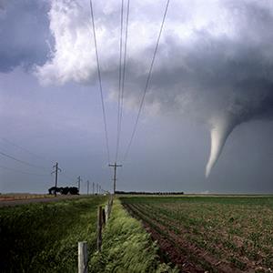
Reports of funnel clouds around 1 p.m. this afternoon caused some Rutherford County residents to seek cover, and others to call 911. As the county's Emergency Communications Center fielded calls, some officers scanned images of the clouds popping up on Facebook and Director Tammy Aldridge contacted the National Weather Service with photos. NWS identified the funnels - one reported around Ellenboro, a second south of Forest City - as a small, weak type of tornado called a land spout. A landspout is a type of "tornado" not associated with a thunderstorm, they form in a different way then your typical supercell thunderstorm tornadoes often characterized by strong, damaging winds. Local officials say the funnels Tuesday did not touch down or cause damage. While a typical tornado develops from rotation within the supercell thunderstorm eventually coming down from the cloud making contact with the ground, landspouts develop when a circulation at the surface is picked up by the updraft of a thunderstorm and eventually that circulation is "ingested" into the cloud.  An easier way to think of it is a "tornado" forms in the cloud and eventually works its way down to the surface while a landspout begins at the surface and works its way up into the cloud.  Since a tornado is defined as a rotating column of air in contact with the earths surface and the cloud above, technically a landspout is a tornado by definition.

Read More at: http://www.wlos.com/shared/news/features/top-stories/stories/wlos_tornado-report-forest-city-11432.shtml

Snow expected, may be heavy in Northwestern Wisconsin

http://www.duluthnewstribune.com/event/article/id/265930/


Record April snow, an unusually warm string of days, thunderstorms and now the possibility of snow in May are all contributing to Northland rivers spilling over their banks, some of them flooding roads.
No major flooding was occurring or expected in the Northland, but the National Weather Service has posted advisories for small streams across the region, and several roads have been closed. Fairly heavy rain and snowfall expected tonight could add to the flooding problem later in the week, especially in Northwestern Wisconsin.
The National Weather Service in Duluth says 6 to 12 inches or more of snow is possible along a line from north of the Twin Cities to Ashland and Ironwood. A winter storm warning is posted for Burnett, Douglas, Sawyer, Bayfield, Ashland and Iron counties. A winter weather advisory, for an expected 3 to 6 inches, is posted for Carlton, southern St. Louis, Lake, Cook and Pine Counties in Minnesota — including Duluth.
The precipitation will begin as rain early today and then transition to a wintry mixture of rain and snow throughout the day and then all snow by sunset.
The additional precipitation, up to an inch of rainfall equivalent in Northwestern Wisconsin, will only add to the hydrological overload, said Dean Melde, meteorologist for the Weather Service in Duluth.

Hail, thunderstorms batter Canterbury

http://www.stuff.co.nz/the-press/news/your-weather/8613139/Hail-thunderstorms-batter-Canterbury


Canterbury has been battered by hail, thunderstorms and heavy rain, sparking flooding in some parts of Christchurch.
An 80-year-old woman suffered "borderline hypothermia" when she was caught in the rainstorm on Mt Herbert.
A Westpac rescue helicopter spokesman said the woman was part of a walking group who were "caught off guard" by the weather in Purau.
The group took shelter in a nearby hut until rescuers arrived.
The spokesman said she was "shivering and extremely cold" when they arrived.
She was flown to Christchurch Hospital  for observation.
Rain also came pouring through part of the ceiling in the Wicked Campers office on Ferry Rd, with water still dripping from ceiling this afternoon.
A Wicked Campers employee, who did not want to be named, said it was "like a waterfall" pouring through the ceiling.
She began placing buckets down to try and contain the deluge.
"But that didn't really help," she said.
She rushed to move items being hit by the downpour, but the floor was flooded, soaking through the carpet.
"It was like a wee river."
She removed electrical items from the affected room, in case the rain began coming through other parts of the ceiling.
Despite the problems the weather had caused to the office, it had not impacted business.
"It was business as usual. Although people may have had to have waited a few more minutes until we found things we'd moved."
She was not concerned if more heavy rain came tonight.
"It can't do any more damage than what it's already done."


rain6

No damage, but lots of rainfall as storm pushes east through Tennessee


NASHVILLE, Tenn. — Storms moving across West Tennessee were not as severe as earlier expected, but they were a lot wetter.
National Weather Service meteorologist Jim Branda in the Memphis forecast office said early today there had been no reports of injuries or serious damage from wind that had gusted to 45 mph.
“No, none at all,” Branda said.
The Tennessee Emergency Management Agency headquarters in Nashville also reported no reports of storm damage.
However, storms were moving slowly northeastward, dropping heavy amounts of rain. By 3 a.m. CDT, there were reports of up to 2 1/2 inches of rainfall in some places in West Tennessee. The entire region, from the Mississippi River to the Tennessee River, was under a flash flood watch.
“A slow-moving cold front and an upper level low in the Central Plains has storms following each other across the same areas,” Branda said.
NWS expected an additional 2 to 3 inches of rain before the storms rolled across the Tennessee River into Middle Tennessee later in the morning. Even then, lingering showers were expected to add to the rainfall total. The flash flood watch was in effect until 7 p.m. for counties near the Tennessee River.
As the same weather system lumbers slowly eastward, Middle Tennessee was expected to begin receiving thunderstorms after sunup.
A 100 percent chance of rain is forecast for today and showers into the nighttime hours are expected.
In Chattanooga, forecasters expect the storms to begin around 1 p.m. today and the heaviest rain should fall overnight into Friday.
Thunderstorm chances in Knoxville will pick up at midafternoon, with the heavier rain expected at night.
The storms should roll into the Tri-Cities area during the afternoon commute and the heaviest activity is expected well after dark.
Forecasters expect the heaviest rainfall to be out of Tennessee by dawn Friday.
Temperature will fall behind the cold front. In Bristol, forecasters expect lows to be in the upper 30s. Memphis will bottom out in the mid-40s.


http://www.timesfreepress.com/news/2013/apr/11/no-damage-lots-rainfall-storm-push-east-through-te/

It's tornado time, and insurance rates are spinning up

http://money.msn.com/now/post.aspx?post=25acdfc9-bca1-4c2d-9173-d38f3ef9e99d


People in Oklahoma are watching the skies with particular care these days as their region enters what is historically one of its worst seasons for severe weather. On May 10, 2010, a total of 55 tornadoes swept across the state -- including two massive, EF4 twisters that hit metro Oklahoma City, killing three people and injuring more than 80 others.

"Anything can happen in any given year," National Weather Service meteorologist Rick Smith told KFOR-TVin Oklahoma City, "but certainly these first 10 to 15 days in May are really prime time for tornadoes in the state."

Tornadoes have occurred in nearly every U.S. state and at all times of the year, but every spring and into summer, the Lower 48 enters a period of increasing frequency and strength for these lethal -- and economically devastating -- weather systems.

The Insurance Information Institute says two of the most costly natural disasters in recent years in terms of property damage have been tornadoes. The April 2011 tornado in Tuscaloosa and Birmingham, Ala. ($7.3 billion in insured property losses) left 65 people dead. And another series of severe weather the following month, including the tornado that tore through Joplin, Mo., that killed 161 people, led to a $2.1 billion in insurance claims. All told, nearly $7 billion in claims were paid due to severe weather in the U.S. just for the period of May 20 to May 27, 2011.

According to Munich Re (MURFG), the world's largest insurance company, $5 billion in losses resulted from tornadoes during a three-day outbreak in March 2012, of which only 50% was insured. And while that damage toll is less than in previous years, it was just one-tenth of the overall losses inflicted by Superstorm Sandy last November.

In fact, as instances of severe weather events grow, concerns are mounting that the insurance industry might be shifting more of the risk and costs for these catastrophes back onto consumers and taxpayers.


Tornado in Nebraska (© Gene Rhoden/Weatherpix/Getty Images)