Showing posts with label Aurora Lucas. Show all posts

Wednesday, April 24, 2013

Midwest Floods: Forecasted Rain, Snow Could Lead To More Flooding


CLARKSVILLE, Mo. — Her Missouri hamlet soon to celebrate its 200th birthday, Mayor Jo Anne Smiley embraces Clarksville's perilous place along the Mississippi River, never mind that that the waters again threaten to wipe it and its potpourri of specialty shops off the map.

In places like Clarksville and the Illinois town of Grafton just across the river, it's always been the clear views of the Mississippi drawing the tourists, unobstructed by a permanent levee. But that's left both communities north of St. Louis vulnerable.

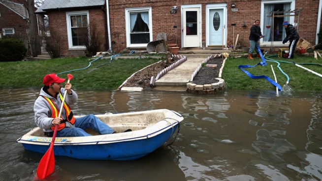
By Monday, the rain-swollen river strained a hastily erected makeshift floodwall in Clarksville, creating two trouble spots that volunteers were scrambling to patch – as well as build a second sandbag wall to catch any water weaseling through.

But though the Mighty Mississippi is starting to recede, another batch of rain threatens to push it back up. A swath from Oklahoma through Michigan is forecast to get an inch of rain – in some cases slightly more – through Tuesday. The National Weather Service said some river levels again could rise, blunting their slow retreat.

Mark Fuchs, a National Weather Service hydrologist, said the latest dousing could be especially troubling for communities along the Illinois River, which he said is headed for record crests.

"Along the Illinois, any increase is going to be cause for alarm, adding to their uncertainty and, in some cases, misery," he said late Monday afternoon.

Last week's downpours brought on sudden flooding throughout the Midwest, and high water is blamed for at least three deaths. Authorities in LaSalle, Ill., spent Monday searching for a woman whose van was spotted days earlier near a bridge over the flooded Illinois, and a 12-year-old boy was in critical condition after being pulled from the Big River near Leadwood, Mo., about 65 miles south of St. Louis, after floodwaters swept him away as he tried to walk across a bridge.


Elsewhere, smaller rivers were continuing to cause big problems. In Grand Rapids, Mich., the Grand River crested Sunday at a record 21.85 feet, driving hundreds of people from their homes and flooding parts of downtown.

The flooding also created some odd scenes. In Fox Lake, Ill., carp from the swollen Fox River were seen swimming on driveways.

And near St. Louis, all 114 barges that broke loose over the weekend were accounted for. U.S. Coast Guard Lt. Colin Fogarty said 11 sank and the river will remain closed over a 15-mile stretch out of safety concerns. It wasn't clear when the river would be allowed to reopen.

http://www.huffingtonpost.com/2013/04/22/midwest-floods-april-2013_n_3130348.html?utm_hp_ref=extreme-weather

Cold Front to Bring More Rain to Southern California


After nearly a week of on-and-off rain in Southern California, another cold front will come into the region Monday, bringing high winds and light precipitation through Tuesday evening.

The front will move in the Central Coast Monday afternoon and begin brining rain to Ventura and Los Angeles counties overnight, according to the National Weather Service.

The service issued a hazardous weather outlook was issued for southwestern California. The heaviest rain in this storm should come Monday night through Tuesday morning, with higher winds Tuesday afternoon and evening and into Wednesday morning.

Gusty winds will begin Tuesday afternoon and last through early Wednesday, with the strongest winds through the Golden State (5) Freewauy corridor near the Grapevine. Gusts there could reach 65 mph, the weather service said.

In Orange, Riverside and San Bernardino counties, dense fog is likely overnight Monday into Tuesday.

"Dense fog may make travel difficult through and around mountain resort communities late tonight," the weather service in San Diego said.

The chance of rain will diminish Tuesday afternoon, but strong winds with gusts up to 50 mph are expected, particularly in mountain areas and the Antelope Valley, forecasters said.

The snow level may drop from 6,000 down to the 3,500-4,000-foot level Tuesda. Accumulation is expected to be light -- no more than 2 inches, forecasters said.

http://www.nbclosangeles.com/weather/stories/Cold-Front-to-Bring-More-Rain-to-Southern-California-183824691.html

Snow Flurries Possible Early Wednesday


April 24. A fine time for some snow flurries in Chicago, right?

Mother Nature seems to think so.

Temperatures were down more than 20 degrees between midday Tuesday and the nighttime hours. And they'll stay that way, hovering in the 30s and setting the area up for flurries into the morning hours.

But don't worry, any snow that falls certainly won't accumulate and the sun is expected to shine later Wednesday morning. Temperatures should be in the low 50s.

Thursday night brings another chance for rain and snow showers.

Predictions for Friday and beyond appear to be more tranquil. There's no precipitation in the forecast for Friday, Saturday or Sunday, and temperatures look to be creeping toward 70 by the end of the weekend.

Moderate rain began falling over the area late Tuesday night. By 10 p.m., Gurnee had recorded nearly .8" of rain, Crystal Creek was registering .62" and Naperville was clocking in with .68" of rain.

All of that is rain the already-soaked Chicago area certainly doesn't need. A flood gauge on the Des Plaines River at Lake Avenue and River Road was showing the water level at 8.77 feet. Experts predict the level would recede to about 5 feet -- still considered "minor" flooding -- by about 3 a.m. Saturday.

http://www.nbcchicago.com/weather/stories/chicago-weather--204401121.html

Confirmed: This is Chicago's Wettest April


As if we really needed official confirmation, this is now the wettest April on record in Chicago, according to the National Weather Service.

The .70 inches of rain that fell at O’Hare International Airport on Tuesday brought the monthly total to 8.54 inches, a new monthly rainfall record, the weather service said.

The Top 5 wettest Aprils on record in Chicago are:

2013 -- 8.54 inches
1947 -- 8.33 inches
1975 -- 7.84 inches
1909 -- 7.73 inches
1983 -- 7.69 inches


As of Wednesday morning, flood warnings remained in effect for several rivers throughout Illinois and northwest Indiana.

Gov. Pat Quinn has issued disaster proclamations in 44 Illinois counties in the wake of last week's torrential rains and flooding.

http://www.nbcchicago.com/weather/stories/chicago-april-2013-wettest-ever-204607461.html


Source: http://www.nbcchicago.com/weather/stories/chicago-april-2013-wettest-ever-204607461.html#ixzz2RSBMVTgv

Severe storms cause Mississippi mayhem


A state of emergency has been declared across much of the Midwest in the USA after heavy rain caused widespread flooding.  At least three people are known to have died as rivers, streams and creeks overflowed.

No less than six states have been affected. On Sunday, more than 45 rivers or streams were in major flood in parts of Missouri, Iowa, Illinois, Wisconsin, Indiana and Michigan.

The floods have reached record levels in parts of Illinois and Michigan. The rain was heavy enough in Chicago to rip open a sinkhole large enough to swallow three cars. One driver required hospital treatment.

Burlington, Iowa saw the Mississippi River reach its fourth highest level since records began after severe weather brought hail storms and 175mm of rain to the region. A number of people were trapped in their cars and there were mudslides with dozens of roads and bridges damaged or blocked.

In Indiana, the high waters threatened several towns, forcing hundreds of people to evacuate their homes. The Wabash River in Tippecanoe County reached its highest level since 1958.

http://www.aljazeera.com/weather/2013/04/201342294436422738.html

Deadly landslide hits Indonesia


A landslide has been triggered by torrential rainfall on Indonesia’s main island of Java. At least eight people are known to have died with nine others still missing.

Semarang in Central Java had 57mm of rain on Monday, and the heavy rain has been on-going for over three days now. The landslide occurred at the Muka Payung village in Cililin in west Bandung district.

Nine houses were buried when mud gushed down from surrounding hills just after dawn on Monday. Indonesian search and rescue officers and military personnel are still looking for victims according to a disaster official.

Rescue attempts have been hampered by a lack of equipment. Over 300 policemen, soldiers and residents had to use shovels, hoes and their bare hands to search through the debris for the missing.
http://www.aljazeera.com/weather/2013/03/20133269946717538.html


Twin Cities weather: Disgusting Snow


Forget the multiple rounds of heavy April snow. Most, if not all, of the snow-cover will melt in near-70-degree temperatures in just a few days.

 The latest springtime snowstorm to batter the Twin Cities ended up dropping about 4 inches of snow at the Minneapolis-St. Paul International Airport by Tuesday morning, April 23, according to observations from the National Weather Service.

 That amount held true for most of the metro area, with the heaviest snow -- a band of 6 and 7 inch accumulation -- falling to the south, in the Lakeville and New Prague areas.

 The storm threatened to dump up to 9 inches of snow in the metro, a figure that would have made this April the snowiest in Twin Cities recorded history, surpassing a total....
http://www.twincities.com/minnesota/ci_23086714/minneapolis-weather-disgusting-snow-now-outdoor-beers-by

More Rain Expected for Already Swollen Rivers


CLARKSVILLE, Mo.  -- Communities in Illinois and Missouri fought Tuesday to hold back surging rivers swollen by days of drenching rain, even as an approaching storm system threatened new downpours.

 Floodwaters were rising to record levels along the Illinois River in central Illinois; roads and buildings were flooded and riverfront structures were inundated in Peoria Heights. Firefighters feared that if fuel from businesses and vehicles starts to leak, it could spark a fire in areas that could be reached only by boat.

 "That's our nightmare: A building burns and we can't get to it," said Peoria Heights Fire Chief Greg Walters. "These are combustible buildings and we have no access to them simply because of the flooding."

Spring or Winter? Winter Storm Zeus Hits U.S.


Winter Storm Zeus hit the Northern Plains and Upper Midwest, leaving as much as a foot of snow in its wake. For the majority of the region, the late-season snowstorm was more of an oddity than anything else. But it's the latest in a round of snowstorms that have hit the region in recent weeks.

 "Zeus piled on to what has been a very snowy and cold April in parts of the Rockies, northern Plains and Upper Midwest. Denver, Colo., Cheyenne, Wyo. and Minneapolis, Minn. are just a few of the locations that have dealt with multiple rounds of snow the last few weeks," says weather.com meteorologist Chris Dolce. "Duluth, Minn. and Rapid City, S.D. have seen so much snow that this is now the snowiest April on record."

http://www.weather.com/news/winter-storm-zeus-news-20130423

Cyclone Sandra threatens New Caledonia


In the Coral Sea, Tropical Cyclone Sandra continues it track to the south and is still a threat to New Caledonia.

 The country’s nickel mining operations have been put on alert Monday as winds gust to over 200kph could be the biggest threat in the next 24 to 48 hours.

 New Caledonia’s top nickel producer, Societe le Nickel (SLN) is preparing to suspend mining operations in the northern part of the main island. It is just one of the companies that is mining in the country that holds the world’s largest deposit of nickel.

 Cyclone Sandra is expected to begin weakening from Monday evening. The center of the storm is forecast to pass just west of the island.

 Not only will the wind gusts be of concern, but also the flooding rainfall. Over 140mm of rain could be seen over this mountainous terrain in 48 hours. Flash floods, mudslides and power outages are being expected.

http://www.aljazeera.com/weather/2013/03/201331195134359319.html

Welcome rain for drought-hit New Zealand


Heavy rain has put an end to New Zealand’s most widespread drought in 30 years. Farmers here welcomed the downpours over the weekend, but despite the rain, much of New Zealand expects to keep a drought declaration in place until September.

The heavy rain set in on Saturday and most of the country has seen heavy and persistent rainfall for the last three days. The city of Tauranga was soaked with over 210mm of rain over the weekend, which caused some flooding.

The drought began in December and gradually extended right across the North Island. Farmers estimate losses approaching two billion New Zealand Dollars (US $1.7B) in export earnings after they were forced to reduce their herds and cut back on milk production. This amounts to around one per cent of the economy.

Global dairy prices have risen over the past six weeks, partly in response to the drought. The rain does provide some relief to dairy farmers who are now busy planting grass seed to try to take advantage of the rain.
http://www.aljazeera.com/weather/2013/04/201342394841882953.html

Big Warm Up Follows Wednesday's Record Lows


The blast of cold air that has taken over the central states this week broke records on Wednesday morning.
 Current Temperatures
 Saturday's Highs

New daily record low temperatures have been set in more than a dozen locations. Below is a list showing some of the records so far:
Dallas, Texas: 37 degrees (old record: 41)
Abilene, Texas: 33 degrees (ties record of 34)
Amarillo, Texas: 21 degrees (old record: 32) This is also the coldest temperature this late in the season.
Lubbock, Texas: 25 degrees (old record: 30)
Waco, Texas: 39 degrees (ties record of 39)
Tulsa, Okla.: 32 degrees (old record: 37)
Oklahoma City, Okla.: 31 degrees (old record: 35)
Wichita, Kan.: 25 degrees (old record: 31)
Goodland, Kan.: 19 degrees (old record: 21)
Dodge City, Kan.: 23 degrees (old record: 26)
Lincoln, Neb.: 22 degrees (old record: 27)
North Platte, Neb.: 14 degrees (old record: 21)
Valentine, Neb.: 22 degrees (ties record of 22)
St. Joseph, Mo.: 27 degrees (ties record of 27)
Colorado Springs, Colo.: 18 degrees (old record: 22)
Pueblo, Colo.: 19 degrees (old record: 24)

The good news is that this late-April chill won't stick around for long.

Our forecast shows gradual warming through late week and then widespread 60s, 70s and a few 80s in the middle of the country for Saturday.

http://www.weather.com/news/weather-forecast/record-lows-warm-up-20130424

A Few Severe Storms Possible


A limited threat of severe storms stretches from central Pennsylvania to West Virginia on Wednesday. Localized damaging wind gusts are the main threat.

 Beyond Wednesday, the next chance of a few severe storms will be on Friday in parts of northern Texas and southern Oklahoma.

http://www.weather.com/news/tornado-central/severe-weather-tracker-page

Kenya's rains claim more victims


Two children have become the latest casualties of Kenya’s recent flooding woes. The youngsters were buried in a landslide in Narok County on Wednesday after a heavy downpour destroyed homes and farms. It is believed they were buried alive as they slept in their beds.

The death toll from the rains now stands at 41 and the Kenyan Meteorological Department has warned that the worst may be far from over.

Saturated ground and the prospect of a long rainy season could see flooding continue well into May, they have warned.

The government has attempted to alleviate the suffering by allocating the equivalent of US$19M to replace destroyed infrastructure, and helping the many thousands of villagers who have been displaced by the flooding.

http://www.aljazeera.com/weather/2013/04/201341892335158560.html

Rain, lightning and severe weather warnings disrupt PGA Tour's Zurich Classic Pro-Am


Heavy rain, lightning and a severe weather warning have disrupted Wednesday's Pro-Am event at the PGA Tour's Zurich Classic, briefly forcing players and fans to take shelter in the TPC Louisiana clubhouse.

 Authorities briefly evacuated the course and temporary tents while the worst weather passed the New Orleans area.

 For about a half hour, the clubhouse restaurant and pro shop were jammed. Some players retreated to the locker room. But others, including Jeff Overton and 14-year-old Guan Tianlang, remained in the dining area where some fans approached for a brief chat or handshake.

 The tents have been reopened, but steady rain has caused a lengthy disruption to the charity Pro-Am. Officials say the 10-year-old course drains well is expected to be playable for Thursday's first round.

 Read more: http://www.foxnews.com/sports/2013/04/24/rain-lightning-and-severe-weather-warnings-disrupt-pga-tour-zurich-classic-pro/#ixzz2RQ2vuEkG

Fargo, Red River Flood Has Begun


According to the National Weather Service in Grand Forks, N.D., looking at the top 15 crests all-time for which snowmelt was a prime factor, none of them occurred after April 19 in Fargo or after April 26 in E. Grand Forks.

Due to a persistently cold late winter and early spring, the crests this year will be well past those dates.

How cold has it been?

Fargo has still not recorded a single high as warm as 50 degrees.  In an incredibly warm spring of 2012, Fargo had already registered 43 days with highs at least 50 degrees by April 24.  Ten of those days were at least in the 70s!

While mitigation efforts have picked up in the valley after both the 1997 and 2009 floods, the bottom line is this will likely be one of the latest and highest spring floods on record for parts of the Red River Basin.

http://www.weather.com/news/weather-winter/fargo-flood-threat-delayed-20130412

Two Tornadoes Confirmed in Louisiana Wednesday


An intense line of storms that moved through the New Orleans metro area around lunchtime damaged homes and ripped trees out of the ground.

The National Weather Service confirmed the storms spawned two tornadoes: An EF-1 in Kenner, La. and an EF-0 in Metairie, La. The Kenner tornado damaged several trees and produced moderate roof damage to several residences.  The Metairie tornado downed a tree onto a car, snapped small trees and overturned a large truck.

Social media captured photos of the damage.

http://www.weather.com/news/severe-weather-south-20130424

From Rockies to Rust Belt, storm brings extremes


ST. LOUIS (AP) — A powerful spring storm system stretching from southern Texas to northern Michigan unleashed a wave of weather extremes on the Midwest on Thursday and threatened to bring its mix of hard rains, high winds and severe thunderstorms to the East by the weekend.

The massive system was wreaking havoc from the Rockies to the Rust Belt, and officials were blaming two road deaths Thursday on the storm.

Up to a foot of snow was expected in parts of Minnesota and the Dakotas. Snow and ice closed highways in Colorado and Wyoming. Rivers surged beyond their banks from downpours in Missouri, Iowa and Illinois. Tornadoes caused scattered damage in Oklahoma. Hail caused a wreck that injured a high school teacher and her students. Lightning temporarily knocked out a nuclear power plant. Rain caused a sinkhole that devoured three cars in Chicago.

In the Plains and Midwest, seemingly every community was under some sort of watch or warning.

Flooding from all-night rain storms forced authorities to close sections of several major expressways around Chicago, canceled classes at some schools and scrapped around 550 flights at O'Hare International Airport.

http://news.yahoo.com/rockies-rust-belt-storm-brings-extremes

Cold, wet weather slows fieldwork in Nebraska


LINCOLN, Neb. (AP) -- Recent cold, wet weather has slowed fieldwork in Nebraska as farmers get ready to plant crops and ranchers tend to their cattle.

The U.S. Department of Agriculture said Monday that soil moisture levels improved in eastern Nebraska, but most of the western counties received less than half an inch of moisture last week.

About 41 percent of the topsoil and 90 percent of the subsoil in the state rated short or very short on moisture.

The state's wheat crop remains in bad shape with only 11 percent rating in either good or excellent shape.

About 76 percent of the cattle in the state rated in good or excellent condition. But 71 percent of the hay and forage supplies rated short or very short.

http://news.yahoo.com/cold-wet-weather-slows-fieldwork

Storms flood streets, damage houses across SE La.NEW ORLEANS


NEW ORLEANS (AP) — A fast-moving line of intense thunderstorms has flooded streets, damaged houses and business and knocked out power to more than 30,000 people in southeast Louisiana.

No injuries were reported.

The New Orleans suburb if Kenner reported that a possible tornado damaged roofs and buildings and left numerous utility poles leaning. A building under construction was heavily damaged.

The utility corporation Entergy reported more than 32,000 customers without power around midday. Jefferson Parish had about 16,000 of those outages and New Orleans had more than 11,000. The total had been reduced to around 20,000 by mid-afternoon.

By early afternoon, the worst of the storms appeared to have moved out of heavily populated areas and into coastal marshes and waters.

http://news.yahoo.com/storms-flood-streets-damage-houses-across-se-la-205831517.html