Showing posts with label Carson Hughes. Show all posts

Tuesday, December 6, 2016

Winter Storm Blanche Moves into New England, Leaving Hundreds Without Power in Maine

Winter Storm Blanche moved into New England on Thursday after leaving behind feet of snow in the West and northern Plains.
The snowstorm clobbered Maine with more than a foot of snow, and while it was far from a record-breaking winter weather event, hundreds of homes and businesses lost power.
The highest total from Blanche was estimated at 62 inches in the upper elevations near Elk Mountain, Wyoming.
Here's what we know about the storm's impacts.

Maine

Top snowfall total: 17 inches, near Fort Kent
Some 2,000 customers were without power across the state Thursday as Blanche dumped more than a foot of snow in some areas. Those outages ranged from Hancock County all the way to the extreme north of Maine, according to the Associated Press.
Aroostook County, which spans extreme northern Maine, closed many of its schools and government offices Thursday due to the storm, according to the Bangor Daily News. This, of course, thrilled the children of the county who were lucky enough to pick up a rare snow day.
"The first thing they did when they got up this morning was turn on the radio and get all excited that they had no school," Katherine Keenan, a mother of two who lives in Houlton, told the Bangor Daily News.
Areas near the Canadian border received some of the biggest snow totals from this winter storm, but locations nearest to the major highways received far less. As a result, travel was mostly normal along Interstate 95 across the state Thursday.
https://www.wunderground.com/news/winter-storm-blanche-impacts

Hawaii's Big Island Peaks See Heavy Early December Snow

Yes, it has snowed in Hawaii in recent days, but don't rush to cancel your vacation if you're looking to escape colder weather. This snow fell over the peaks of the Big Island of Hawaii, including Mauna Kea and Mauna Loa.
Snow began falling last Thursday on the Big Island's volcanic summits and continued over the weekend. That snow prompted officials to close a section of Hawaii Volcanoes National Park above the Red Hill Cabin, including the summit of Mauna Loa Thursday, reported Big Island Now.
Also shut down was the road up to Mauna Kea at the visitor station, above 9,200 feet, due to fog, heavy snow and icy conditions, according to Hawaii News Now. This gave residents and visitors to the Big Island a relatively rare view of the snow-capped peaks from lower elevations.
This photo provided by Grant Matsushige, an Instrumentation Specialist at the Canada-France-Hawaii Telescope, shows the summit of Mauna Kea on Hawaii's Big Island covered in snow, as seen from Waimea, Hawaii, on Thursday, Dec. 1, 2016.
(Grant Matsushige/Canada-France-Hawaii Telescope via AP)
The instigator for the snow late last week was an upper-level area of low pressure, both lowering snow levels just enough over the peaks and slinging deep moisture into the island chain. A separate upper-level system brought more snow to close out the weekend.
(INTERACTIVE: Hawaii Radar)

How Strange Is This?

According to Ken Rubin, an assistant professor of geology and geophysics at the University of Hawaii, "It snows here every year, but only at the very summits of our three tallest volcanoes (Mauna Loa, Mauna Kea and Haleakala).
In this image made from webcam video provided by Canada-France-Hawaii Telescope, the CFHT telescope on the summit of Mauna Kea on Hawaii's Big Island, is covered in snow on Thursday, Dec. 1, 2016.
(Canada-France-Hawaii Telescope via AP)
"The snow level almost never gets below 9,000 feet in Hawaii during the winter, but since these mountains are taller than 13,600 feet, 13,700 feet and 10,000 feet, respectively, they get dusted with snow a few times a year," he added. "It rarely stays on the ground for more than a few days though."
Technically, it is possible to ski in Hawaii, but there are a lot of caveats.
Mauna Kea Ski Corporation explains that "Mauna Kea is a National Science Reserve and is not maintained as a ski area. Skiing areas may have unmarked and exposed rocks. Adverse weather conditions may arise unexpectedly ... most runs are for intermediate to advanced skiers/snowboarders ... weather permitting."
In addition, the Hawaii Ski Club cautions potential skiers that "there are no lifts, no grooming, no resort, but a road goes to the summit to serve the dozen or so world-class observatories located at the summit. You must have a 4-wheel drive vehicle to get to the summit, which serves as your 'lift.'" The club adds that skiers take turns being the driver, picking up the other skiers at the bottom of the runs and ferrying them up to the summit.
"Conditions at the top are extremely variable. Winter temperatures range from 25 to 40 degrees, but wind chill and the high altitude can make it seem much colder. Between April and November the weather is milder, with daytime temperatures varying from 30 to 60 degrees."

https://www.wunderground.com/news/hawaii-snow-mauna-kea-dec-2016

Sky Over Antarctica Glowing Electric Blue from Ice Clouds

Something weird happened recently in the skies over Antarctica: sparkling blue flashes pulsing around the dark South Pole like an electrified iris around a pupil.
The source of the strange flashes, noctilucent ice clouds, occur under strict atmospheric conditions, and only during a handful of weeks in the year. Seeded by fine debris from disintegrating meteors, noctilucent clouds glow a bright, shocking blue when they reflect sunlight.
And this year, they’ve come early.
NASA’s Aeronomy of Ice in the Mesosphere, or AIM, spacecraft first recorded the sparkling lights on Nov. 17, tying with the earliest start yet in the AIM record of the Southern Hemisphere, the agency said.
Data from NASA’s Aeronomy of Ice in the Mesosphere, or AIM, spacecraft shows the sky over Antarctica is glowing electric blue due to the start of noctilucent, or night-shining, cloud season in the Southern Hemisphere.
(NASA)
“This season … is tied with 2013 for the earliest Southern Hemisphere season in the CIPS data record,” Cora Randall, a member of the AIM science team at the University of Colorado, told EarthSky. “This was not at all a surprise: The Southern Hemisphere polar stratospheric winds switched to their summer-like state quite early this year.”
Noctilucent clouds form in the mesosphere, nearly 50 miles above the Earth's surface, where so few air molecules exist that it becomes extremely difficult to produce ice crystals. But when conditions are just right - namely, a temperature below minus-207 degrees Fahrenheit - tiny cubic ice crystals can form at latitudes greater than 40 degrees.
Since its 2007 launch, AIM data has shown that changes in one region of the atmosphere can impact responses in another distinct, and sometimes distant, region, NASA said. It's a phenomenon scientists call atmospheric teleconnection.
In addition to appearing earlier in the year, noctilucent clouds have spread to regions beyond the poles, NASA said in 2013 press release.
"When noctilucent clouds first appeared in the 19th century, you had to travel to polar regions to see them," the release states. "Since the turn of the century, however, they have been sighted as close to the equator as Colorado and Utah."
James Russell, a principal investigator of AIM, told Tech Times that growing methane content in the atmosphere could be responsible for the early onset as it allows more water vapor to be loaded into ice crystals leading to these clouds.

https://www.wunderground.com/news/nasa-detects-early-noctilucent-ice-clouds-over-antarctica

20,000 Stranded In Chinese Airport Due To Smog

More than 20,000 people spent last weekend stranded at an airport in China after heavy smog and fog grounded numerous flights.
Video from China’s state-run CCTV shows a shrouded landscape of runways and terminal  buildings with massive passenger jets barely visible in the haze.
Heavy smog at Chengdu Shuangliu International Airport stranded 20,000 passengers over the weekend. 
(Instagram/codons)
Visibility was less than 700 feet in many areas, prompting Chinese officials to issue an Orange alert, China’s second highest warning for air pollution,  CCTV reports.
The “worst fog in years” closed the airport's runway for nearly 10 hours,  and at least 90 flights were canceled, Xinhua News reports. Nearly three dozen arriving flights were forced to land at other airports.
Chengdu is notorious for its bad air. According to the New York Times, a recent study of air quality in five Chinese cities found that in Chengdu, air quality falls outside the “good” range for 40 percent of the year. Chengdu also suffered the most prolonged spells of heavy pollution.
The Sichuan Basin, where Chengdu is located, “are not good places to be,” study author Chen Songxi, a statistician at Peking University’s Guanghua School of Management, told the Times. “They’re not suitable for heavy industry,” because their physical settings trap pollutants. “If you have heavy industry there, this is what you’ll get.”
Conditions are so bad that back in 2013, the city opened a a clinic for patients who suffered from symptoms related to smog, the South China Morning Post reported at the time.
Wang Qixun, a doctor at the clinic, told the Post the clinic was set up because the hospital had seen a surge in the number of smog-related complaints - coughs, sore or itching throats, asthma and heart disease “triggered or worsened by smog.”

https://www.wunderground.com/news/smog-chengdu-china-strands-tens-thousands-at-airport

First Arctic Blast of the Season Arriving as Pattern Change Brings Colder Temperatures from Coast to Coast

The record warmth that much of the U.S. experienced this fall is becoming a distant memory this week. A change is arriving, courtesy of the first arctic blast of the season, engulfing the western states early in the week, then spreading east throughout much of the Lower 48 by this weekend.
The pool of arctic air that has begun to invade the Lower 48 originated in Alaska and northwestern Canada.
Parts of Alaska saw frigid conditions over the weekend, with lows dipping to minus 36 degrees in Fairbanks on Sunday. Though very cold, it's still quite far from their daily record of minus 53 degrees for the day. Arctic Village, Alaska, saw their temperature dip to minus 42 degrees Sunday.
A pattern change has now dislodged that arctic air, allowing it to spill southward in the days ahead.

Current Temperatures
Specifically, a southward dip in the jet stream, or upper-level trough, that originated in the Gulf of Alaska and western Canada is now slipping into the western U.S., and will then slide eastward as the week progresses. High pressure at the surface is also diving southward, allowing arctic air to spread into parts of the Lower 48.

https://www.wunderground.com/news/early-december-first-arctic-blast

Widespread, Significant Lake-Effect Snow in Forecast Late This Week

As arctic air invades the Lower 48 states and spreads eastward through the week, lake-effect snow showers and squalls will likely develop downwind of the Great Lakes beginning late Wednesday or Thursday.
An upper-level low-pressure system will set up over southern Canada, spinning bitterly cold west to northwest winds over the relatively warmer Great Lakes.
For lake-effect snow to develop, the air temperature about 5,000 feet above the surface must be at least 23 degrees Fahrenheit (13 degrees Celsius) colder than the lake temperature. 
The temperatures of the Great Lakes are currently in the 40s, and this incoming arctic air mass will be more than cold enough to irritate the mild lakes.
In fact, lake temperatures are running warmer than they have at this time each of the last five years, according to NOAA's Great Lakes Environmental Research Laboratory. 
The cold, dry air will pick up moisture and heat from the lakes, which will condense into clouds and dump snow downwind of the lakes.
Some localized, intense snow bands may form, especially off Lakes Erie and Ontario, due to an upwind connection with the upper Great Lakes and possibly even the Hudson Bay at times.
https://www.wunderground.com/news/lake-effect-snow-forecast-great-lakes-early-december-2016

Tuesday, November 29, 2016

Why Do So Many Big Earthquakes Strike Japan?


A magnitude-6.9 earthquake struck yesterday off the coast of Fukushima, Japan, likely along the same fault that ruptured in 2011, unleashing a massive 9.0-magnitude temblor that triggered deadly tsunamis and caused widespread destruction. Over the course of its history, Japan has seen its share of shaking, but what makes this part of the world so susceptible to big earthquakes?
The answer has to do with Japan's location. The island nation lies along the so-called Pacific Ring of Fire, an imaginary horseshoe-shaped zone that follows the rim of the Pacific Ocean, where many of the world's earthquakes and volcanic eruptions occur. In fact, 81 percent of the world's largest earthquakes happen in this active belt, according to the U.S. Geological Survey (USGS). [Image Gallery: This Millennium's Destructive Earthquakes]
"The Earth's surface is broken up into about a dozen or so major chunks that are all moving around. Where they all interact at their edges, interesting things happen," Douglas Given, a geophysicist with the USGS in Pasadena, California, previously told Live Science.
Within the Pacific Ring of Fire, several tectonic plates mash and collide. In what are known as subduction zones, one plate bends and slides underneath the other, causing the oceanic crust to sink into the Earth's mantle.
"From Alaska down to Japan and the Philippines, all the way down around the western Pacific — and then the boundary of the west coast of South America and central America — are all big subduction zones," said Robert Smith, an emeritus professor of geophysics at the University of Utah.
Japan itself sits atop a complex mosaic of tectonic plates that grind together and trigger deadly earthquakes and volcanic eruptions, Smith told Live Science.
Yesterday's earthquake off the coast of Fukushima was centered about 80 miles (130 kilometers) southwest of the epicenter of the 9.0-magnitude Tohoku quake that struck in March 2011. This means the magnitude-6.9 temblor could be an aftershock of the more-powerful 2011 quake, according to seismologists.
"There's been a whole sequence [of aftershocks] since the 2011 earthquake," Smith said. "These enormously big earthquakes have aftershocks that can continue for tens to hundreds of years. It's very common."
The 2011 earthquake released hundreds of years of pent-up stress within the subduction zone and triggered an enormous tsunami that inundated the coastal Fukushima Daiichi Nuclear Power Plant, eventually causing a level 7 nuclear meltdown. While yesterday's quake was not as powerfulas the Tohoku temblor, the entire region is still at risk of big earthquakes.
The Tohoku quake "was one of the biggest earthquakes we've recorded historically, but the fact is, the seismic hazard of the whole subduction zone is extremely high, so large earthquakes are more common there than other places," Smith said.
Earlier this year, in April, a magnitude-7.0 earthquake struck the Kumamoto region in southern Japan, two days after a 6.2-magnitude temblor shook the same area.

http://www.livescience.com/56973-why-so-many-big-earthquakes-strike-japan.html

India's Himalayas are on fire due to high temperatures and low rains

Forest fire approaching very close to the residential area at Buakhal near Pauri on Saturday night, on May 1, 2016 in Uttarakhand, India.

Deadly forest fires across India’s Himalayan state of Uttarakhand have burned more than 2,300 hectares of forests and killed six people. The fires started three months ago, but had increased in intensity in the last few days.
While forest fires are an annual summer occurrence in the region, officials say that the increased intensity this year is because of the forests being drier due to unexpectedly high temperatures and low rainfall in the last two years. Others have argued that the fires were started illegally by timber traders.

uttarakhand fire

NDRF personnel douse the flames and conduct rescue operation at Pauri Garhwal District, on April 30, 2016 in Uttarakhand, India.
According to India’s environment minister Prakash Javadekar, 70% of the blazes had been doused by May 2 and their numbers reduced from 1,200 to 60. The National Disaster Relief Force (NDRF), the Indian army, air force and 6,000 fire-fighters are involved in the efforts to save the forests.

http://mashable.com/2016/05/02/india-uttarakhand-forest-fire/#IkLONfQ6skqP

Severe monsoon rains cause floods and landslides across India

Severe monsoon rains cause floods and landslides across India

Severe monsoon rainstorms wreaked havoc across several Indian states causing floods and landslides on July 17 and 18, 2016. 35 people died in Madhya Pradesh alone while several others went missing. Water, power supplies, and traffic were disrupted across the affected areas.
Heavy rains triggered landslides in the mountainous regions of Uttarakhand and blocked the road connecting Haridwar and Delhi. 12 people were reported dead across the state, four of which were buried by a landslide near Narendra Nagar. Severe infrastructural damage was reported, including damaged bridges, while 440 roads were blocked for traffic.
More than 300 villages and 100 000 people are affected by severe weather conditions in Assam, the districts of Lakhimpur, Golaghat, and Morigaon being among the worst hit. According to the Assam State Disaster Management Authority (ASDMA), the Brahmaputra river was flowing above the danger level.View image on Twitter

https://watchers.news/2016/07/18/severe-monsoon-rains-cause-floods-and-landslides-across-india/

Louisiana flood: Worst US disaster since Hurricane Sandy, Red Cross says

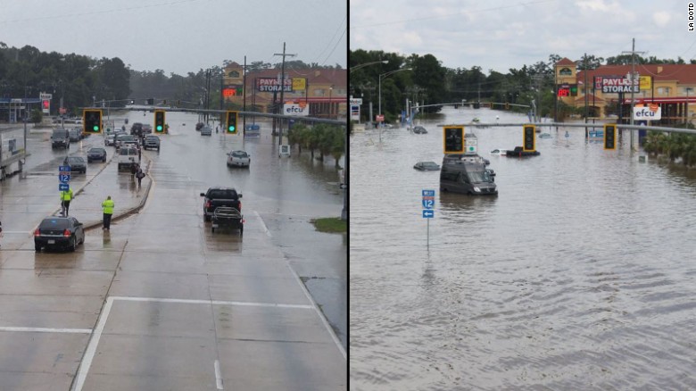
A road in Baton Rouge was relatively dry Saturday but was inundated by Sunday.

Livingston Parish, Louisiana (CNN)The catastrophic flood devastating Louisiana is now the worst natural disaster to strike the United States since Hurricane Sandy four years ago, the Red Cross said.
"Thousands of people in Louisiana have lost everything they own and need our help now," said Brad Kieserman, the Red Cross' vice president of disaster services operations and logistics.
    "This disaster is the worst to hit the United States since Superstorm Sandy, and we anticipate it will cost at least $30 million -- a number which may grow as we learn more about the scope and magnitude of the devastation."
    The calamity struck quickly and ferociously. In one part of Livingston Parish, more than 31 inches of rain fell in 15 hours.
    Louisiana: One family, 13 homes destroyed
    Louisiana: One family, 13 homes destroyed 01:45
    "I bought enough food to last for a week in case we were flooded in, but I wasn't prepared for this much devastation," said Jo Lee Misner, who lives in the Livingston Parish community of Colyell. "Local stores are running low on everything from food to fuel."
    At least 36 of her relatives have lost their homes -- all 13 of them.
    "It's unbelievable what we've been through," she said. "We never imaged this would happen."
    And it's not over. At least 13 people have died across five parishes. And with more rain forecast, the destruction could mount.

    http://www.cnn.com/2016/08/18/us/louisiana-flooding/

    Matthew one of the most powerful Atlantic hurricanes in recent history

    636110037140875351-latestfull.jpg

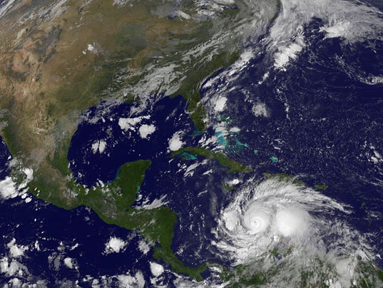
    Hurricane Matthew smashed its way through the Caribbean and roared toward Haiti, Jamaica and Cuba on Sunday, a Category 4 storm powered by 145-mph winds that could pose a threat to the United States by week's end.
    Matthew briefly reached maximum Category 5 status Friday, making it the strongest Atlantic hurricane in almost a decade. Late Sunday, the storm was located about 265 miles south-southeast of Kingston, Jamaica, and was crawling west at 3 mph.
    The latest National Hurricane Center projection had Matthew reaching the southwestern tip of Haiti late Monday, but tropical storm conditions could reach Jamaica and Haiti as soon as late Sunday and eastern Cuba early Monday. The storm was expected to remain a powerful and dangerous hurricane into Tuesday, forecasters said.
    "Preparations to protect life and property should be rushed to completion," the hurricane center warned on its Facebook page.
    Matthew could dump up to 25 inches of rain over much of southern Haiti, with "isolated maximum amounts of 40 inches," the hurricane center warned. Eastern Jamaica, the Dominican Republic and eastern Cuba could see 10 to 20 inches of rain with 25 inches in isolated areas. In addition, storm surges in the region could cause catastrophic flooding.
    Although the official forecast on Sunday showed a track east of Florida, the hurricane center said it was still too soon to rule out possible possible hurricane impacts there — or how Matthew might affect the remainder of the U.S. east coast.
    In Haiti, families were being urged to stock up on food and water, and evacuations were underway in high-risk areas. The Haitian Civil Protection Agency said it had 576 temporary shelters available that can accommodate up to 88,252 people for at least 3 days.
    "This could be catastrophic for some places, particularly Haiti," National Hurricane Center meteorologist Dennis Feltgen told USA TODAY. "This is an area where trees just don't exist (due to deforestation). The terrain is stripped, and the threat of major flash floods and mudslides is very real."

    http://www.usatoday.com/story/weather/2016/10/02/matthewcategory-4-hurricane/91431066/

    Study sees climate change in action in the air, watching carbon dioxide trap heat

    The Associated Press

    By SETH BORENSTEIN, AP Science Writer
    WASHINGTON (AP) — Scientists have witnessed carbon dioxide trapping heat in the atmosphere above the United States, chronicling human-made climate change in action, live in the wild.
    A new study in the journal Nature demonstrates in real-time field measurements what scientists already knew from basic physics, lab tests, numerous simulations, temperature records and dozens of other climatic indicators. They say it confirms the science of climate change and the amount of heat-trapping previously blamed on carbon dioxide.
    Researchers saw "the fingerprint of carbon dioxide" trapping heat, said study author Daniel Feldman of the Lawrence Berkeley National Laboratory in California. He said no one before had quite looked in the atmosphere for this type of specific proof of climate change.
    Feldman and colleagues used a decade of measurements from instruments in Alaska and Oklahoma that looked straight up into the sky and matched what they saw with the precise chemical composition and heat fingerprints of carbon dioxide trapping heat. Scientists say carbon dioxide from the burning of coal, oil and gas is the chief cause of global warming.

    http://stem-works.com/external/article/1187

    From Space, Typhoon Maysak's Eye Looks Like a Black Hole


    The astronauts living and working on the International Space Station are eye to eye with a deadly super typhoon as it heads toward the Philippines. 
    And from more than 200 miles (320 kilometers) above Earth, the mass of clouds swirling around the dark eye of the monster storm Maysak almost resembles the disk of glowing matter being pulled into a black hole.
    "Looking down into the eye - by far the widest one I've seen. It seemed like a black hole from a Sci-Fi movie," NASA astronaut Terry Virts wrote on Twitter. The eye of the storm stretches 17 miles (27 km) across, according to NASA.

    Virts and his fellow astronauts have been posting pictures of the typhoon, which is expected to hit the Philippines this weekend if it doesn't change course.
    "Commands respect even from space," wrote Samantha Cristoforetti, an Italian astronaut with the European Space Agency who launched into space with Virts in November. (The shot of Maysak that Cristoforetti posted on Twitter might look like it's upside down, but astronauts often feel like they're looking up at Earth from inside the Cupola, a seven-windowed room aboard the space station with the best views.)

    http://stem-works.com/external/article/1242