Showing posts with label Curtis Grosse. Show all posts

Sunday, December 11, 2016

Snowing In Paradise

Up to 6 inches of snow fell on the peaks of Hawaii's tropical mountains earlier this week. There were winter storm warnings in place on Mauna Loa and Mauna Kea. There was heavy winds up to 55mph and low visibility in the summits of the islands.

"The conditions will make driving and hiking very dangerous, the NWS warned, with the combination of strong winds and heavy snow making travel potentially 'very hazardous or impossible.' "

"The variation in the island's elevation allows for colder temperatures at higher altitudes -- which can support winter weather precipitation"The summit of Mauna Kea on Hawaii's Big Island was covered in snow Thursday.

Monday, October 10, 2016

Some People are Second-Guessing Before Evacuating Again

After hurricane Matthew passed through Florida, some residents came back to find their homes nearly untouched. They were forced to evacuate due to being in high-risk areas, but the flood waters did not quite reach the levels they expected. Now some residents are skeptical of evacuating. This could lead to deadly consequences in the future. People feel like the storms are just a nuisance if it doesn't absolutely level everything in the area. However, some people are just happy that they have homes to come back to.

"Predictions in Florida called for storm surge of up to 9 feet above normal, with large waves on top of that. While the surge did not quite reach those levels, it did cause flooding and massive beach erosion in places such as St. Augustine and Flagler Beach."

""We are a culture that seems to get angry if the worst-case scenario doesn't happen and we prepare for it," said Marshall Shepherd, director of the University of Georgia Atmospheric Sciences Program. "I am continually baffled at the people that seem to anger that there is not more loss of life and destruction. That is the point of evacuating."

http://abcnews.go.com/US/wireStory/matthew-guess-decision-evacuate-42704613


The World has a New Goal of Having Zero Net Climate Pollution by the end of the Century

The UN recently ratified the Paris Agreement into national law with a majority of countries backing it. The agreement gives the world a goal of having no carbon emissions by 2100. This ensures that we all have a common goal to try and save the planet. A big weakness to this agreement is that it requires voluntary pollution cuts and can't force any single country to reduce carbon emissions by any amount. Luckily the U.S. is in on this agreement, and it would take several years for us to back out.

"Here's why: As of Friday, the Paris Agreement -- which calls for this zeroing-out of net carbon pollution by the end of the century -- had been ratified by 75 parties, including China, the United States and India, the top three polluters. Those 75 parties represent 58.85% of all global greenhouse gas emissions, according to the World Resources Institute. Both of those numbers are critical because the Paris Agreement "comes into force" -- basically, becomes international law -- 30 days after at least 55 countries representing at least 55% of emissions have ratified it."

"The true strength of the Paris Agreement, in my view, is that it sets a tangible goal for climate policy: Limit warming "well below" 2 degrees Celsius, which is measured as a temperature increase since the industrial revolution.
And underlying that goal: Eliminate all net carbon pollution by 2100 ... A weakness: The agreement relies on voluntary pollution-reduction pledges from its members. And if you add all of those up, as they stand, we can expect to warm the atmosphere by 2.7 degrees Celsius -- an unacceptable amount.

http://www.cnn.com/2016/10/07/opinions/sutter-paris-agreement-ratification/index.html


Monday, September 26, 2016

Iowa City is getting ready for Flooding

Flood waters are expected to reach 23 feet Tuesday, which is the second highest recorded flood waters in city history. Miles of levees have been constructed and thousands of sandbags have been laid in preparation. Only about half of the residents in flood zones have been evacuated. Flooding has already started rising up to roads and around the outskirts.

"Yes, city officials said at a Monday news conference. Mayor Ron Corbett said nearly 10 miles of temporary levees have been constructed in just days, and 250,000 sandbags have been filled and placed to protect homes and businesses. More sandbags were being filled Monday to beef up barriers around critical city infrastructure. The Fire Department has staged boats for water rescues on both sides of the river. The American Red Cross has opened two shelters, and a local official said more emergency workers are flying in to help."

"The river crested Saturday night in Waterloo and Cedar Falls, which are about 55 miles upstream from Cedar Rapids. The water levels in Cedar Falls and Waterloo were slightly lower than had been expected, but they still reached levels that were second only to those in 2008."

http://www.foxnews.com/us/2016/09/26/iowa-city-prepares-for-highest-floodwaters-since-2008-record.html


Tropical Storm Developes Over Land

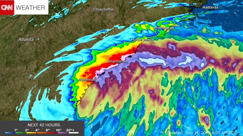
Tropical Storm Julia formed over the state of Florida September 13th. It is extremely rare for a storm to earn the rank of tropical storm while inland, but this storm has done it due to the saturation in the soil. It gained tropical storm force winds for 12 hours which qualified it for official status. It weakened further inland and became a low-pressure system.

"Another interesting phenomenon could also be at play: the "brown ocean" effect, in which a tropical cyclone gains enough energy from a saturated Earth to keep a warm core. It's too early for scientists to know for sure what caused Julia to form over land, but these theories will certainly be researched as a result of this rare formation."

http://www.cnn.com/2016/09/14/us/tropical-storm-julia-weather/index.html


Julia is forecast to dump upwards of 10 inches of rain across the southeast coastline.

Monday, September 19, 2016

Typhoon threatens Recovering areas of Japan

This past Tuesday, a typhoon slammed into Northern Japan. It hit an area still recovering from a tsunami in 2011. Before the typhoon hit it brought winds up to almost 80mph and caused blackouts. It brought over 6 inches of rain and caused mass evacuations. Planes were grounded, and thousands of homes were without power. The strangest part was that this was the first typhoon to hit the Northern side of Japan in 65 years.

"Typhoon Lionrock made landfall near the city of Ofunato, about 310 miles northeast of Tokyo. It's the first time a typhoon has made landfall in the northern region since 1951, when the Japan Meteorological Agency started keeping records."

"More than 170,000 people were subject to evacuation, including 38,000 in Ofunato, according to the Fire and Disaster Management Agency. More than 10,000 homes in the northern region were without electricity, with power lines damaged from the winds"

http://www.foxnews.com/world/2016/08/30/typhoon-slams-japan-threatens-flooding-for-region-battered-by-tsunami.html

Waves crash against a coast in Ishinomaki, Miyagi prefecture, northeastern Japan, Tuesday, Aug. 30, 2016. A typhoon is about to barrel into northern Japan, threatening to bring floods to an area still recovering from the 2011 tsunami. Typhoon Lionrock has already paralyzed traffic, caused blackouts and prompted officials to urge residents to evacuate.(Jun Hirata/Kyodo News via AP)

Why do Hurricanes get Names?

Since 2012 there have been 30 natural disasters without names that have caused over a billion dollars in damage. So why do hurricanes get their own names? Hurricanes used to be named after their coordinates on the globe, but it was very hard to remember a hurricane named " 28°08'55.7"N 67°56'47.0"W". Media started giving storms actual names because it got more attention and allowed people to prepare themselves better. Since it is much more difficult to predict tornadoes, typhoons, and other severe weather several days in advance, there is not much use in a name. With advancing technology though, people are starting to be capable of naming winter storms before they hit.

"Three years ago, The Weather Channel released its own naming criteria for the 2012-2013 winter season. The criteria was simple: Meet the National Weather Service winter-storm warning criteria and be forecast to affect at least 2 million people or more than 400,000 square kilometers — larger than the size of Texas. The weather service issues a winter storm warning when a significant combination of hazardous winter weather is occurring or imminent.
The Weather Channel named one winter storm Nemo in 2013 -- no, not after the cartoon fish, but rather after the Latin definition of the name, which means "no one" or "nobody.""

In Europe there is a program that has named low and high pressure systems for decades.
"Drawing inspiration from military meteorologists, Karla Wege, a student at the Institute for Meteorology of the Free University Berlin, after World War II suggested naming all low- and high- pressure systems throughout Central Europe. This tradition started in 1954 and has continued to this day. Since 2002, anyone can name a European storm through the "Aktion Weeterpate" (Adopt-a-Vortex) program."

http://www.cnn.com/2016/08/22/weather/weather-naming-storms/index.html

Monday, September 5, 2016

Above average Temperatures lead to a Warm Autumn

This fall is predicted to be a hot one for most of the Eastern sea board. The national forecast for the East shows temperatures well above average. It starts to cool down the farther West you go. Even well into October and November the East appears to have above average temperatures. This increased temperature will prolong the changing of the leaves.

"The September through November months are expected to feature near to above-average temperatures across a large swath of the United States, according to an updated fall temperature outlook by The Weather Company, an IBM Business. The East Coast will likely see temperatures the farthest above average."

"According to Dr. Crawford, a weak La NiƱa (cooler-than-average waters off the west coast of South America) could be in play through the fall and winter months, although the horizontal extent of those cooler-than-average waters is expected to be smaller than usual. At the same time, warmer-than-average water temperatures will prevail across much of the North Pacific."


https://weather.com/forecast/national/news/fall-temperature-forecast-update-september-november

Severe Thunderstorms and Flash Flooding threaten mid-west

A moving cold front from the North-West is going to clash with the warm air from the Gulf of Mexico and the jet stream should create severe weather across the Mid-West. There is a chance of an isolated tornado or two. These storms will bring strong winds and some hail. Due to the amount of rain from these storms there is a possibility of flash flooding occurring.

"In addition to the severe threat, flash flooding is also a concern over the next couple of days because any storms that form will have plenty of moisture to work with, due to a southerly wind flow off the Gulf of Mexico, so excessive rain amounts are possible within a short period of time...A broad swath of 1- to 3-inch rain amounts is expected across parts of the northern Plains and Upper Midwest through Wednesday, with isolated areas seeing upwards of 3 to 5 inches. Keep in mind, a lot of this rain may fall in a short period of time, hence the risk of flash flooding."
"The heaviest rain looks to set up over parts of Iowa, Minnesota and Wisconsin."
Tuesday's Thunderstorm Forecast

https://weather.com/storms/severe/news/severe-weather-forecast-midwest-plains-labor-day-2016