Showing posts with label Hannah Spizman. Show all posts

Tuesday, April 28, 2015

Storms, Power Outages Prompt State of Emergency In Parts of Louisiana

Louisiana Gov. Bobby Jindal declared a state of emergency in a handful of parishes after strong storms brought on flooding, and also left thousands of people without power. The rain started early in the day, knocking out power to as many as 200,000 homes and businesses at the height of the storm, according to The Associated Press. Local storm reports showed winds gusting as high as 71 mph at Louis Armstrong New Orleans International Airport as the storms passed through. 
Around the same time is when six to eight freight containers fell off the Huey P. Long Bridge outside New Orleans. A WGNO TV crew recorded it as it happened. No one was hurt and the containers weren't carrying anything hazardous. A tornado was reported by spotters in the Belle Chasse area, local storm reports said.
The National Weather Service said New Orleans saw 1.74 inches of rain, setting a new record for April 27. Earlier in the morning, the westbound lanes of Interstate 10 were closed at Exit 127 due to a fallen tree brought down by the wind, according to the Department of Transportation.

http://www.weather.com/storms/severe/news/louisiana-severe-weather-flooding

6 Ways the Planet's Health Matters for Yours

Heat waves. By most measures, heat is the deadliest type of weather pattern. In particular, extreme heat waves are known to harm low-income urban residents who may not have access to air-conditioning. A 2013 report linked extreme heat specifically to human-caused climate change, reported National Geographic.

Wildfires. The changing climate's heat waves and droughts will lead to increased wildfire outbreaks, if they have not already, according to the Third National Climate Assessment Report from the U.S. Global Change Research Program, released in 2014. (However, direct links between human-caused climate change and past wildfires, up until at least 2013, have been tenuous, according​ to the same National Geographic report.)

Drought and water quality. Declining water supplies, and in turn, reduced agricultural yields are major concerns due to climate change, the Climate Assessment Report found. (That said, natural climatic variability, not necessarily human-caused climate change, could be the largest contributing factor to the California drought, a NOAA report released in 2014 announced.)

Vector-borne diseases. Diseases spread through mosquitoes and ticks killing thousands every year. The number of diseases affecting humans, plus the number of cases, is set to rise. "The climate will get warmer which means non-native species will be able to survive better, mosquitoes will develop at a faster rate and warmer temperatures will permit tropical pathogens to be transmitted and at a faster rate," Dr. Jolyon Medlock from the Emergency Response Department at Public Health England told weather.com in an email after a study about future disease outlooks in the U.K. 
Air pollution. Seven out of 10 doctors consider air pollution to be the top climatic health concern currently affecting individuals in the United States, according to a recent survey. Air pollution is known to cause lung cancer and has been linked to COPD, asthma and other respiratory illnesses, as well as heart attacks and heart disease. Hot, humid air exacerbates these conditions by causing the formation of additional ozone smog in the air. 
Allergies. Not only will a generalized warming trend cause spring allergy season to start earlier and fall to go later, but also the changing climate itself is causing plants to produce more pollen. "The pollen is [directly] affected by greenhouse gases," 
http://www.weather.com/health/news/earth-day-health-and-climate-change 

Why Spring Gets Shorter Every Year

Spring has been getting shorter for thousands of years, but unless you've sat down with an atomic clock and an eye to the skies, you probably haven't noticed. While the first day of spring was marked by the vernal equinox Friday, spring is losing time to summer in the northern hemisphere, and will continue to do so for millenia, astronomers say. This year the vernal equinox occurred at 6:45 p.m. EDT on March 20, at which point the Earth's axis reached a halfway mark and the sun bathed both the Northern and Southern Hemispheres in an equal amount of light, the NWS said. From this point until the summer solstice on June 21, daylight will grow in the Northern Hemisphere and shrink in the Southern Hemisphere
Next year, however, the solstice will come earlier because the Earth wobbles (called precession) on its axis as it orbits the sun, taking a chunk out of spring in the process. As asronomer Larry Gerstman told LiveScience, summer is the longest season this year at 93.65 days. Spring is next at 92.76 days, followed by autumn and winter at 89.84 days and 88.99 days,  respectively.  By 8680, spring will have shrunk to 88.5 days – or over 6,500 years to lose four days. Bad news if you were looking forward to witnessing the change firsthand. "It's not something that anyone is going to notice unless you're an astronomer or a paleoclimatologist," Goddard Institute director Gavin Schmidt told LiveScience. 
http://www.weather.com/science/news/spring-shorter-vernal-equinox-season

El Niño Is Hanging On: What that Means for Hurricanes

Over the next few months, the globe might see an uptick in tropical cyclone activity thanks to an El Niño that is showing signs of asserting itself more forcefully. That doesn’t mean more hurricanes everywhere, though: While El Niño tends to boost activity in the Pacific Ocean, it clamps down on storm formation in the tropical Atlantic. That link has at least one hurricane forecaster calling for a very quiet Atlantic hurricane season this year — possibly the quietest since the mid-20th century. While El Niño is a cyclical climate phenomenon in the Pacific Ocean — marked by warmer ocean temperatures in the tropics and a weakening of the usual easterly trade winds — it can impact weather around the globe.
During an El Niño, a domino of atmospheric effects causes a large area of stable, subsiding air to form over the tropical Atlantic. Exactly the opposite of what a fledgling tropical cyclone, which thrives on instability, needs to grow and strengthen. El Niño also tends to bring more wind shear to the region, meaning the speed and direction of the wind changes more between different altitudes, putting the kibosh on a burgeoning storm.
http://www.weather.com/science/news/el-nino-strength-what-that-means-for-hurricanes


Thawing Permafrost Will ‘Seep, Not Explode’ CO2

The Arctic holds more than a trillion tons of carbon, locked in the frozen soil known as permafrost. That’s more than twice as much carbon as there is in the atmosphere itself, according to a 2013 report from the National Academy of Sciences. And as the climate warms under its growing blanket of human-generated greenhouse gases, thawing permafrost could release some of that carbon into the atmosphere.
That could amplify the effect of global warming by boosting CO2 levels higher than they would otherwise be in a so-called feedback loop and making the consequence of warming, including rising seas, more intense and prolonged heat waves and droughts and distorted weather patterns even more severe. They could also lead to more thawing of permafrost and the release of even more CO2, starting the cycle again.
How much carbon will be released, however, and how much extra warming is likely to result, has been a matter of dispute in recent years. Some researchers have argued that that the effects will be horrific, while others say they’ll be significant but less dramatic. And now, a new report in Nature — the most comprehensive study ever done on the permafrost feedback loop, has come down firmly in the “significant” camp. “The permafrost carbon is not going to explode into the atmosphere catastrophically within just a few years,” Ted Schuur, a permafrost expert at Northern Arizona University, said. “It’s more like it will seep out slowly in small amounts in a very large number of places.”
http://www.weather.com/science/environment/news/thawing-permafrost-climate-threat

Night Tornadoes Are Particularly Deadly

The only thing more frightening than the sight and sound of a tornado approaching is one that strikes while you're asleep. It comes in the middle of the night, enveloping your neighborhood with dangerous winds, swirling debris, and possibly deadly consequences. 

Nocturnal tornadoes, as they are called, are like nightmares that have come to life. They strike under the cover of darkness and are often among the most deadly weather phenomenon. 
"Nocturnal tornadoes are particularly dangerous for several reasons," says Dr. Greg Forbes (find him on Facebook), severe weather expert at The Weather Channel. "One is that it’s nearly impossible to see the tornado coming, so getting and heeding warnings is crucial. Another is that people are often asleep and caught unaware. People are usually at home, often in structures that are not as sturdy as their place of work. Mobile homes are particularly vulnerable." 
As spring severe weather season kicks into high gear, night tornadoes are a great concern. 
http://www.weather.com/storms/tornado/news/night-tornadoes-deadly-20130318

Fairdale, Illinois, Residents Allowed To Return To Tornado-Devastated Town Days After EF4 Strikes

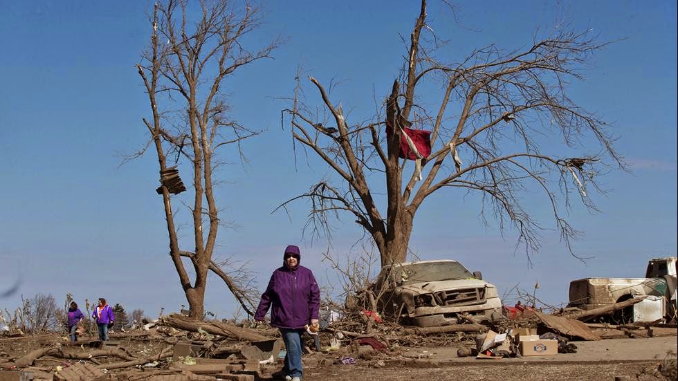
Two days after a massive EF4 tornado devastated the town of Fairdale, Illinois, residents were allowed back into their homes to survey the damage and salvage any treasured belongings that weren't taken by the storm.
The residents of the small farming town were bused in by the DeKalb County Sheriff's Office at 7 a.m. Saturday, less than 48 hours after the half-mile-wide twister wrecked homes, tossed cars into the air and killed two people. When they returned and the sad reality of the damage's scope set in, some residents simply couldn't believe they survived the storm.
"I thought my parents were dead," said 32-year-old Adam Davis, who hopped into his truck Thursday and raced along with the tornado in the hopes of getting to his parents' house and rescuing them before the twister struck. He found them standing in their doorway frozen in disbelief and grabbed them just in time.
http://www.weather.com/storms/tornado/news/fairdale-tornado-residents-return

Kansas Turnpike Tornado Shelters Offer Another Option For Severe Weather Safety

Along the Kansas Turnpike are 30 doors that might not look like much, but inside those doors are storm shelters that may save dozens of lives someday.
That's the hope of the Kansas Turnpike Authority, who installed these fortified underground bunkers along the 236-mile-long highway as a last-ditch option for drivers caught in the severe weather of Tornado Alley.
Each of these shelters can hold roughly 15 people, according to Fox4KC.com, while additional shelters located under some toll booths can hold more than that.
"We have tornado shelters at all of the plazas, and they're mainly for our employees and any customers that would be in the general area," Kansas Highway Patrol Master Trooper Karl Koenig told Fox4KC.com. "Simply open them up by a door, there's steps to go down in there, and there's a small wind turbine on top that provides air when the doors shut."
http://www.weather.com/safety/tornado/news/kansas-turnpike-tornado-shelters 

A Tropical Storm in April? It's Not Unheard Of

The Atlantic hurricane season officially stretches from June through November. 
However, one tropical storm this century flared up in the Atlantic basin in late April.
On April 20, 2003, Tropical Storm Ana became the only tropical storm on record to form in the 
Atlantic basin in April.
That early in the calendar, "April Ana" didn't form from a tropical wave coming off west Africa. It
 formed as an area of low pressure aloft spinning near an old surface frontal boundary 
about 250 miles west of Bermuda.
Eventually, thunderstorms began clustering near the surface low, warming and moistening 
the low-mid levels of the atmosphere sufficiently enough for the National Hurricane Center to classify
 the storm as Subtropical Storm Ana during the early-morning hours of April 20.
Based on microwave satellite imagery, it was estimated Ana became the first April Atlantic tropical storm of 
record later on April 20, when it exhibited enough consolidated thunderstorms near the center.
http://www.weather.com/storms/hurricane/news/april-tropical-storm-ana-2003 

Severe Weather Threat Confined to Gulf Coast, Florida

Severe thunderstorms capable of producing large hail, damaging winds, tornadoes and flooding rainfall will flare up through Wednesday in parts of the Gulf Coast states.
Severe weather expert, Dr. Greg Forbes, estimates 48 tornadoes have occurred in five states since Friday. The Storm Prediction Center and local NWS offices have received 575 reports of severe weather since Friday morning, mainly across this hard-hit strip of the South.  
Monday, a squall line roared through the New Orleans metro, blowing train cars off the Huey P. Long Bridge and spawning a brief EF1 tornado in Jefferson Parish near Kenner. At its peak, just over 200,000 customers were without power in Lousiana and east Texas from thunderstorm winds.
Hail up to golf ball size (1.75 inches in diameter) was reported Monday evening in Florida, including Lake Placid, Stuart and near Okeechobee as a severe thunderstorm moved through.
http://www.weather.com/storms/tornado/news/severe-weather-tracker-page

Birth of a New Iceberg

Satellite imagery from NASA captured the birth of a new iceberg near Antarctica late this past winter.
The series of three images in the animation above show the 17-mile-long (27 kilometers) iceberg breaking off of the Getz Ice Shelf in western Antarctica from Feb. 16, 2015 to March 5, 2015.
It was discovered by the U.S. National Ice Center (NIC) and was given the name B-34 since it exceeds the 19-kilometer-long size requirement needed for tracking. According to NASA, the B-34 name is derived from the fact that this iceberg is the 34th to come from the B quadrant of Antarctica.
NASA says that the cold, fresh water from melting large icebergs can affect ocean currents and circulations in the Southern Ocean.
http://www.weather.com/science/environment/news/iceberg-debut-nasa-antarctica

Your Odds of Being Hit By a Tornado

If you simply examined a map of all U.S. tornado tracks from 1950-2014, you might conclude your odds are disconcertingly high in the nation's mid-section and South.
Certainly, those are the tornado hot zones well known by most. Oklahoma, Arkansas, Kansas, Texas, Alabama and Mississippi may first come to mind.
The advance of technology such as Doppler and dual-polarization radar, cellular networks, smartphones, as well as a far greater number of storm spotters and the general increase in population means more weak tornadoes (EF0, EF1) are detected or observed today than, say, in the 1960s. This is known as "tornado inflation."
http://www.weather.com/storms/tornado/news/tornado-odds-of-being-hit


Poll: 52 Percent of Americans Worried about Climate Change, Yet Few Give the Issue Top Priority

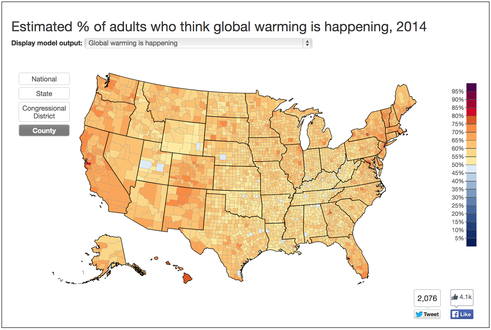
The Yale researchers developed a statistical model to look at public opinion surrounding climate change at the state and city level. It intentionally gets pretty granular: “Although a majority of people in every state think global warming is happening, this analysis makes it possible to see how much opinions differ within each state,” Utah State’s Peter Howe said in a news release. 
Interestingly, 63 percent of people think global warming is real, but just 48 percent say they believe it’s “mostly human caused.” Fifty-two percent of Americans are worried about climate change, and a similar percentage say it will affect people in the United States, but just 34 percent say it will touch their lives specifically. (For more results from the Yale study, click here.) “We have become so used to hearing a single number that represents what Americans think about this issue that just seeing the great diversity across the country was really surprising,” Jennifer Marlon, Ph.D., one of the Yale researchers who helped develop the model, told weather.com. 
The Saint Leo poll puts the issue in a broader context. Of the 1,016 individuals who answered the survey, just 3 percent picked global climate change as “the most important issue facing the country today,” placing the topic well below jobs/economy and immigration, just above gun control. About one-third said climate change caused each of the following: warmer temperatures, more severe weather, terrible drought and increased ocean flooding.
http://www.weather.com/science/environment/news/majority-americans-worried-climate-change 

Lightning Strikes One World Trade Center in Stunning Earth Day 2015 Display

Mother Nature's magnificent power was on full display when lightning struck One World Trade Center in New York City during late afternoon storms Wednesday, on Earth Day.
As skies darkened, New York amateur photographer Max Giuliani captured the remarkable moment when the lightning bolt struck the top of the skyscraper. "Whenever there is a thunderstorm in the area, I grab my camera and hit Hudson River Park," he told the New York Daily News.
Despite how threatening Giuliani's photograph appears, a Port Authority spokeswoman told the Daily News there was no damage to the building. 
http://www.weather.com/news/news/new-york-one-world-trade-center-lightning-strike-earth-day-2015

Rainbow Ice Caves in Russia Are Unlike Anything You've Seen

It's unlike anything you've ever seen: rainbows 'trapped' in ice. These colorful ice caves, formed by heavy winter snows and carved by summer melting in southern Kamchatka, Russia, could collapse at any moment.  
"It was pretty cold and wet inside and the water was flowing down from the roof and walls," Budkov told the media. "It was zero degrees inside, too, and the lens was getting damp – making it hard to shoot."
"When I got deeper inside the caves, I was amazed by the colors I saw. I haven’t seen anything like this before," Budkov said. "The emerald colors of the ice were spectacular and worth the risk of the roof caving in to capture the pictures."
The myriad colors are created by light reflecting through the ice, with the most colorful sections consisting of thicker ice, Metro says. 
http://www.weather.com/science/nature/news/russian-photographer-dennis-budkov-rainbows-trapped-ice-caves-russia


Shelf Clouds: Not Tornadoes, But Still Scary and Ominous

Shelf clouds are typically seen at the leading edge of a thunderstorm or squall line of thunderstorms. While menacing in appearance, shelf clouds are not tornadoes or wall clouds.
What you're seeing in a shelf cloud is the boundary between a downdraft and updraft of a thunderstorm or line of thunderstorms.
Rain-chilled air descends in a thunderstorm's downdraft, then spreads laterally when reaching Earth's surface. Warmer, more moist air is lifted at the leading edge, or gust front, of this rain-cooled air. When this warm, moist air condenses, you see the shelf cloud.
As the shelf cloud passes, you feel an abrupt shift in wind direction and increased wind speed, followed within minutes by heavy rain or hail. Wind gusts once the shelf cloud has passed may be quite strong, causing downed trees, tree limbs and power outages.
http://www.weather.com/science/news/shelf-cloud-photos-20130412 

Monday, April 27, 2015

Destructive Illinois Tornado Kills at Least Two; 15 Severe Weather Watches Issued

Family and friends of Dave Schabacker assist with cleanup Friday morning, April 10, 2015, after his home was destroyed the night before in Rochelle, Ill. At least two tornadoes swept through Illinois late Thursday. (AP Photo/Rockford Register Star, Sunny Strader)  
  • SPC issued seven tornado watches and eight severe thunderstorm watches Thursday and Thursday night – by far the most so far in 2015.
  • Late Thursday evening, the Illinois Office of Emergency Management said one person was killed in Fairdale, a small DeKalb County hamlet that took a direct hit. (The death toll rose to two on Friday.) Three people were injured in DeKalb County and four more in neighboring Ogle County, where a restaurant collapsed north of Rochelle. Rescue crews continue to sift through debris.
  • A large, long-track tornado began near Ashton, Illinois, around 6:40 p.m. CDT Thursday. It crossed Interstate 39 several miles north of Rochelle, Illinois, shortly after 7 p.m. CDT. The tornado was broadcast live on The Weather Channel. Fairdale was hit shortly afterward. The parent storm continued to spawn a tornado – possibly the same tornado – all the way northeast into McHenry County in the far northwest suburbs of Chicago, where it was sighted near Marengo and Harvard before eventually weakening and dissipating as it approached the Wisconsin border.    
  • http://www.weather.com/storms/tornado/news/tornado-severe-threat-chicago-illinois-missouri-indiana-ohio-april-9-2015

The Enhanced Fujita Scale: How Tornadoes are Rated

The original Fujita scale is named after Dr. Ted Fujita, a University of Chicago severe storms research scientist who came up with the scale in 1971. Dr. Fujita's scale, which ranges from F0 to F5, is based upon the type and severity of damage the tornado produced. At that time, there were very few actual measurements of tornado wind speeds that he could relate to the damage, but he used them -- together with a lot of insight -- to devise approximate wind speed ranges for each damage category.
In subsequent years, structural engineers and meteorologists have examined damage from many tornadoes. They use knowledge of the wind forces needed to damage or destroy various buildings and their components to estimate the resultant wind speeds. The engineers and scientists eventually determined that the original F-Scale wind speeds were too high for categories F3 and higher.
http://www.weather.com/storms/tornado/news/enhanced-fujita-scale-20130206

Why April Is a Dangerous Month for Tornadoes

An average April jet stream is strongest over the southern U.S., over that warm and humid air.  
A common outbreak scenario involves a pronounced southward dip in the jet stream, or upper-level trough, that plows east into the Plains or South with winds aloft spreading apart, forcing strong upward vertical motion in the atmosphere.  
The jet stream also provides deep wind shear, or changing wind speed and direction with height, supportive of rotating supercell thunderstorms.  
If wind shear is particularly strong in the first few thousand feet near the surface, these supercells would more likely produce tornadoes. 
http://www.weather.com/storms/tornado/news/april-tornadoes-history-explained 

Snowy, Rain, Foggy System Hits Rockies; Weather Blamed for Bus Crash near Denver

A slow-moving storm that slammed into the Rockies late this week is now blamed for contributing to a chain-reaction crash on a wet stretch of I-70 near Denver Friday.
The fog was part of an overall system that brought snow into Denver and the rest of the Rockies region. We're not just talking about the mountains either. Salt Lake City saw 5.8 inches of snow late Tuesday night through Wednesday.
While roads in the city of Denver remained mainly wet due to warm ground temperatures and air temperatures in the low-mid 30s, 4.1 inches of snowfall was measured at the airport by Friday morning before precipitation turned to rain in the city.
Unfortunately, heavy snow and whiteout conditions contributed to a pileup of at least 60 vehicles on a stretch of Interstate 80 between Laramie and Cheyenne, Wyoming Thursday. Cheyenne had picked up 5.2 inches of snow through midnight Thursday night and up to 9 inches of snow was measured in Laramie, Wyoming as of early Thursday evening. Poor conditions lasted into Friday afternoon, leaving I-80 shutdown well over 20 hours.
http://www.weather.com/storms/winter/news/spring-snow-rockies-colorado-utah-wyoming-denver 
Part of a tour bus involved in an accident with a tractor trailer sits in a westbound lane of Interstate 70 Friday, April 17, 2015, in Aurora, Colo. (AP Photo/David Zalubowski)