Showing posts with label Prince Ikerodah. Show all posts

Tuesday, December 6, 2016

Widespread, Significant Lake-Efeect Snow in Forecast Late this week

Widespread, Significant Lake-Effect Snow in Forecast Late This Week

As arctic air invades the Lower 48 states and spreads eastward through the week, lake-effect snow showers and squalls will likely develop downwind of the Great Lakes beginning late Wednesday or Thursday.
An upper-level low-pressure system will set up over southern Canada, spinning bitterly cold west to northwest winds over the relatively warmer Great Lakes.
For lake-effect snow to develop, the air temperature about 5,000 feet above the surface must be at least 23 degrees Fahrenheit (13 degrees Celsius) colder than the lake temperature. 
The temperatures of the Great Lakes are currently in the 40s, and this incoming arctic air mass will be more than cold enough to irritate the mild lakes.
In fact, lake temperatures are running warmer than they have at this time each of the last five years, according to NOAA's Great Lakes Environmental Research Laboratory. 
The cold, dry air will pick up moisture and heat from the lakes, which will condense into clouds and dump snow downwind of the lakes.
Some localized, intense snow bands may form, especially off Lakes Erie and Ontario, due to an upwind connection with the upper Great Lakes and possibly even the Hudson Bay at times.
https://www.wunderground.com/news/lake-effect-snow-forecast-great-lakes-early-december-2016

Monday, November 14, 2016

2015 Record Breaking Temp. May be the Norm by 2025

2015's Record-Breaking Temperature May Be the Norm by 2025

The year 2015 saw the hottest temperature on record globally but in less than a decade, this may just be another year. A research published by the Bulletin of American Meteorological Society reveals that human activities had already locked in a "new normal" for global average temperatures that would occur no later than 2040.
Lead author Dr. Sophie Lewis from the Australian National University hub of the ARC Centre of Excellence for Climate System Science stated, "If we continue with business-as-usual emissions, extreme seasons will inevitably become the norm within decades and Australia will be the canary in the coal mine that will experience this change first."
But Dr. Lewis doesn't think the situation is completely without hope. Though annual global average temperatures were locked in, it would still be possible with immediate and strong action on controlling carbon emissions to prevent record-breaking seasons from becoming average, at least at regional levels. "If we reduce emissions drastically to the lowest pathway recommended by the Intergovernmental Panel of Climate Change, then we will never enter a new normal state for extreme seasons at a regional level in the 21st Century," Dr. Lewis said.
Dr. Lewis and her colleagues have now developed a scientific definition for the term 'new normal' as this is the cornerstone of their new research. "Based on a specific starting point, we determined a new normal occurred when at least half of the years following a record year were cooler and half warmer. Only then can a new normal state be declared," she said.
The researchers, in an effort to determine when new normal states would appear under the Intergovernmental Panel for Climate Change's four emissions pathways, used the National Computational Infrastructure supercomputer at Australian National University to run climate models. Results showed that though global average temperatures would inevitably enter a new normal under all emissions scenarios, this wasn't the case at seasonal and regional levels.
"It gives us hope to know that if we act quickly to reduce greenhouse gases, seasonal extremes might never enter a new normal state in the 21st Century at regional levels for the Southern Hemisphere summer and Northern Hemisphere winter," Dr Lewis stated.
http://www.natureworldnews.com/articles/31672/20161111/getting-hot-here-2015s-record-breaking-temperature-norm-2025.htm

Thursday, October 20, 2016

Cold,windy,rainy,and snowy-in Northwest

Cold, windy, rainy and snowy — this is the Northeast weekend weather forecast


After nearly a week of sunshine and warm winds from the south, a giant trough is going to change things up in the Northeast this weekend. Like it or not. For some, overnight lows will drop below freezing by early next week, and the first snowfall of the season is possible in the New England mountains. (U.S. Drought Monitor/weatherbell.com)

Why isn't the U.S Better at a Predicting Extreme Weather

Why Isn’t the U.S. Better at Predicting Extreme Weather?

http://www.nytimes.com/2016/10/23/magazine/why-isnt-the-us-better-at-predicting-extreme-weather.html


"Last year, he notes, the Air Force began paying Britain’s Met Office $100,000 a year to license its weather-modeling software. “That a U.S. government agency has decided that our capability is not good enough is pretty amazing,” he says. On his blog, he’s not shy about criticizing federal agencies in post-mortems after storms, often singling out the National Centers for Environmental Prediction.William Lapenta, who heads the centers, welcomes the criticism: “His job through his blog is quite honestly to provoke people to respond and hopefully take action,” he says. Indeed, Lapenta told me that the National Centers for Environmental Prediction, which directs the National Hurricane Center, might never have obtained additional funding from Congress to buy new supercomputers had Mass not drawn public attention to the center’s inadequacies in the aftermath of Hurricane Sandy."

Winter Storm Names 2016-2017

Winter Storm Names For 2016-2017 Revealed

The Weather Channel and weather.com on Tuesday released its winter storm names for the 2016-2017 season, marking the fifth season of naming winter storms. The names will be used in alphabetical order to identify winter storms that meet naming criteria. The 2012-2013 list for winter storms was the first of its kind to be developed by The Weather Channel.
 "It's simply easier to communicate about a complex storm if it has a name, which our naming program has demonstrated," said Bryan Norcross, senior hurricane specialist at The Weather Channel and compiler of the list. "Good communications benefits everyone."

(AMS BLOG: It's Time For Weather Community Cooperation on Naming Winter Storms)
According to winter weather expert Tom Niziol of The Weather Channel, there were 22 named winter storms in the 2015-2016 season, matching the total from the 2014-2015 season, but less than the 26 named storms in 2013-2014 and 27 storms in 2012-2013.

(RECAPS: Winter 2015-2016 Warmest on Record in Lower 48 States)
The Bozeman, Montana, High School Latin class, which has contributed to the winter storm name list since 2013-2014, once again contributed to the 2016-2017 list.

The roster of winter storm names for the 2016-2017 season, compiled by Bryan Norcross of The Weather Channel in collaboration with the Bozeman High School Latin class.

Full Article Here 

Typhoon Haima- Northern Philippines

Typhoon Haima (Lawin) Makes Landfall in the Northern Philippines With 140 MPH Winds


https://weather.com/storms/typhoon/news/super-typhoon-haima-lawin-philippines-china-forecast

"Typhoon Haima has made landfall in the northern Philippines as a Category 4, making it the second typhoon of that intensity to strike the area in just a few days time. Late this week, Haima will make a second landfall in southeast China.
PAGASA - the Philippine Atmospheric, Geophysical and Astronomical Service Administration - said that the center of Haima, known as "Lawin" in the Philippines, came ashore around 11:00 p.m. local time Wednesday near Baguio Point in the Cagayan Province. Maximum sustained winds were 140 mph at that time, according to an advisory issued by the Joint Typhoon Warning Center.
After topping out at Category 5 intensity late Tuesday-early Wednesday, Haima weakened some just before making landfall on northern Luzon Island. It remains a powerful and destructive typhoon, however."

h

Saturday, October 1, 2016

South Australia Falling Victim to Storms

South Australia Falling Victim To Storms

Southern Australia is becoming beckoned with water. The city of Port Pirie has been flooded. The town of Sevenhill has been warned of their dam weakening. Victoria, New South Wales, the ACT, Tasmania, and South Australia have all received severe weather warnings. The storm is reported to be one of the worst in 50 years. 80,000 lightning strikes have been reported with 22 transmission towers flying from the ground. 30,000 residents are without power, with the threat continuing in South Australia. Winds ranging from 50 to 140 km/hr have been reported. Sea levels have been reported to be slightly rising. Combining with the wind conditions shall result in coastal erosion and damage.

http://www.news.com.au/technology/environment/almost-the-entire-south-east-corner-of-australia-under-severe-weather-warnings/news-story/093893a832c03638faa73981bc7c27e0

Saturday, September 17, 2016

Super - Typhoon

Super-Typhoon in Taiwan

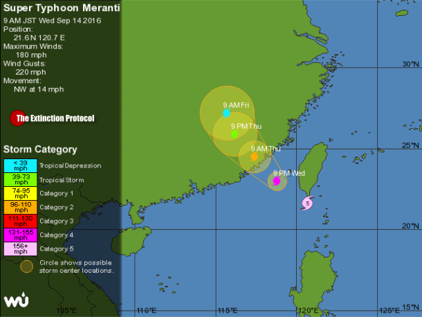
September 2016 – TAIPEI, Taiwan – Record-breaking winds and heavy rains disrupted transport today as Super-Typhoon Meranti cut a path across southern Taiwan and headed toward China. Toppled trees and storefront signs were strewn about a thoroughfare in Kenting National Park’s Hengchun Township, images on Taipei-based Sanlih E-Television showed. Wind speeds of 52.2 meters per second (117 miles per hour) were the fastest since record-keeping began in 1896, according to the Taipei-based Apple Daily. Schools, offices and markets remained open in the capital of Taipei.

Sunday, September 11, 2016

Heating, air moves and low pressure center


What Fueled Louisiana’s Deadly Flood?

"[I]n regions such as southern Louisiana and the Everglades, shallow warm water permits heating to still occur as air moves towards the low pressure center. This mimicking of aspects of the ocean conditions, including the evaporation of water vapor into the system, permits tropical systems to persist longer than they otherwise would. This is what occurred in this Louisiana deluge. "

http://dotearth.blogs.nytimes.com/2016/08/17/how-an-inland-brown-ocean-and-climate-change-may-have-fueled-louisianas-deadly-flood/?rref=collection%2Ftimestopic%2FWeather&action=click&contentCollection=timestopics&region=stream&module=stream_unit&version=latest&contentPlacement=7&pgtype=collection&_r=0

Supercells

What are Supercells?
A supercell is a thunderstorm with a deep, persistently rotating updraft.
Supercells are the least common form of thunderstorm yet they are potentially the most violent. Large hail of greater than baseball size, strong damaging winds, and tornadoes can accompany these storms.
To storm chasers, Supercells are the grand catch — they are the bounty which storm chasers most commonly hunt for.

SUPERCELL AFTERMATH!

Heat wave in Russia

Heat Wave in Russia

MOSCOW — Thirteen members of a nomadic Siberian community have been hospitalized after a heat wave thawed the carcass of an anthrax-infected reindeer and sparked an outbreak of the disease.
Around 1,500 of the animals have died from the highly infectious disease since Sunday, the government of Russia's Yamalo-Nenets autonomous district announced on its website Tuesday. A state of emergency has been imposed throughout the region in western Siberia due to the incident — the first of its kind since 1941.


Iceland Volcano


White-Hot Show at Iceland Volcano
A blast of white-hot lightning crackles over Iceland's Eyjafjallajökull volcanoon Sunday. Clouds of volcanic ash from Eyjafjallajökull h