The forecast track prediction is equally difficult. So far the track has been pretty close to what was expected because it has been a very straightforward pattern in the atmosphere.
However, the pattern will change in a big way in a few days. A cold front will start to draw Florence toward it but the big question is whether or not it will be strong enough to maintain its grip on the hurricane and keep it moving out to sea.
When a front just barely gets a grip on a hurricane it will start to pull it in and then lose its grip. That allows the storm to drop back and wait for the next front. Sometimes if high pressure moves in behind the cold front it can stop a storm from advancing, and push it off to the west into the East Coast. When you look at past storm tracks and notice complete loops that is what happened
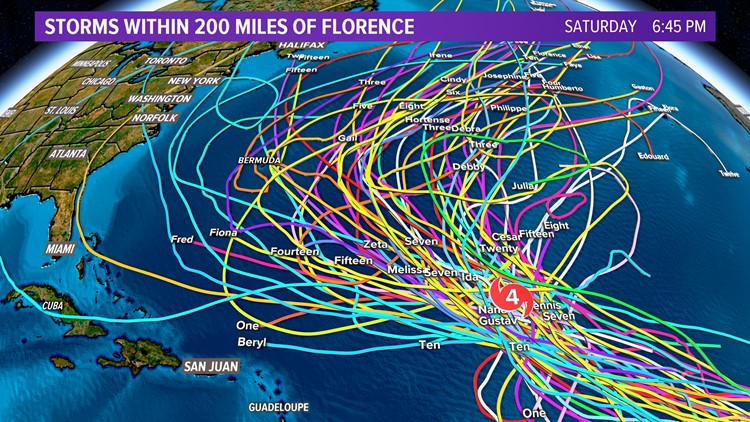
One thing that meteorologists like to do is to look at past history. If a storm has always moved toward a specific area after being in a certain position in the Atlantic then we have to take that into account.
The same thing goes for a storm that is in a specific position but has never headed somewhere (like into Hampton Roads). If you look at all the storms in recorded weather history only a very few have ever been as far north as Florence and hit near Hampton Roads.
Unfortunately, that storm was Isabel which blasted the region. Another way to look at it though is that the odds are very much on our side since only one storm has ever hurt us from Florence’s current position.
Another major factor when looking at the difference between Isabel and Florence is that the upper-level winds ahead of Isabelle did not change much and the forecast even from as much as a week ahead of time was very consistent. In this case, we do not have that. One model run will show a cold front picking up the storm and keeping it harmlessly out to sea, only to be followed 12 hours later by the same model showing the cold front losing its grip on Florence and the following area of high pressure pushing the storm back near us.
https://www.13newsnow.com/article/weather/hurricane-center/hurricane-florence-update-and-explainer/291-591269919
No comments:
Post a Comment