Showing posts with label Gabrielle Onyema. Show all posts

Monday, October 26, 2015

"California mudslides leave state reeling as hundreds of cars remain stuck"

ARTICLE: A section of southern California found itself waist-deep in mud as the weekend arrived, and a highway overtaken by flowing debris looked like a buried junkyard of hundreds of cars that would likely take days to dig up.
The worst of the thunderstorms had passed, but the continued chance of rain could dampen cleanup and relief efforts in northern Los Angeles County’s Antelope Valley, where the most serious slides occurred.
On Friday, rescuers and those stranded in the highway debris flow described a chaotic scene that somehow left no reported injuries or deaths.
“It was terrifying,” 51-year-old Rhonda Flores of Bakersfield told the Associated Press. “It was a raging river of mud. I’ve never experienced anything like it, ever.”
Rescuers threw ladders and tarps across mud up to 6ft deep to help the hundreds of trapped people from cars that got caught in the roiling river of mud along State Route 58 about 30 miles east of Bakersfield, a major trucking route, California highway patrol officials said.
They were rescued in darkness about 10 hours after the storm hit and taken to three shelters.
Flores said she, her mother and her stepfather were driving back to Bakersfield from her sister’s funeral in Utah when the storm hit out of nowhere.
Sgt Mario Lopez, a spokesman for the California highway patrol, was at the scene as people were being rescued and said it was sheer chaos.
SUMMARY: It is believed the drought helped cause this: California got a huge influx of rain, so much so, that numerous landslides were caused and piled up lots of traffic, trapping people on the roads. The mud was nearly six feet deep and became a sort of "mud river". Rescuers had to show up and many drivers were terrified.
LINK: http://www.theguardian.com/us-news/2015/oct/17/california-mudslides-cars-stuck-photo-video-cleanup

"Typhoon Koppu weaker but still dangerous, says Philippines government"

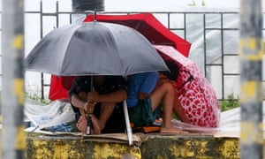
Manila residents huddle under their umbrellas as Typhoon Koppu hits.

ARTICLE: Typhoon Koppu has weakened after blowing ashore in the north-easternPhilippines, but not before it left at least two people dead, displaced 16,000 villagers and knocked out power in entire provinces, officials said.
Troops and police officers were deployed to rescue residents trapped in flooded villages in the provinces of Aurora, where the typhoon made landfall early on Sunday, and Nueva Ecija, where floodwaters swamped rice farmlands during harvest.
After slamming into the town of Casiguran after midnight on Saturday, the typhoon weakened and slowed down, hemmed in by the Sierra Madre mountain range and a high pressure area in the country’s north, and another typhoon far out in the Pacific, said Gladys Saludes of the Philippine Atmospheric, Geophysical and Astronomical Services Administration (Pagasa).
Howling winds knocked down trees and electricity posts, leaving nine provinces without power, while floods and small landslides made 25 roads and bridges impassable. Authorities suspended dozens of flights and sea voyages, and many schools cancelled Monday classes.

SUMMARY: The Philippines, a large series of Asian islands, suffered from their annual typhoons. This one in particular, Koppu, was very strong and displaced people as well as killed a few. Many people were trapped in villages due to floodwaters and crops were ruined due to the extra rainfall. The typhoon weakened as it passed over a high pressure area near a mountain range.

LINK: http://www.theguardian.com/world/2015/oct/18/philippines-typhoon-koppu-weakens-after-fatalities

"Mexico at risk of flash floods and mudslides in wake of hurricane Patricia"

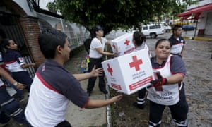
Red Cross volunteers load humanitarian aid boxes from a truck in the Pacific beach resort of Puerto Vallarta, Mexico, on Saturday.

ARTICLEHurricane Patricia battered the west coast of Mexico on Friday night with torrential rains and winds of 165mph, but without causing any major damage or loss of life.
Around 50,000 people were evacuated and electricity supplies were suspended in preparation for the Category 5 hurricane, amid fears of catastrophic destruction in towns along the country’s Pacific coast.
But Patricia rapidly weakened over land as it collided with the Sierra Madre mountain range. On Saturday morning it was downgraded to a tropical storm as winds dropped to 50mph.
As people prepared for the worst, homes and shop fronts were barricaded, airports closed and thousands evacuated from the popular beach resort of Puerto Vallarta in Jalisco. The town escaped any major damage.
“We had pretty steady, fairly heavy rain most of the night, but not a tremendous amount of wind, and there’s really been no damage,” Paul Crist, owner of the Mercurio Hotel one block off the beach in Vallarta, told the Guardian. “We were very, very lucky.
SUMMARY: Hurricane Patricia disrupted the coast of Mexico with severe winds and rain, but apparently no one died. Mexico must have prepared ahead of time and I saw several news reports of speedy evacuations beforehand. Looks like the government there is doing a better job than Nagin from Louisiana ever did during the Katrina hurricane. It went from category 5 and dropped very quickly. There was little damage as well.

LINK: http://www.theguardian.com/world/2015/oct/24/hurricane-patricia-mexico-evacuations-tropical-storm

"Pakistan and Afghanistan rocked by earthquake"


ARTICLE: A major earthquake has hit Afghanistan, northern Pakistan and parts of India, with reports that more than 180 have been killed. The magnitude 7.5 quake was centred in the province of Badakhshan in the Hindu Kush mountain range in Afghanistan’s far north, and occurred at a depth of 130 miles (210km). More than two minutes of sustained tremors were felt in the Pakistani capital of Islamabad. The quake also hit the cities of Lahore, Faisalabad and the mountainous region of Chitral.
     Officials said at least 147 people were known to have been killed in Pakistan and 33 in Afghanistan. Twelve students died while trying to escape from a girls’ school in Taloqan, north-east Afghanistan, and six people died in the eastern province of Nangarhar. A police official in Badakhshan said dozens of houses were destroyed in two remote and sparsely populated rural districts, with some damage reported in Fayzabad. As night falls in the region, further reports of deaths are expected.

SUMMARY: A very large earthquake hit Pakistan and several were injured as well as killed. Other areas near Pakistan felt the two-minute quakes as well. The Pakistani prime minster stated the quakes were stronger than anything they'd received in a long time, and was heading for Pakistan to assess the damage. India said it would provide assistance. Afghanistan suffered bad aftershocks as well.

LINKhttp://www.theguardian.com/world/live/2015/oct/26/earthquake-pakistan-india-and-afghanistan-live-updates

"Thousands Without Power in Louisiana as Gulf Coast Hammered by Heavy Rain"

Rainfall Reports

ARTICLEAfter days of flooding swamped towns in Texas, authorities in San Antonio got good news Sunday afternoon.
A 41-year-old homeless man who was swept away by floodwaters was located more than a day after rushing water swept him away, according to News 4 San Antonio. Roel Martinez was caught in the raging water when he chased after his dog, officials said, and after several hours, the search was called off due to unsafe conditions, the San Antonio Express-News reported.
More than 24 hours later, Martinez was located. He was treated for minor injuries and released from the hospital, News 4 San Antonio added.
"You can call it luck, you can call it blessed, you can call it all of those things," San Antonio Fire Department Chief Charles Hood told News 4 San Antonio.
In Louisiana, thousands lost power in Louisiana as a slow-moving storm system compounded by the remnants of Hurricane Patricia continued to bring severe weather and the threat of flooding from Texas east into parts of Louisiana, Mississippi and Arkansas.
The National Weather Service in New Orleans reported that an EF0 tornado shifted a mobile home off its foundation Sunday morning near Destrehan, Louisiana, injuring an elderly woman.
However, Texas has seen the worst of the weather so far. Some parts of Houston saw as many as 9 inches of rain this weekend, canceling many outdoor events, including the Houston Half-Marathon and the Gulf Coast International Dragon Boat Regatta.
Saturday's storms pushed the EOC into full activation overnight as heavy rain at the rate of 2 to 3 inches per hour put main arteries under water. The Houston EOC reported high water and disabled vehicles in at least a dozen locations around the city. Residents were urged to stay off the roads. 
SUMMARY: A small tornado developed in New Orleans and the coast has been barraged by much rain. It's likely to remnants of Hurrican Patricia. Texas is worse, having gotten nine inches of rainfall. The storm systems are slow moving, which is contributing to the heavy rainfall. Events have been canceled and a few were injured. Roads are shut down.

LINK: http://www.weather.com/news/news/texas-louisiana-mississippi-gulf-coast-flood-threat

Wednesday, October 21, 2015

"2015-2016 Canada Winter Forecast: El Nino to Promote One of Warmest Winters on Record"


ARTICLEWestern Canada residents should expect another winter with above- to well above-normal temperatures, as a prevailing westerly flow delivers milder Pacific air across the region.
Compared to last winter, there will be more snow across the coastal mountains of western British Columbia, which includes the Whistler Blackcomb ski resort, host of the 2009-2010 Winter Olympics.
Farther east in the Rockies of eastern British Columbia and western Alberta, snowfall will underachieve this winter. The majority of the snow in this region will fall during the first half of the winter before a drier pattern sets up during January and February.

SUMMARY: This article basically states how Canada will have a warm winter, one of the warmest on record it appears. There have been a series of warm winters in Canada previously, likely due to global warming. There will also be a lack of moisture in the atmosphere as it appears things are going to be dry and calm.

LINK: http://www.accuweather.com/en/weather-news/2015-2016-canada-winter-forecast-record-warmth/53084188

"El Nino to Exacerbate Third Global Coral Bleaching Disaster"


ARTICLEThis circumstance is not limited to above-normal temperatures; coral bleaching has also occurred in cooler waters, notably in the Florida Keys in 2010, NOAA said. The previous two global bleaching events occurred in 1998 and 2010.
So far, this event is not as severe as those in 1998 and 2010, Mark Eakin NOAA's Coral Reef Watch coordinator, told AccuWeather.
"However, this may change in 2016 as the continuing strong El Niño means that this bleaching event will continue well into 2016 - perhaps through the end of 2016," he said.
In Hawaii, the ongoing El Niño is playing a role, but so is climate change and a blob of warm water in the Pacific, Eakin said.
"It's the worst bleaching ever seen in the main Hawaiian islands but not as severe as the bleaching seen in parts of the northwestern Hawaiian Islands and the Commonwealth of the Northern Mariana Islands last year," Eakin said.
The current El Niño started to develop during March and April of 2015, and the peak is expected for November or December, which is typical of any El Niño, AccuWeather Senior Meteorologist Jack Boston said.
El Niño is strengthening, Boston said, but at a slower rate than it did this spring and summer.
According to the Hawaii Department of Land and Natural Resources (DLNR), this is the second year of extreme bleaching across the Hawaiian Archipelago. Darla White, special projects coordinator for the DLNR's Division of Aquatic Resources, recently led a special dive off the coast of Maui to examine the Molokini Crater. While on the dive, she discovered that at least half of the corals at Molokini are currently bleached.

SUMMARY: This article speaks on the effects of El Nino on coral reefs, as we have discussed in class before. The Hawaiian islands are being heavily affected and experts have taken notice. El Nino slowly gets stronger and scientists are worried about the well being of other corals. My environmental science teacher has also spoken on this issue, and says that the next great extinction may just be coral reefs, something that would devastate the oceans' ecosystems because many organisms depend heavily on the reefs.

LINK: http://www.accuweather.com/en/weather-news/el-nino-to-exacerbate-third-global-coral-bleaching-event-record-hawaii-main-islands/53106387

"Unseasonal Snowfall Brings Winter in October in Parts of Kashmir"

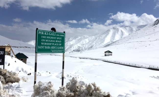
Unseasonal Snowfall Brings Winter in October in Parts of Kashmir

ARTICLESRINAGAR:  Even though it's the middle of autumn, in parts of Kashmir it seems like winter. Cold temperatures have brought unseasonal snowfall at higher reaches of the valley.
     For last two days Mughal Road that connects Kashmir valley with Pirpanjal region has remained closed and hundreds of trucks were stranded along the key passage.
    At an altitude of 11,000 feet, Peer Ki Gali, the highest spot on Mughal Road has seen about two feet of snowfall in last 48 hours. But as the weather improved today and sun came out, officials increased their efforts to clear the road.
    "Snow clearance machines are at work since yesterday and road will be fully functional today. We have already cleared over 500 trucks yesterday evening," said Nisar Ahmad, an engineer at Mughal Road.
SUMMARY: An area of India, Kashmir, is getting winter conditions very early in the year. There was a lot of snowfall. The article does not state why, but based off of what we recently learned in class some warm winds must be fueling the snow, or perhaps there is a lake nearby giving off lake-effect snow. To be quite honest, I didn't even realize it snowed in India except for mountaintops. I was always under the impression it was very hot there, all over.

LINK: http://www.ndtv.com/india-news/unseasonal-snowfall-brings-winter-in-october-in-parts-of-kashmir-1234573

"Ozone Pollution in Delhi Crosses Permissible Limit Again: India Weather Department"

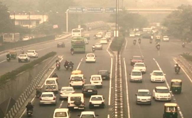
 Ozone Pollution in Delhi Crosses Permissible Limit Again: Weather Department

ARTICLENEW DELHI:  Surface ozone pollution in Delhi has crossed the permissible limit, for the second time in a year, with experts blaming weak monsoon for the phenomenon.
    Though the ozone layer limit in Mumbai and Pune has been in the permissible limits for the past two weeks, it is increasing in these two cities.
    According to scientists at the Indian Meteorological Department (IMD) and the Indian Institute of Tropical Meteorology (IITM), Delhi's surface ozone pollution usually crosses threshold level only during summer under scorching temperature around May-June.
    However, it is second time in this year that level of toxic ozone crossed the permissible limit in several locations in Delhi.
   "Surface ozone is always toxic. It's troublesome for asthmatic patients and those suffering from respiratory diseases.
    "Calm wind and humidity provide an ideal condition to produce toxic ozone," said Sunil Peshin, head of the EMRC (Environmental Monitoring Cell), IMD, Delhi.
In few areas like Lodhi road and Ayanagar, surface ozone (8 sunlit hour average) recorded by the IMD touched 100 ppb (part per billion) which is classified as 'poor' in air quality index scale.

    The permissible limit is 50 ppb (8 hour day average) as per the monitoring carried out under SAFAR (System of Air quality and weather Forecasting and Research) system of Ministry of Earth Sciences.
    "There is huge variability from one location to another within Delhi among 10 SAFAR stations due to emissions of NO2 mainly generated from fossil fuel burning. Due to high emissions from transport near traffic junctions, NOx level goes extremely high (above 15ppb) which then start helping in reducing ozone," said Gufran Beig, Project Director, SAFAR at IITM, Pune.
    In heavy traffic locations like Mathura road, Delhi University, Noida, although ozone remained in permissible level due to high NOx (mono-nitrogen oxide), but the particulate pollution of PM2.5 and PM10 remains high.

SUMMARY: This article speaks on the air pollution in India, New Delhi to be exact. Experts blame their lack of wind and humidity on the extra ozone pollution in the envrionment, as well as the recent lack of monsoons and other storms. The pollution is likely to affect the health of those with asthma and other breathing issues. Ozone pollution is very toxic.

LINK: http://www.ndtv.com/delhi-news/ozone-pollution-in-delhi-crosses-permissible-limit-again-1229907

Tuesday, October 20, 2015

"Record June Rain in Midwest Reduces Yield of Pumpkin Crop"


ARTICLE: Pumpkin pies may be in jeopardy this season due to heavy rainfall in parts of the Midwest over the summer.
     Many farmers are experiencing a smaller-than-normal pumpkin yield, especially of processing pumpkins, the variety used for making pumpkin pie and other seasonal foods.
     Large canned pumpkin manufacturer Libby told the Associated Press that yields could be off as much as a third this year in Illinois, the leading state in pumpkin production.
     Illinois had record rainfall during the month of June with most of the state receiving between 8 and 10 inches of rain or two to three times above the normal for the month of June.
     "The jet stream got stuck in a pattern over Illinois, bringing persistent storms with frequent and heavy rainfall throughout June," AccuWeather Senior Meteorologist Dale Mohler said.
     Mohler added that the region had little time to dry out because of the frequent rounds of wet weather.

SUMMARY: Apparently, there isn't likely to be many pumpkins this season! Because of plentiful summer rain, the pumpkin yield went down. This is because a jet stream got stuck over an area in Illinois, bringing a little too much rain in. Because of this, the ground and soil did not have enough time to dry and so it resulted in farmers growing smaller amounts of pumpkin.

LINK: http://www.accuweather.com/en/weather-news/midwest-rain-reduces-pumpkin-crop-yields-canned/53001898

"Chicago: Spotty Showers to Precede Late-Week Cooldown"


Image result for chicago 

ARTICLE:  Warm, unsettled weather will hold over the Chicago area through Wednesday before dry, cool conditions move in late in the week.
     Temperatures are forecast to reach the 70s F each day through Wednesday, noticeably warmer than the normal high of 61 F.
     However, people looking to head outside to enjoy the warmer-than-normal weather should keep an eye on the weather radar and AccuWeather MinuteCast® as each day will bring the risk for spotty showers.
     Baseball fans heading out to the ballpark to watch the Cubs host the Mets on Tuesday night and      Wednesday night might want to take a raincoat or poncho with them incase a shower moves through during the game.
     Even if a shower does move through during one of these games, they are likely to be brief and bring very little rain, meaning that they should cause minimal disruptions to the playoff games.

 SUMMARY: Due to warm temperatures and weather forecasting, it looks like Chicago will be getting random bouts of rain in the upcoming days. If they do appear, they shouldn't last too long. The article focuses on how this rain would affect the Cubs games, which they ended up losing. Shame. The author of the article was doubtful that rain would interfere with the game even if it did appear.

LINK: http://www.accuweather.com/en/weather-news/chicago-spotty-showers-to-prec/53083712

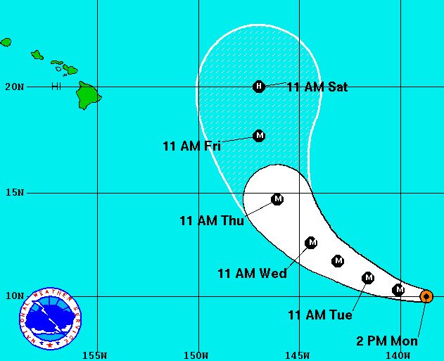
"Powerful Hurricane Olaf to Stir Up Surf in Hawaii"


ARTICLE: Hurricane Olaf will remain a powerful hurricane over the next several days, bringing high surf to Hawaii later this week.
     The potent storm is currently moving towards the west-northwest in the direction of the Hawaiian Islands, but is expected to turn to the north by the end of the week.
     This northerly turn should keep the storm several hundred miles to the east of the islands as it passes by on Friday into Saturday.
     Even though the storm will remain far enough away to keep rain and wind well offshore, high surf will be a threat to the Islands from Thursday into the weekend.
     "Olaf is a large and powerful hurricane," said AccuWeather Meteorologist Evan Duffey. "The large wind field around it is significantly disrupting the oceans surface."
    Swells will likely top 10 to 15 feet by the end of the week and this weekend.
    "The seas on the eastern shores of the Big Island could become especially rough," Duffey said.
    While surfers will delight in the higher swells, the high surf will be dangerous to beachgoers due to the large breaking waves and the threat of rip currents.

 SUMMARY: Surf's up, it turns out Hurricane Olaf will be making waves near Hawaii, a haven for the surfers of America. The storm neared the islands but didn't touch them. Since it is a Category 4 hurricane it will be making ripples by disrupting the ocean's surface. Waves over 10 feet are to be expected at the end of the week and though this is dangerous to beach enjoyers, surfers are looking forward for the weekend.

LINK: http://www.accuweather.com/en/weather-news/powerful-hurricane-olaf-to-sti/53094561

"400-Year-Old Church Emerges From Drying Mexico Reservoir"


ARTICLE: Amid building drought conditions, plummeting water levels in Mexico's Nezahualcoyotl reservoir have revealed a 400-year-old church known as the Temple of Santiago.
    The reservoir's water depth has dropped by 82 feet, according to the Associated Press, marking only the second time the church has been revealed since the dam was completed in 1966.
     Architect Carlos Navarete, who worked with Mexican authorities on a report about the church, told the Associated Press that the structure was built by a group of monks who arrived in the region inhabited by the Zoque people in the mid-16th century.
     It was then abandoned due to the plagues of 1773-1776, he said.
     "El Niño is likely the cause of the drought in this area," according to AccuWeather Meteorologist Rob Miller.
     El Niño causes strong wind shear in the atmosphere over Mexico, Central America and the  Caribbean, causing fewer tropical systems to develop.

SUMMARY: This article involves a subject I thoroughly enjoy, history, with weather! This article is all about how El Nino and changing climate conditions have contributed to the rediscovery of an old Mexican church. It was in a reservoir that hap been drying up since the 60's. Despite all the bad that human-induced climate change has and will bring, it will help shine a light on the farther reaches of human history that the oceans and lands have swallowed up.

LINK: http://www.accuweather.com/en/weather-news/photos-drought-uncovers-16th--century-mexico-church-reservoir/53080721

"Koppu to Lash Philippines Through Midweek Before Targeting Taiwan"


ARTICLE: Tropical Storm Koppu, also known as Lando, has killed at least 12 people in the Philippines according to the National Disaster Risk Reduction and Management Council of the Philippines. Even in a weakened state, Koppu will continue to bring life-threatening flooding to the northern Philippines through at least Wednesday.
     Koppu developed into a typhoon early Friday morning local time and strengthened through the end of the week, reaching super typhoon status late Saturday evening. With wind gusts up to 241 km/h (150 mph), the cyclone's intensity was similar to that of a strong Category 4 hurricane in the Atlantic Ocean.
     Very early Sunday morning, Koppu made landfall near Casiguran, Aurora, on the eastern coastline of Luzon with the intensity of a Category 4 hurricane.

SUMMARY: Tropical storm Koppu is causing destruction in the Phillipines and this article reports on that. Over 10 people are killed because of it and "life threatening flooding" entered the equation soon after. It is a category 4 and will likely cause further damage. The Philippines, despite their experience with tropical storms were taken of guard by the ferocity of this one.


LINK: http://www.accuweather.com/en/weather-news/tropical-storm-koppu-to-streng/52977291

"Olaf Strengthens to Category 4 Hurricane"

UPDATE: Olaf Strengthens to Category 4 Hurricane

ARTICLE: As of 11 a.m. the National Hurricane Center reports that Hurricane Olaf has reached category 4 hurricane status with maximum sustained winds near 130 mile per hour.
     Additional strengthening is forecast Monday night with fluctuations in strength expected over the next couple of days.
     The system is moving west near 12 mph with a turn to the west-northwest expected Tuesday followed by a jog to the northwest on Wednesday.
     On its current track, Hurricane Olaf is not expected to get close enough to affect the state.     However, as with all tropical systems, these forecasts have a high degree of uncertainty and Big Island Now will continue to monitor the storms progress and any changes that may occur.
     Hurricane-force winds extend outward up to 30 miles from the center and tropical-storm-force winds extend outward up to 140 miles.

SUMMARY: This article speaks on Hurricane Olaf's progress. Currently, it is a category 4 hurricane which means that it is one level away from the strongest a hurricane can be, with winds that can reach over 150 mph. It is still over the ocean and weather trackers suspect it will not reach land anytime soon.


LINK: https://bigislandnow.com/2015/10/19/olaf-strengthens-to-major-hurricane-status/

"Tropical Downpours to Stream Into Texas; Gulf of Mexico System May Develop"


ARTICLE: Regardless of tropical development in the western Gulf of Mexico or not, a stream of tropical moisture into Texas will raise the risk of heavy rain and flooding starting later this week.
     Although the Atlantic has been quiet since Hurricane Joaquin, conditions in the Gulf of Mexico are showing signs that the tropical season may not be finished.
     In years of strong El Niño, it is rather difficult for tropical systems to strengthen in the Atlantic due to unrelenting wind shear; this has been the cause for less-than-normal activity during the 2015 Atlantic hurricane season.
     Wind shear is a rapid change in direction and speed of air flow at different levels of the atmosphere. Wind shear can prevent a tropical system from forming and cause an organized tropical system to weaken.
     Without a parade of storms throughout the season to churn up and cool surface waters, the Gulf of Mexico has become very warm, leading to the enhancement of an area of unsettled weather later this week.

SUMMARY: This article speaks on how weather trackers have been able to see a pattern of movement of moisture into Texas. This warm moisture will likely fuel storms and rain in Texas. Flooding is also possible. However with the amount of moisture might be intefered with due to wind shear. Wind shear might be able to prevent the moisture from devloping too much in Texas


LINK: http://www.accuweather.com/en/weather-news/potential-tropical-development-1/53052102

"Additional Rainfall to Add to Historic Flooding Across Carolinas Into Monday"


ARTICLE: An intense band of heavy rainfall will continue across South Carolina and far southeastern North Carolina through Monday, worsening the already historic flooding that is underway.
In eastern South Carolina and southeastern North Carolina, totals will range from 12 to 24 inches, nearly half of the normal rainfall for an entire year in some areas.
"With records being broken for both rainfall and creek levels, it is easy to see why flood waters are inundating so many roads and communities," stated AccuWeather Senior Meteorologist Kristina Pydynowski, "and unfortunately, more rain will only worsen the life-threatening situation into Monday."

SUMMARY: This article covers how rain has been flooding North and South Carolina, enough so that the water depths are making the record books. There has been quite a bit of damage but nothing life threatening yet, though that could change. Rainfall rates could reach from 1-2 inches per hour, but it isn't certain yet.


LINK: http://www.accuweather.com/en/weather-news/tropical-storm-joaquin-east-coast-track-heavy-rain-deluge-flash-flooding-atlantic/52672710

Thursday, September 10, 2015

"Emergency Flood and Landslide Warnings in Japan; Levee Breach Destroys Homes, Forces Dramatic Rescues"


ARTICLE: "Dramatic helicopter rescues unfolded on live television in Japan Thursday as a flood-swollen river breached a levee, sending raging floodwaters into a neighborhood north of Tokyo and leaving dozens of residents trapped on the roofs or upper floors of their homes. At least 10 people are missing due to flooding and landslides caused by extreme rainfall resulting from former Tropical Storm Etau, and government officials have recommended new evacuations for more than 200,000 people as the heaviest rains shift farther north.

Rare emergency warnings for heavy rainfall, flooding and landslides were issued for nearly 5 million people in two prefectures near Tokyo Thursday morning as torrential rain continued to inundate parts of Japan, flooding hundreds of homes.
Just after midnight early Thursday (Japan time), the Japan Meteorological Agency issued an emergency warning for heavy rainfall in Tochigi Prefecture, north of Tokyo, where more than 20 inches of rain fell in 24 hours in some locations. (Japan is 13 hours ahead of U.S. Eastern Daylight Time.)

Shortly before 8 a.m. local time Thursday, JMA added nearly all of Ibaraki Prefecture, northeast of Tokyo, to the emergency heavy rainfall warning as the heavy rain band shifted ever so slightly to the east and rivers burst their banks as runoff from rain elsewhere drained into rivers flowing through the prefecture."

SUMMARY: This article only reinforces the usefulness and power of good, strong levies. In Japan recently, a levee either broke down or was overencumbered. This led to huge amounts of floodwater draining out into the rest of the nearby neighborhood, which trapped many people and led to several rescues. It appears that the rescues were hasty enough to keep fatalities low.

LINK: http://www.wunderground.com/news/tropical-storm-etau-japan-flooding-landslides

"Extreme Weather Barrages Southern California, Leaving at Least 1 Dead"

ARTICLE: "A bout of extreme weather is barraging Southern California with heat, hail and flooding, which has killed one and stranded several motorists.

Brett Alan Usher, 25, died Tuesday in Forest Falls, California, after he was swept away by floodwaters during a first date, KTLA-TV reported. The couple was trying cross a swollen river when they were pulled under. His body was later recovered by authorities.

The woman was reunited with her family after she was discovered by hikers, NBC News reported.

"It is scary," hiker Carlos Rojas told NBC News. "We just found her in a state of shock. She was screaming for help."

Raging floodwaters stranded multiple motorists in Southern California, and San Bernardino County firefighters conducted a swift-water rescue Tuesday night, according to the Victor Valley Daily Press.

“Moisture from Tropical Storm Linda is reaching north into portions of Southern California. The amount of moisture in the atmosphere is considerably above average and will help promote drenching thunderstorms across the area through the end of the week,” said weather.com meteorologist Quincy Vagell.

SUMMARY: The article speaks on freak weather that has been injuring and halting Souther Californians. Experts think that the moisture from Linda has been causing this and will continue to promote large storms in the aread.

LINK: http://www.wunderground.com/news/southern-california-extreme-weather-impacts

"Linda Weakening Quickly; Still Channeling Moisture Into the Desert"


  ARTICLE: "Linda continues to weaken as a tropical storm and should become a remnant low by late Thursday or Friday.

Linda will continue to track northwest, remaining well west of Mexico's Baja peninsula.

Linda has triggered a surge of moisture into the U.S. Desert Southwest, leading to enhanced coverage of rain and thunderstorms, there. This includes parts of southern Arizona and Southern California."

SUMMARY: Hurricane Linda has been weakening but it's sending lots of moisture out into American deserts. Whether this moisture will spread farther and fuel tornadoes in Tornado Alley cannot be foretold at this time.

LINK: http://www.wunderground.com/news/tropical-depression-fifteen-e-tropical-storm-hurricane-linda-eastern-pacific