http://www.weather.com/storms/severe/news/flood-threat-texas-louisiana-mississippi-valley-november-2015
Tuesday into early Wednesday morning, localized flooding was reported in Mississippi, Arkansas, southern Missouri, northwest Louisiana and eastern Texas, resulting in several road closures in those areas. Flash flooding moved into parts of Georgia by Wednesday afternoon.
The most numerous flood reports were in southern Missouri Tuesday where more than 5 inches of rain has fallen in some locations. A storm total of 6.85 inches was measured in Pershing, Missouri.
Some patchy flash flooding was reported around the Atlanta metropolitan area on Wednesday.
The widespread area of heavy rain is from the same area of low pressure aloft that has brought severe weather to the Plains and South, and a blizzard to the High Plains. Ahead of this low, a plume of deep, tropical moisture is being tapped not just from the Gulf of Mexico, but also from the western Caribbean Sea and eastern Pacific Ocean south of southern Mexico's Coast.
Showing posts with label Michelle Millan. Show all posts
Showing posts with label Michelle Millan. Show all posts
Sunday, December 6, 2015
Argentina Hailstorm Damages Homes, Vehicles; Flooding Rains Swamp Southern Brazil
http://www.weather.com/storms/severe/news/argentina-hailstorm-tornado-brazil-flooding-nov2015

Severe thunderstorms tore through parts of northern Argentina and southern Brazil Wednesday into early Thursday, dumping damaging hail, flooding rain, even spawning a tornado.
Hail up to the size of tennis balls pelted parts of Córdoba and Santa Fe provinces, west and northwest of the Argentine capital of Buenos Aires on Wednesday.
Storm Desmond Hits the U.K

Storm Desmond, the fourth named storm of the season, soaked parts of England, Scotland, Northern Ireland and Ireland over the weekend, bringing flooding rain, storm surge flooding and winds gusting over 100 mph.
Police in north London were investigating the death of a man who they believe was caught in a gust of wind and blown off a footpath into the side of a moving bus near Finchley Central Station, reports The Guardian. The 90-year-old was pronounced dead at the scene.
In Scotland, a jack-knifed FedEx truck crashed into the central reservation on the M8 at Bathgate, West Lothian, reports STV News. Lanes in both directions were closed.
Efforts to rescue a horse stranded in a flooded field in Ovingham, Northumberland, had to be canceled, according to the Chronicle. Firefighters were unsuccessful in reaching the horse, which was in floodwaters up to its middle. A man who attempted to save the horse himself became stuck and had to be rescued by a crew with the use of an inflatable boat.
Travel was disrupted in Ireland as numerous ferry sailings and flights were canceled, diverted or delayed by Desmond, reports The Irish Times. Dozens of departing and arriving flights to Dublin Airport were canceled Saturday. Rail travel also experienced delays of ten minutes.
Additionally, rescue crews were dispatched to 31 different flooding incidents involving people stranded in cars due to flood waters, reports the Belfast Telegraph.

when rocks fall, so can the temperature
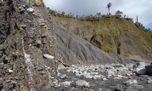
Climate change hit the headlines again last week during the Paris climate summit. The speed at which we have burned fossil fuels and increased the proportion of greenhouse gases in Earth’s atmosphere is staggering. But we are far from the first to wreak climate havoc on our planet.
A mind boggling 2800 million years ago photosynthesising bacteria began to flourish, using sunlight to convert carbon dioxide and water into food, and producing oxygen as waste. Their success rebalanced Earth’s atmosphere, increasing oxygen and reducing greenhouse gases. The result was one of Earth’s most severe ice ages – the Huronian glaciation – which lasted 300 million years.
Leaping forward to 470 million years ago, the first moss-like plants crept onto land. The acids they secreted dissolved the rocks they clung onto, and this weathering sucked carbon dioxide out of the atmosphere, triggering yet another ice age and a mass extinction. Roll on to 375 million years ago, and the same thing happened again – this time when rooted plants marched onto land and increased rock weathering.
Weathering of rocks can have ferocious climate consequences – it has tipped Earth into ice ages many times in the past, including the infamous “Snowball Earth” around 700 million years ago. So could rock weathering be our climate salvation today? According to a paper published last week in Nature Geoscience, landslides significantly accelerate weathering, because of the amount of fresh rock surface that they expose. But even so, we’d need a helluva lot of landslips to get us out of our current climate fix.
http://www.theguardian.com/science/2015/dec/06/rockfall-photosynthesis-climate-change-ice-age
Friday, December 4, 2015
9 States Still in Severe Drought
http://www.weather.com/climate-weather/drought/news/severe-drought-states


1. California: 93.91 percent of the state in severe drought or worse
In this image taken May 25, 2015, houseboats are moored on a shrinking arm of the Oroville Lake reservoir, which is now at 25 percent capacity.(MARK RALSTON/AFP/Getty Images)
The situation continues to grow more dire across the Golden State, where nearly all of the land is classified under severe drought or worse.
2. Nevada: 86.99 percent
Wind kicks up dust along the shores of Lake Mead at Boulder Beach on May 13, 2015 in Lake Mead National Recreation Area, Nevada.(Justin Sullivan/Getty Images)
Every weekly drought monitor release since the start of 2014 has listed all of Nevada under at least one of its five categories. Recently, most of the state has been in one of the three worst categories.
3. Oregon: 68.48 percent
Emigrant Lake is seen at extremely low levels in this image taken on Oct. 12, 2014. (flickr/Al Case)
Oregon continues to move in the wrong direction, and the current percentage of severe drought or worse is the state's highest in more than 15 months.
4. Utah: 34.38 percent
A view of a dried waterway off of Lake Powell at Lone Rock Camp on March 29, 2015 near Big Water, Utah. (Justin Sullivan/Getty Images)
Utah's severe drought has declined recently, down from 53 percent in mid-April.
5. Arizona: 29.26 percent
Low water levels are visible at Wahweap Marina at Lake Powell on March 29, 2015 in Page, Arizona. (Justin Sullivan/Getty Images)
Arizona has held mostly steady in recent months, but was able to rid itself of the second-worst drought category, "extreme." Most of the state remains in a serious drought, however.
6. Idaho: 26.19 percent
Pictured is an area near Bellevue, Idaho. (flickr/thomashawk)
For the first time since February 2014, the entire state of Idaho is under one of the five drought monitor levels. This is the second week in a row that at least one-fourth of the state is in severe drought.
7. Washington: 23.76 percent
Turnbull National Wildlife Refuge in Spokane County, Washington, is pictured in this image taken on Oct. 27, 2014. (flickr/Jason Hollinger)
The worst three drought categories now cover the largest percentage of the Evergreen State since March 2014.
8. New Mexico: 11.95 percent
Areas in northern New Mexico have seen the worst drought effects lately. (flickr/Chris Harrelson)
One year ago, nearly 85 percent of the state was in the three worst drought categories, so big strides have been made, but severe drought remains in northwestern New Mexico.
9. South Dakota: 1.32 percent
(flickr/Doug Letterman)
A small sliver of severe drought remains in eastern South Dakota, but nearly all of the worst drought categories have been eliminated in the last month. On May 5, 26 percent of the state was in severe drought or worse.
Lightning Damage
http://www.weather.com/storms/severe/news/lightning-damage-trees-homes-buildings-ground-20130719#/1


8.6 Million. That's how many times, on average, lightning strikes the Earth every day. That's about 100 times each second.
According to a 2004 study by lightning researchers, Dr. E. Phillip Krider and Kenneth Kehoe, the U.S. alone is hit about 30 million times each year by lightning.
With temperatures up to four times as hot as the sun (up to 50,000 degrees Fahrenheit), concentrated into a channel often as slender as a pencil, it's no wonder lightning can be destructive and deadly.
Lightning, Thunderstorms, Hail, Extreme Heat Hit Southern California
http://ktla.com/2015/09/09/lightning-thunderstorms-hail-extreme-heat-hit-southern-california-more-wild-weather-forecast-2/
An excessive heat warning was in effect in Los Angeles and Ventura counties, as soaring triple-digit temperatures were once again predicted in the valley areas and at lower elevations in the mountains, according to the National Weather Service.
The warning was scheduled to expire Thursday evening, with slightly cooler temperatures forecast for Friday and Saturday.
Triple-digit highs were also expected in the valley areas of San Bernardino and Riverside counties, prompting the weather service to issue a heat advisory for the region.
Meanwhile, monsoonal moisture was expected to bring more thunderstorms to the mountain and desert areas on Wednesday afternoon, according to forecasters.
The storms were capable of producing locally heavy rainfall and flash flooding, along with mud and debris flows in recent wildfire burn areas, the weather service stated.
As a result, a flash-flood watch that was issued on Tuesday remained in effect on Wednesday and was expected to last through Thursday evening. The affected areas included the valley and mountain areas of Riverside and San Bernardino counties, and the Apple, Lucerne and Coachella valleys.
Heat Wave in India
http://www.telegraph.co.uk/news/worldnews/asia/india/11636124/Indias-extreme-heat-wave-in-pictures.html
The link is a slideshow of pictures pertaining to the heat waves in India.
The link is a slideshow of pictures pertaining to the heat waves in India.
Heat and Drought
http://www.theguardian.com/environment/climate-consensus-97-per-cent/2015/sep/17/global-warmings-one-two-punch-extreme-heat-and-drought

As humans emit greenhouse gases into the environment, it causes the Earth to warm, we already know that. What is less certain is how it will cause changes to the weather we experience in our lives. In the past few years, research looking into the connection between a warming planet and more extreme weather has found more conclusive connections.
The authors present results of various heat wave severity (85%, 90%, and 95% events) and for various durations (3 day, 5 day, and 7 day events). Focusing on 1960-2010, they found that the concurrence of all combinations of drought, heat wave intensity, and heat wave durations “have increased substantially in the south, southeast, and parts of the western USA.”
Extreme Heat
At least 21 people have died and 66 more have been hospitalized as a major heat wave engulfs Egypt and much of the rest of the Middle East.
High humidity levels and temperatures as high as 116.6°F made conditions deadly for Egyptians in Cairo, Marsa Matruh province, and Qena province. All of those who died were over 60, according to Al Jazeera — an age group that’s among the most vulnerable to heat waves.
“There is a big rise in temperature compared with previous years. But the problem is the humidity which is affecting people more,” health ministry spokesman Hossam Abdel Ghaffar told Al Jazeera. “Long exposure under the sun is a killer.”
Egypt isn’t the only country suffering from extreme heat in recent weeks. Last month, higher than average temperatures also hit Turkey, and 100 people who tried to escape the heat by swimming in pools and lakes ended up drowning.
In Basra, Iraq, temperatures this week are supposed to stay steady around 123°F, the Guardianreports. Temperatures in the country are so high that on Thursday, the Iraqi government implemented a four-day holiday so that residents wouldn’t have to go to work in the heat. Last week, Iraqi citizens protested power outages that have made dealing with the extreme heat more difficult — in some regions, the BBC reports, it’s common to only have power for a few hours each day.
http://thinkprogress.org/climate/2015/08/10/3689813/heat-wave-middle-east/
Sunday, November 29, 2015
Winter Storm Ajax, the First Named Winter Storm of the Season, Brings Blizzard Conditions to High Plains
Ajax Snow, Wind Reports
Here are storm total snowfall reports from Ajax. The map below shows the estimated snowfall totals from Ajax in the areas that were affected.
California: Kingvale (10 inches); Mammoth Mountain Ski Area (8-12 inches); Kirkwood Ski Resort (14 inches); Squaw Valley Ski Resort (11 inches)
Nevada: Near Lamoille (21.7 inches at 9200 feet elevation); near McGill, Nevada (15 inches); Jiggs (12 inches)
Arizona: North-northwest of Flagstaff (11 inches)
Utah: Alta (15 inches); Mount Pleasant (10 inches); Fairview (10 inches); Park City (7.6 inches)
Colorado: Monument (30 inches with 3-4 foot drifts); Red Mountain Pass (28 inches); Telluride (12 inches); Near Aurora (up to 10 inches); Denver Int'l Airport (4 inches)
New Mexico: Ski Santa Fe (29 inches); Red River Ski (15 inches); Taos (9 inches); Albuquerque heights/northeast metro (up to 7 inches)
Wyoming: One observer northeast of Cheyenne reported 4 inches; officially, Cheyenne came in with 2 inches.
Nebraska: McCook (6 inches); Cambridge (3 inches)
Kansas: Colby (20 inches), Atwood (19.5 inches)
Texas: Texline (4 inches)
Oklahoma: Boise City (6 inches)

Ajax Snowfall Reports
The contour shows estimated snowfall amounts from Ajax Nov. 15-18, 2015. Plotted values are actual snow totals from National Weather Service reports.
Here are some peak wind gusts reported during Winter Storm Ajax in Colorado, Wyoming, New Mexico, Kansas and Nebraska.
- La Junta, Colorado: 70 mph (trees reported down)
- Cheyenne Mountain, Colorado: 68 mph
- Clines Corners, New Mexico: 64 mph
- Pueblo, Colorado: 64 mph
- Raton, New Mexico: 64 mph
- Tribune, Kansas: 63 mph
- Lamar, Colorado: 63 mph
- Limon, Colorado: 61 mph
- Denver International Airport: 58 mph
- McCook, Nebraska: 56 mph
Classic November Storm Brings Blizzard Conditions to the High Plains; Snow to the West
http://www.weather.com/forecast/regional/news/snow-mountain-west-high-plains-nov2015

Farther east on the plains of northeast Colorado, a storm spotter located about 8 miles southeast of Watkins reported blizzard conditions Wednesday morning with winds gusting to 47 mph, reducing visibility to less than a quarter mile. Another local storm report from the National Weather Service said that blizzard conditions were observed near Grant, Nebraska, late Wednesday morning.
Thundersnow was also reported in the Plains of eastern Colorado and western Nebraska Wednesday morning and afternoon.
The snow and wind forced the closure of I-80 in Wyoming Wednesday from near Cheyenne to near Rock Springs, the Wyoming DOT reported. Portions of I-70 were closed west of Denver at times Wednesday morning, and the Colorado DOT said that all vehicles must have snow tires, four-wheel drive or chains between Vail and Georgetown. A rockslide was reported on the eastbound lanes of I-70 near Glenwood Canyon, temporarily closing those lanes.
Snow and wind also affected Interstate 25 between Denver and Cheyenne early Wednesday morning, but conditions rapidly improved late morning as skies cleared and snow melted from the roadway.
Prior to bringing snow and strong winds to the High Plains, the same storm system dumped snow on many western states Monday into early Wednesday.
Up to 10 inches of snow was measured in parts of the Reno, Nevada, metro area as of late Monday night. At the National Weather Service office, 4 inches of snow fell in one hour Monday evening. Only 2.7 inches of snow fell all last season at the Reno-Tahoe International Airport, their second least snowy season on record. The official storm total in Reno was 4.2 inches.
In California's Sierra Nevada, 26-36 inches of snow was measured at Mammoth Ski Area.
Ely, Nevada, about 250 miles north of Las Vegas, set a record calendar-day November snowfall Monday, picking up 12.3 inches. This was the seventh heaviest calendar-day snow, there, dating to 1893, and their heaviest one-day snow event since April 7, 2011. The two-day storm total was 12.9 inches. Only 19.7 inches of snow fell, there, all last season.
In Utah, some of the heaviest snow fell in the Wasatch Mountains, where as much as 15 inches was reported at Snowbird. An estimated 30 inches of snow fell at the La Sal Mountain Snotel in eastern Utah.
Kate Weakens Over Open Waters of Atlantic
http://www.accuweather.com/en/weather-news/tropical-atlantic-hurricane-ba/53484183

Kate became the fourth tropical system to reach hurricane strength during the 2015 hurricane season after it strengthened early on Wednesday morning.
During its time as a hurricane, Kate left its mark in history by becoming the latest on record for a hurricane to form so far northwest in the Atlantic basin.
Watching the Atlantic for Possible Tropical Development Near the Bahamas
The Atlantic hurricane season is not over yet, and an area of low pressure dubbed Invest 94-L developed into Tropical Depression Twelve Sunday night.
Since Hurricane Joaquin dissipated just about a month ago, the tropics have been quiet in the North Atlantic. A persistent pattern characterized by record levels of wind shear has been a driving force in inhibiting tropical development this season.

November Tropical Clim
The Atlantic hurricane season officially comes to an end on Nov. 30. With the ocean cooling from north to south, particularly at the mid-latitudes, the formation zone for tropical systems shrinks.

Although the Gulf of Mexico stays relatively warm through much of the month, historically, as the jet stream shifts south, the environment tends to become increasingly hostile due to stronger wind shear.
In the period of record from 1851 to 2014, no tropical storm or hurricane has impacted the western Gulf Coast from Texas to Mississippi.
To the southeast, systems that do develop across the Caribbean can gain some organization, as the area has supported such late-season hurricanes as Kate in 1985 and Michelle in 2001. The former became the latest landfalling hurricane in Florida’s history on Nov. 21.
Otherwise, due to increasing upper level flow, any system that does develop tends to quickly turn north and northeast into the open Atlantic and away from the United States.
Since 1851, Florida has been impacted by eight tropical storms and hurricanes in November. The only other states with more than one impact were also in the Southeast: Alabama, Georgia and North Carolina.
http://www.weather.com/storms/hurricane/news/tropical-development-atlantic-nov-2015
2015 Atlantic Hurricane Season Forecast Issued By The Weather Channel
http://www.weather.com/storms/hurricane/news/hurricane-season-forecast-atlantic-weather-channel-cs
A new hurricane season forecast issued by The Weather Channel on Tuesday says we can expect the number of named storms and hurricanes in the 2015 Atlantic season to stay below historical averages.

A total of nine named storms, five hurricanes and one major hurricane are expected this season, according to the forecast prepared by The Weather Channel Professional Division. This is below the 30-year average of 12 named storms, six hurricanes and three major hurricanes. A major hurricane is one that is Category 3 or stronger on the Saffir-Simpson Hurricane Wind Scale.
Meteorologist Dr. Todd Crawford of The Weather Channel Professional Division says, “Both the dynamical models and our proprietary statistical models suggest a relatively quiet tropical season this year."
The Weather Channel forecast for below-average activity during the 2015 Atlantic hurricane season is consistent with what Colorado State University (CSU) said in its forecast issued on April 9. CSU's forecast called for seven named storms, including three hurricanes, one of which is predicted to attain major hurricane status.
The CSU outlook, headed by Dr. Phil Klotzbach in consultation with long-time hurricane expert Dr. William Gray, is based on a combination of 29 years of statistical predictors, combined with analog seasons exhibiting similar features of sea-level pressure and sea-surface temperatures in the Atlantic and eastern Pacific Oceans.
there are four questions about this outlook in the article.
Subscribe to:
Posts (Atom)