Showing posts with label Miranda Baldwin. Show all posts

Sunday, December 7, 2014

Temperature roller-coaster in the East, as snow and rain move in

A big dip on Tuesday is sandwiched between daytime highs above 10oC across the region on Monday and Wednesday.
As of 10 a.m. Tuesday, only St. John's was above zero, sitting at a mere 2oC, one degree shy of its expected daytime high.
In the Maritimes, major cities began the day well below zero, feeling colder with the wind. Halifax will struggle to crack -5oC, Fredericton may reach zero, and Charlottetown could make it to 2oC.
And on Wednesday, it's back up into positive territory, with many cities likely to reach the 10oC mark once again.
A warm front arrives into the Maritimes through the pre-dawn hours Wednesday, with a mixture of rain along the Nova Scotia coast line, but snow in central New Brunswick," Weather Network meteorologist Brian Dillon said Tuesday morning
Any snow that does fall likely won't stick around for long, as Thursday's forecast highs, while not as balmy, are still likely to be above zero.
 http://www.theweathernetwork.com/news/articles/temperature-roller-coaster-in-the-east-as-snow-and-rain-moves-in/41132/

Freezing drizzle advisories in effect for eastern Ontario

Weather advisories for freezing drizzle are issued when drizzle falling in sub-zero temperatures is expected to freeze on contact and over time create icy surfaces," Environment Canada says in a statement.
Friday has been a calm day with high pressure in place. The next system remains mostly stateside Friday night into Saturday morning -- although the latest forecast wants to push a snow/rain mix through southern Ontario," says Weather Network meteorologist Erin Wenckstern. Sarnia across to Toronto and communities hugging the shorelines of Lake Ontario could see mixing but if it does hit, it will be brief. 
  Residents of affected areas are being warned to take extra care when walking or driving Friday into Saturday.
 http://www.theweathernetwork.com/news/articles/freezing-drizzle-advisories-in-effect-for-eastern-ontario/41341/

California's drought is the worst in 1,200 years, evidence suggests

As soon as the National Oceanic and Atmospheric Administration (NOAA) released climate data for the summer of 2014, the two scientists sprang into action. Using their blue oak data, they reconstructed rainfall back to the 13th century. They also calculated the severity of the drought by combining NOAA's estimates of the Palmer Drought Severity Index (PDSI), an index of soil moisture variability, with the existing North American Drought Atlas, a spatial tree-ring based reconstruction of drought developed by scientists at Columbia University's Lamont-Doherty Earth Observatory. These resources together provided complementary data on rainfall and soil moisture over the past millennium. Griffin and Anchukaitis found that while the current period of low precipitation is not unusual in California's history, these rainfall deficits combined with sustained record high temperatures created the current multiyear severe water shortages. "While it is precipitation that sets the rhythm of California drought, temperature weighs in on the pitch," says Anchukaitis.
Tree rings are a valuable data source when tracking historical climate, weather and natural disaster trends. Floods, fires, drought and other elements that can affect growing conditions are reflected in the development of tree rings, and since each ring represents one year the samples collected from centuries-old trees are a virtual timeline that extend beyond the historical record in North America.
So what are the implications? The research indicates that natural climate system variability is compounded by human-caused climate change and that "hot" droughts such as the current one are likely to occur again in the future. California is the world's 8th largest economy and the source of a substantial amount of U.S. produce. Surface water supply shortages there have impacts well beyond the state's borders.
 http://www.sciencedaily.com/releases/2014/12/141205124357.htm

December Thaw: Long Warm Spell Likely for Much of Western, Central U.S. Through Mid-Month

A prolonged spell of unusually warm December weather is expected to cover a sizable swath of the U.S. in the week ahead, and even the occasional interruptions in the mild pattern won't be all that cold.
A jet stream pattern that has encouraged cold air masses from near the Arctic Circle to rush southward into the U.S. has changed, allowing much milder air from the Pacific Ocean and Gulf of Mexico to become the dominant influences on temperatures.
Computer forecast models are in strong agreement that this will allow unseasonably warm weather to take over a large part of the western and central U.S., not to mention a large swath of western and central Canada, for most of the upcoming week.
This means temperatures will stay well above freezing, day and night, across much of the Deep South this weekend through at least Tuesday.
Meanwhile, subzero lows and single-digit highs in the north-central states should give way to high temperatures at or above freezing at times, especially late in the week ahead.
 http://www.weather.com/forecast/national/news/december-thaw-major-warming-trend
 Outlook: Morning Lows This Weekend


Winter Weather Watch 2014-2015: Northeast Storm, More Sierra Snow

Computer model guidance continues to show uncertainties for the winter weather system that could produce a significant snow from the eastern Great Lakes through Interior New England Tuesday into Thursday. Cold air (to keep precipitation all snow) is at a premium with this storm, more like an early November or late March scenario. Cold air is normally not much of a problem in December!
East Coast cities will see rain. Interior cities in the Northeast at lower elevations (PA/NY/western New England) will see snow mixing with or changing to rain at times Tuesday to Wednesday. Rain/mix turn back to all snow by late Wednesday and continuing Wednesday night into Thursday but a big question is how much snow can fall after this occurs? This is a tricky situation with marginal cold air, some dynamics, exact track, slow movement. So, it won't be snowing continuously and heavier precipitation could come in intermittent "spurts". For cities in the interior Northeast snow will fall with temps in the low to mid 30s and could mix with rain at times (especially Tuesday) so getting around shouldn't be too difficult.
 The impacts from this system will occur in the early Tuesday through Thursday time frame.
 http://www.weather.com/storms/winter/news/winter-weather-watch-2014-2015-20140930
48-Hour Snowfall Forecast

Former Typhoon Hagupit (Ruby) Slowly Moves Through the Philippines; Dangerous Flood Threat Continues

Former Super Typhoon Hagupit was downgraded to a tropical storm Sunday evening U.S. time but continues to lash the Philippines with locally heavy rainfall.
Hagupit, known in the Philippines as Ruby, has made two landfalls in that country as a typhoon and continues to lash the central and northern portions of the country with heavy rainfall and blustery winds.
Just over 1 million people had been evacuated due to the storm as of Monday morning, local time, according to the Philippines National Disaster Risk Reduction and Management Council.
 In general, a tropical cyclone's rainfall potential depends on how slowly it moves, not its intensity. Hagupit will be moving along very slowly over an area with rugged terrain. As a result, rainfall totals could be extraordinarily high -- locally exceeding 18 inches -- leading to landslides, debris flows, and life-threatening flash floods.
 http://www.weather.com/storms/typhoon/news/typhoon-hagupit-ruby-philippines-landfall-impact
Hagupit: Infrared Satellite

Thursday, December 4, 2014

Study: Global Warming Happens Quicker Than Previously Thought

Global leaders currently meeting in Peru for the U.N. climate talks might have come to the summit with the assumption that, based on the current body of scientific research, the Earth wouldn't start warming from today's carbon emissions for 30 to 40 years.
But according to new research, the lag time between carbon emissions and their impact on the atmosphere might actually be much shorter, down to just 10 years, meaning that whatever policy leaders draft and vote on in Paris in 2015 could have a much more immediate impact on Earth's changing climate.
It's important to note that, while this study shortens the estimated time frame between carbon emissions and peak warming, it still reaffirms that CO2 can linger in the atmosphere for years, leading to warming that can persist for centuries, Phys.org reports.
That means any international agreement to curb carbon emissions could have a much more immediate impact on short term climate change effects like heat waves and other extreme weather events, but long term effects like sea level rise and glacial melt would still be felt for centuries to come due to current and past emissions.
 http://www.weather.com/science/environment/news/global-warming-study

2014 On Track for Hottest Year on Record, U.N. Weather Agency Says

The U.N. weather agency dismissed claims global warming has paused on Wednesday, after temperature data revealed 2014 was tied for hottest year on record.
In January-October of 2014, the global average temperature was 1.03 Fahrenheit above average, the World Meteorological Organization reported. The same record hot was recorded in 2010.
"Whether such a period is about to begin, we cannot say but the warm 2014 is a reminder that the warming never stopped and the long term trend is up, up, up," Oppenheimer said.
While scientists are now 95 percent certain that the temperature rise since the middle of the 20th century is mostly man-made, they can't say with the same confidence how the warming affects different parts of the climate system, including the frequency of tropical storms or hurricanes.
 U.N. climate chief Christiana Figueres said temperature data added urgency to the talks, but noted that you don't have to be a scientist to realize that the climate is changing.
 http://www.weather.com/science/environment/news/2014-hottest-year-record-un-weather-agency-global-warming

France Flooding: At Least Five Dead, Thousands Evacuated

Days of heavy rain in southern France triggered flash floods and severe river flooding, killing at least five people and forcing the evacuations of thousands.
"The culprit was a stuck upper-level low over the western Mediterranean Sea cutoff from the main jet stream," weather.com senior meteorologist Jonathan Erdman. "While this first low will weaken and slide east, another closed low aloft may form over the Iberian peninsula later this week, bringing more locally heavy rain to the south of France later this week."
Rain and flooding has plagued the south of France this year. In September and October, two major flash flooding events swept through Montpellier, France. The second event dumped more than 10 inches of rain, causing a torrent of floodwater to rush through the city and its soccer stadium, severely damaging the structure.
http://www.weather.com/news/news/france-severe-flooding
 

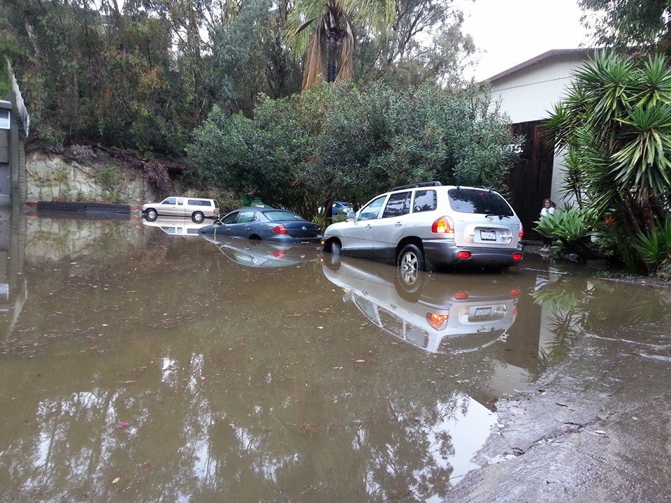
California Rainfall: Sinkholes, Mudslides Reported; Flooding Hits San Diego Area

The drought-parched state of California definitely needed a soaking rain event, but all this precipitation has also had negative consequences.
Mudslides, rockslides and sinkholes have all been reported following days of rainfall across the state, leaving some streets flooded and residents in wildfire-scarred areas reaching for sandbags. While much of the event is ending, some areas are still expected to see more rain before the system leaves California.
 Flooded streets were also observed in parts of San Mateo, San Francisco, Alameda and Santa Clara counties Tuesday morning, according to National Weather Service storm reports. Through Wednesday afternoon, San Francisco International Airport had reported 3.71 inches of rain since Sunday, which was more than the hub recorded in all of 2013. The airport received just 3.38 inches of rain last year, according to local records.
 http://www.weather.com/news/news/california-rainfall-flooding-latest-news
View image on Twitter

Typhoon Hagupit (Ruby): Potentially Life-Threatening Landfall Expected in Philippines

Typhoon Hagupit, a powerful tropical cyclone in the tropical western Pacific Ocean, is closing in on the Philippines and now appears almost certain to make landfall there this weekend. Preparations are underway for potentially life-threatening winds, storm surge and flash floods in the Philippines, where the typhoon has been named Ruby.
 The Japan Meteorological Agency (JMA) earlier declared Hagupit a "violent" typhoon, the highest classification on its scale, with 10-minute sustained winds of 130 mph and gusts to 190 mph. That ties Vongfong for the highest wind speeds of 2014 in JMA's bulletins. Hagupit has since been downgraded to a "very strong" typhoon on JMA's scale with winds of 115 mph and gusts to 160 mph as of 8 p.m. EST Thursday.
Again, there is some uncertainty in Hagupit's path and forward speed, but in general its center should move northwest in the general direction of Metro Manila. The process is expected to be agonizingly slow -- potentially taking 72 hours to move from the eastern Philippines to Metro Manila.
 http://www.weather.com/storms/typhoon/news/super-typhoon-hagupit-ruby-philippines-tacloban
Model Rainfall Forecast

Sunday, November 30, 2014

Hurricane-Force Winds Whip Cody, Wyoming, Knocking Out Power, Breaking Windows

The small town of Cody, Wyoming, was taken by surprise when hurricane-force winds whipped the area, causing power outages, uprooting a power pole and transformers and blowing out windows.

The wind gusts the area experienced were powerful, as weather.com meteorologist Linda Lam described, “Chinook winds developed along parts of the Front Range of the Rocky Mountains on Friday. This strong downslope wind brought wind gusts of over 80 mph to some locations. As the wind comes down the leeward side of the Rocky Mountains the dry air warms. The warm and gusty winds ahead of an approaching cold front resulted in some record and near-record warm temperatures as well."

The highest wind gust reported was 117 mph near Clark, Wyoming, and the high wind warnings continue into Sunday for parts of Wyoming and Colorado.

 http://www.weather.com/news/news/cody-wyoming-strong-winds-impacts

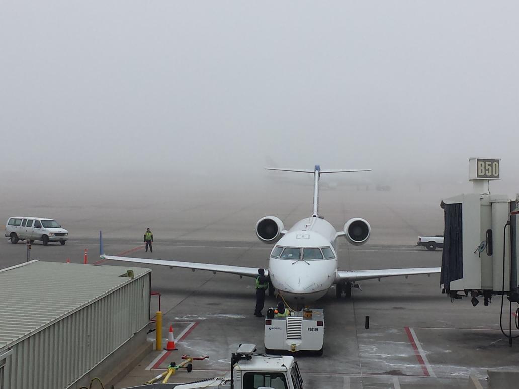
Denver International Airport Experiences Dozens of Delays Due to Freezing Fog

"An arctic cold front blasted southwestward into the Denver area Sunday morning," said weather.com senior digital meteorologist Nick Wiltgen. "The cold air was nearly saturated -- humidity was near 100 percent -- and the east-northeast winds bringing it into Denver were blowing upslope toward the Rockies."
 
Wiltgen added: "The combination of cold, moist air and a wind blowing upslope led to very low clouds and thick fog -- in this case, freezing fog, since temperatures quickly plunged well below freezing. The fog, the icing concerns, the strong winds -- all of these are just bad news for trying to get planes in an out of a busy airport."
 
Departures were delayed as well. Flightaware.com said that as of 2 p.m. Sunday, 22 percent of the roughly 1,000 flights originating from DIA Sunday had been delayed, a larger percentage than any other U.S. airport at that time.
 
Coale stated more than 166,000 passengers were expected to pass through DIA on Sunday, 26,000 more than usual, the Denver Post reported.  Monday is also expecting a large amount of passengers, at least 157,000. 
 http://www.weather.com/news/news/denver-international-airport-thanksgiving-weekend-delays-fog
 View image on Twitter

Big Welcome Storm Headed California’s Way

       The West Coast storm is expected to bring desperately needed rain and snow to parts of California. The state has been mired in a 3-year-long drought that has seen its driest year on record and what is almost certain to be its warmest year on record. Of course, one storm won’t erase such a deep moisture deficit, which has left some communities on the brink of waterlessness. But it’s at least a small step in the right direction, local forecasters and climate scientists say.
      There are indications that this storm could be the start of some wetter weather for California. The December outlook from the National Oceanic and Atmospheric Administration called for better chances of above-normal precipitation for the whole state, in part because of the El Niño struggling to fully develop in the Pacific Ocean.
      “They seem to think that this will continue at least for a little while,” Tom Dang, a meteorologist in the Sacramento NWS office, said. And if nothing else, it’s unlikely California will see a repeat of last winter: “It’s very difficult for it to reach the levels that we reached last winter,” Dang said. “We’re certainly on much better footing” this year than last year.
 http://www.weather.com/news/news/california-drought-rain-coming
 

Sunday, October 5, 2014

Lunar Eclipse Forecast: Will The Weather Cooperate?

Mark your calendars: The next lunar eclipse will take place during the early morning hours on Wednesday, October 8. The eclipse begins at 5:15 a.m. Eastern Time, which means a partial eclipse will be visible in the East and a fully visible eclipse will occur for the West Coast.

 Hands down, the West will have the best chance of viewing the lunar eclipse. In addition to being in the right astronomical placement for the entire eclipse to be visible, Mother Nature will also allow for wide-open skies, courtesy of high pressure that will dominate much of the West Coast and into the Rocky Mountains.

In the East, an approaching cold front will create some cloud cover for areas east of Birmingham, Alabama to Raleigh, North Carolina. Thicker clouds may impede skygazers' view of the eclipse, but any breaks in the clouds would be a welcomed sight for anyone hoping to catch a glimpse of the eclipse.

 Unfortunately for much of the Northeast and Great Lakes states, a low pressure system will generate rain showers and thick cloud cover during much of the overnight and early morning hours on October 8. A cold front associated with the low will drape south through the Appalachian states and into northern Georgia and central Alabama, effectively leaving the chance of catching the eclipse slim to none. Instead of braving the rain, it might be a better idea to watch the eclipse online.

 http://www.wunderground.com/news/lunar-eclipse-october-weather-forecast-20141003

October Chill Targets the East, Summer Returns in the West

Just in time for the first weekend in October, a plunge of chilly air is driving south and providing a crisp taste of fall in the Midwest and East. Meanwhile, the West coast has heated back up.

 Changes, however, are in the wind, and they will continue through the weekend. An upper-atmospheric trough is carving southward into the East and Midwest, while a corresponding upper-atmospheric ridge builds into the West (previously, we had had a ridge in the East and a trough in the West).

This pattern change has brought temperatures that are 20-30 degrees colder for some locations in the northern Plains. Temperatures will also be cooler in parts of the Midwest and Northeast, where highs are going from the 70s and 80s last weekend to the 50s and 60s, with a few locations in the Midwest even staying in the 40s, this weekend.

 Fall is definitely a season of change and this will be apparent to many as we head through early October.

http://www.wunderground.com/news/pattern-change-ahead-20140927

Global Warming Might Push Back Fall Foliage Transformations


According to a report by Princeton University researchers in Global Ecology and Biogeography, climate change might affect when fall foliage appears in different parts of North America.

 In the study, the researchers explained that trees need low daily temperatures and short daylight hours to churn out their famous autumnal shades.

During the study, Medvigy and Jeong found that fall foliage timing is more sensitive to temperature changes in warmer areas – meaning Alaska is unlikely to see changes in its fall foliage timing by the end of the century, but Massachusetts’ trees might change a month later than normal.

"We now have a much better understanding of how temperature, day-length and leaf color are related," Medvigy said. "This understanding will help us make better forecasts for climate, as well as for the basic dynamics of forests. My group is now investigating these issues together with researchers from GFDL."


Reading, Penn.http://www.weather.com/news/science/environment/global-warming-fall-leaves-20140922

35,000 Walrus Come Ashore in Alaska As Sea Ice Retreats

The images above show 35,000 Pacific walrus, all looking for a place to rest. They usually rest on Arctic ice. In these photos, they're all coming ashore in Alaska because there isn't any ice to be found.

As an early September study published in the journal Marine Mammal Science notes, walruses use floating sea ice as a place to rest between bouts of foraging for food in deeper ocean waters. When the sea ice isn't there -- the extent of Arctic sea ice has been declining rapidly for the past few decades, reaching an all-time recorded low in 2012 -- walruses are forced to forage for food closer to land.

 "We are witnessing a slow-motion catastrophe in the Arctic," Lou Leonard, vice president for climate change at the World Wildlife Fund, said in a statement that was reported by CNN. "As this ice dwindles, the Arctic will experience some of the most dramatic changes our generation has ever witnessed. This loss will impact the annual migration of wildlife through the region, threaten the long-term health of walrus and polar bear populations, and change the lives of those who rely on the Arctic ecosystem for their way of life."

Point Lay, Alaska http://www.weather.com/news/science/environment/alaska-walrus-photos-20141002

Aral Sea's Eastern Basin Has Gone Dry


 In a landmark moment that will go without celebration, the eastern basin of the South Aral Sea has completely dried for the first time in modern history.

"This is the first time the eastern basin has completely dried in modern times," Philip Micklin, a geographer emeritus from Western Michigan University and an Aral Sea expert, told NASA. "And it is likely the first time it has completely dried in 600 years, since Medieval desiccation associated with diversion of Amu Darya to the Caspian Sea."

What was once the world’s fourth-largest lake is now split into several pieces:  the Northern and Southern Aral Seas, and further, the eastern and western lobes of the larger Southern Aral Sea.

 The Aral Sea's Eastern Basin
http://www.weather.com/news/science/environment/aral-sea-eastern-lobe-20140927

Typhoon Phanfone

Tokyo is bracing for potentially unprecedented high winds as Typhoon Phanfone makes a beeline for the world's largest metropolitan area.

 The eye of Phanfone is now just south of Japan's Pacific coast and moving east-northeast on a track that is likely to take it directly over Tokyo between 9 a.m. and noon Monday local time (8 and 11 p.m. EDT Sunday in the U.S.).

 The typhoon's effects have already proven deadly. One U.S. airman has been found dead and two others are missing after waves caused by Typhoon Phanfone swept them away in Okinawa, according to a U.S. military official.

Phanfone Forecast Path/Intensity
http://www.weather.com/news/weather-hurricanes/typhoon-phanfone-heads-towards-japan-weekend-20141004