Showing posts with label Melanie Lindsay. Show all posts

Monday, November 10, 2014

Polarlocalypse 2014 and a Storm

A warm day is in store for the region on Tuesday ahead of our approaching cold front. Absolutely a good day to get out and enjoy the weather one last time or use it to stow away the summertime outdoor gear and prep your storm doors, windows, a/c units, garden hoses, little used patio furniture and the like for winter.


An active period of weather awaits us in the form of two cold snaps and a couple of weather systems. Many details are impossible to pinpoint with high confidence until we enter very close timing windows. The sampling of and thus the modeling of our polar jet stream and it's very important disturbances has been quite poor recently and this is going to continue. As such until we are within a minimum 72 hours and more favorably within 48 hours of an event while we may have sound theories to discuss we do not and will not have a confident solution you can plan for.

Unsettled weather will precede the passage of a cold front on Wednesday. As the cold air filters in a minor disturbance may affect the region with some light rain and possibly snow showers early Friday morning before slipping off the Mid-Atlantic coastline. Several disturbances may come together to produce a significant weather system on Monday that does feature a snow fall threat before it departs the region. A second strong cold snap is expected to invade the region following this potential storm system.

With such uncertainty regarding the evolution and timing of our polar jet stream I would caution that there's a decent chance a lot of what you read below will be changing. As it does we will evolve along with it and discuss the new possibilities within the blog comments section. All comments, ideas, and model map postings are welcome. We should have plenty to talk about!

http://www.wunderground.com/blog/Pcroton/comment.html?entrynum=64

November 25-29 Potentially Significant Winter Storm

The storm system around the November 25-29/Thanksgiving timeframe continues to look like a significant storm system.

OPC
On the morning of November 8th, we saw the remnants of Typhoon Nuri reach peak strength via Ocean Prediction Center observation. As the chart shows here, the massive storm bottomed out at 924 millibars. This means the storm, located at about 170E and 55N, didn't break the record for strongest extratropical cyclone on record, but it certainly came close.

NWS
The graphic above, produced by the National Weather Service in Alaska, shows the observed mean sea level pressure of the storm at that 924mb reading, while the NWS office measured it at 930mb on the chart on the left, where strongest extratropical cyclones in the North Pacific are depicted. For multiple reasons, including the possibility that past storms may have been stronger than that 924mb reading, this storm was not declared the strongest on record in the North Pacific. Despite this, it's quite clear this storm was a historically-strong one, relative to storms in the last 60 or so years.

NOAA
Purely for comparison purposes, the team at KOPN Weather identified a strong storm in the Bering Sea on April 7th, 2011, bottoming out at 936mb, that was about 10 degrees W of where this very strong storm was observed yesterday in the Bering Sea. If you recall what happened about 2-3 weeks after the date of April 7th, we saw a certain tornado outbreak strike the South US, devastating thousands across the country, and causing millions on millions of dollars of damage. If we look at where the resultant storm ended up in mid-late April, utilizing the Bering Sea Rule, we find the storm situated in the Ohio Valley.
- See more at: http://theweathercentre.blogspot.com/#sthash.gCHxESpl.dpuf

http://theweathercentre.blogspot.com/

Severe weather likely factor in Bahamas fatal plane crash

Severe weather was likely a factor in the small plane crash that killed nine people, including a prominent Christian minister and his wife, on approach to the island of Grand Bahama, the foreign minister said Monday.


Heavy rain was buffeting the region when the Lear 36 Executive Jet struck a shipping container crane in Freeport as it tried to land, Foreign Minister Fred Mitchell said.


Thank you for reading and relying on Omaha.com for your news and information. You have now viewed your 30 day allowance of 15 free articles.
If you have any questions or need further information please call 402-346-3363 or 1-800-234-6942 or email customer.service@owh.com.

Start your All-Access Package today!

An online service is needed to view this article in its entirety.

You must login to view the full content on this page.

Mitchell said that a commercial Bahamasair flight making the same route, from Nassau to Freeport, had turned back because it was unable to land around the same time as the flight carrying the Rev. Myles Munroe and several members of his Bahamas Faith Ministries.
Civil aviation authorities launched the investigation Monday.
The death of Munroe, one of the most prominent pastors in predominantly Christian Bahamas, stunned the country, Mitchell said.
"It is utterly impossible to measure the magnitude of Dr. Munroe's loss to the Bahamas and to the world," Prime Minister Perry Christie said. "He was indisputably one of the most globally recognizable religious figures our nation has ever produced."
Munroe, 60, and his entourage were traveling to Grand Bahama to attend the 2014 Global Leadership Forum that he organized. He planned to have dinner in Freeport about 90 minutes after his plane's scheduling landing with former United Nations Ambassador Andrew Young, a speaker at the event, Mitchell said.
Munroe's wife, Ruth, was also on the plane, along with the pastor considered second-in-command at Bahamas Faith Ministries, Richard Pinder, as well as the group's youth minister and his wife and child.
  
Munroe grew up poor in the Bahamas and built a ministry and educational organization modeled after his alma mater, Oral Roberts University, in Tulsa, Oklahoma. He went on to create a successful career as a spiritual adviser, motivational speaker and to run a leadership program that included the annual conference in Freeport.
"He has really put his name on the world stage and helped the Bahamas achieve recognition for talent," the foreign minister said.
 

Area to miss major snowstorm, but not the polar plunge

FEATURE11102014

Typhoons, Cyclones and Severe weather alert!

The big headline heading into  Columbus Day will be the severe weather outbreak that will begin overnight and last through Tuesday as a powerful storm emerges from the Rockies and makes its way across the Plains and Mississippi Valley.
Today’s threat of severe is across the Central and Southern Plains with  heavy rain, large hail and damaging winds.
Overnight tonight and into Monday and Tuesday from Texas through the Mississippi Valley, the Tennessee and Ohio Valleys and the Gulf Coast States strong to severe storms could threaten millions of people.  Along with hail, damaging winds and flooding rain we could have several tornadoes.
In the tropics, Tropical storm Faye pounded Bermuda as a strong tropical storm with 70 mph winds, heavy rain and battering surf overnight.  The storm is quickly moving Northeast away from land.


Rare Medicane Hits Malta and Sicily With Tropical Storm-Like Conditions

A rare "Medicane"--a hybrid storm with characteristics of both a tropical storm and an extratropical storm--formed over the South Central Mediterranean Sea on Friday and moved over the island of Malta, bringing them tropical storm-like conditions. Winds at the Luqa, Malta Airport looked suspiciously like what one would observe with a tropical storm passing overhead--a double peak with a near-calm in between, with the pressure falling to 984 mb during the calm. Winds peaked in Malta at 47 mph, gusting to 66 mph, at 6:37 pm local time, and the island was lashed with flooding rains. At least one funnel cloud was also observed. A Personal Weather Station (PWS) on the north coast of Malta recorded sustained winds of 69 mph, gusting to 96 mph, with a minimum pressure of 979 mb. Lampedusa e Linosa, Italy, an island between Malta and Tunisa: sustained at 53 mph, gusting to 84 mph. A PWS on Linosa Island recorded a minimum pressure of 982 mb and wind gust to 61 mph. As of late Friday night, the storm was moving northwards along the east coast of Sicily, Italy, bringing them heavy rain and strong winds.


Figure 1. Radar image of the November 7, 2014 Medicane as the storm passed along the east coast of Sicily, Italy. Sure looks like an eyewall is trying to form. Image credit: Protezionecivile Italy. Other radar images are available from girovaghi.it.

http://www.wunderground.com/blog/JeffMasters/comment.html?entrynum=2854

Early-Season Winter Storm Blasts North Central U.S.

The winter of 2014 - 2015 is off to an early start over the Northern Plains, where a December-like blast of Arctic air is bringing heavy snows and wintery cold. The early season cold air outbreak is due, in part, to the influence of Super Typhoon Nuri, which caused a ripple effect on the jet stream when the remains of the typhoon "bombed" over the weekend into one of the most intense extratropical storms ever observed in the waters west of Alaska. This superstorm forced the jet stream to bulge far to the north over western North America, bringing a strong ridge of high pressure responsible for numerous daily record high temperatures in California, Nevada, Idaho, Montana, Wyoming, and Washington over the weekend. A compensating southwards dip in the jet is now materializing over the North Central U.S., where an unusually powerful trough of low pressure is pushing southeastwards. This trough will give most of the eastern two-thirds of the U.S. high temperatures 10 - 20°F below average by late in the week.
http://www.wunderground.com/blog/JeffMasters/comment.html?entrynum=2856

Amazon rainforest losing ability to regulate climate, scientist warns

The Amazon rainforest has degraded to the point where it is losing its ability to benignly regulate weather systems, according to a stark new warning from one of Brazil’s leading scientists.
In a new report, Antonio Nobre, researcher in the government’s space institute, Earth System Science Centre, says the logging and burning of the world’s greatest forest might be connected to worsening droughts – such as the one currently plaguing São Paulo – and is likely to lead eventually to more extreme weather events.

The study, which is a summary drawing from more than 200 existing papers on Amazonian climate and forest science, is intended as a wake-up call.

“I realised the problem is much more serious than we realised, even in academia and the reason is that science has become so fragmented. Atmospheric scientists don’t look at forests as much as they should and vice versa,” said Nobre, who wrote the report for a lay audience. “It’s not written in academic language. I don’t need to preach to the converted. Our community is already very alarmed at what is going on.”
Advertisement
A draft seen by the Guardian warns that the “vegetation-climate equilibrium is teetering on the brink of the abyss.” If it tips, the Amazon will start to become a much drier savanna, which calamitous consequences.

The Amazon works as a giant pump, channeling moisture inland via aerial rivers and rainclouds that form over the forest more dramatically than over the sea, the author says. It also provides a buffer against extreme weather events, such as tornados and hurricanes.

http://www.theguardian.com/environment/2014/oct/31/amazon-rainforest-deforestation-weather-droughts-report

Wild winds blast Alaska's Aleutian islands as US braces for big freeze

Near hurricane-strength winds blasted parts of Alaska’s Aleutian Islands as the remnants of Typhoon Nuri moved through the remote region hundreds of miles from the mainland. Sustained winds of 70mph and gusts up to 96mph were recorded on Friday morning on Shemya Island, where 120 people had locked themselves indoors to wait out the storm.

The brunt of the storm is expected to pass into the Bering Sea and lose strength, but forecasters warned it will still push unseasonably frigid air into much of the US next week.
The system is expected to freeze much of the lower 48 states, forecaster Bruce Sullivan said. Snow also is coming to areas including the northern Rockies and northern Plains.
Advertisement
In Great Falls, Montana, the high temperature is predicted to be 17F on Tuesday, compared with the normal high of 43F, Sullivan said. The forecast for Sioux Falls, South Dakota, is a high of 25F, which is about 20F below normal. High temperatures in Minneapolis will only reach the upper 20s.

http://www.theguardian.com/us-news/2014/nov/08/alaska-aleutian-islands-wind-cold

Winter Storm Astro: First Major Snowstorm of Season Closes Schools in Minnesota; Wisconsin Roads Covered in Snow

Winter Storm Astro has made its presence felt across several states in the Upper Midwest, bringing heavy snow, gusty winds and plunging temperatures to the region.

"Considering this is mid-November, we're about 20 degrees below the average high, and we're not going to get anywhere close to average, probably for the rest of November," said Mike Seidel, meteorologist for The Weather Channel, reporting live from Forest Lake, Minnesota, Monday morning.

Astro is expected to impact some six million people across eight states Monday, with winter storm warnings being widely issued by the National Weather Service. Some areas could receive more than a foot of snow from the winter storm.

http://www.wunderground.com/news/winter-storm-astro-latest-impacts-20141110

Winter Storm Astro Forecast Update: Heavy Snow, Strong Winds To Hammer South Dakota, Minnesota, Northern Wisconsin, Michigan, Including Minneapolis/St. Paul

Winter Storm Astro has begun, and by the time it winds down early Wednesday, it will have put down a swath of heavy snow from Montana to Michigan.

Accompanying a potent November arctic outbreak, the season's first significant snow is arriving in parts of the Plains and Midwest.

Winter Storm Astro dumped the season's first snow in Bismarck, North Dakota Sunday, with 3.2 inches measured at the National Weather Service office. This first snow in North Dakota's capital city arrived about two weeks later than average. Up to 7 inches had accumulated in North Dakota, as of late Monday morning.

No travel was advised in Bowman, Dunn, McKenzie and Mercer Counties in western North Dakota Sunday. Snow-covered roads were reported as far east as northwest Wisconsin Monday morning, including the Twin Cities metro area Monday morning.

Webster, South Dakota, chalked up the state's heaviest total (8 inches) and patchy freezing drizzle had deposited a thin layer of ice on roads in parts of northern South Dakota.

Parts of western and central Minnesota had picked up 5 inches of snow, as of late Monday morning. Meteorologist Mike Seidel reported 4 inches of snow had fallen in Forest Lake, Minnesota, a far northern suburb of the Twin Cities.

 http://www.wunderground.com/news/winter-storm-astro-snow-forecast-midwest-20141109

Polar Vortex, Derecho, Bombogenesis and Other 'New' Weather Words Actually Aren't New

Polar Vortex. Bombogenesis. Thundersnow.

Many of these words have made headlines recently, most notably because they sound new, or at least unfamiliar.

But it turns out that forecasters have used these words for decades, if not centuries.

News outlets and social media lit up around the start of the year with words "polar" and "vortex". Atmospherically, an arctic air mass passed through the eastern half of the United States, dropping temperatures as low as 30 degrees below zero.

While January 2014 may seem to be the polar vortex's debut, Stu Ostro, senior meteorologist with The Weather Channel, notes that the phrase has been used within scientific research papers as early as 1939.
What Is It?
One of several semi-permanent weather systems over the Earth, the polar vortex is an area of low pressure in the upper atmosphere, primarily in the stratosphere, which is the layer of the atmosphere above which most of our sensible weather occurs. This vortex is often in place near the poles, and it is nothing new.
(MORE: Polar Vortex Facts and Myths)
The Northern Hemisphere polar vortex frequently, but not always, centers in two main areas: near Canada's Baffin Island and over northeast Siberia. (There is a southern hemispheric version of the polar vortex within which the depletion of the upper-atmospheric ozone layer occurs.)
The vortex is strongest in winter, thanks to an increased temperature contrast between the polar regions and the mid-latitudes, including the United States.
Occasionally, pieces of the larger spin can break off and sweep toward southern Canada, helping to drive arctic cold plunges into the U.S.
Next is a meteorological term that describes a rapidly intensifying storm system.


Bombogenesis


In February, a new weather term entered the American public's lexicon: bombogenesis.
The word sounds ominous, but in reality, the process happens fairly frequently.
What is it?
When a low pressure system drops at least 24 millibars within 24 hours, meteorologists say that the low is undergoing bombogenesis, or is "bombing-out". The term is used to describe the low's explosively rapid development.
So what happens when a meteorological "bomb" strengthens?
Wind speeds increase and precipitation can become more intense, sometimes creating heavy snowfall and potential blizzard conditions when enough cold air is available. This happened in February, when Winter Storm Quintus dropped 31 millibars within a span of 24 hours. Heavy snow rates can also occur during bombogenesis, which is sometimes accompanied by lightning.
Next is a severe weather term that is coined as a straight-wind "analog" to the word tornado.


Derecho

This word inevitably pops up every summer when large clusters of storms ride the periphery of a ridge, or an upper-level high pressure system.
What is it?
Derechoes are large clusters of thunderstorms that produce widespread wind damage, usually as a result of one or more curved lines of thunderstorms known as bow echoes. These thunderstorm clusters leave long and wide swaths of straight-line wind damage, and they can pack winds that can be as strong as 50 to 100 mph or higher.
According to the Severe Prediction Center, a line or cluster of thunderstorms can only be classified as a derecho "if the swath of wind damage extends for more than 240 miles, includes wind gusts of at least 58 mph along most of its length, and it contains several, well-separated 75 mph or greater wind gusts."

The word derecho comes from the Spanish language, and it means straight ahead. This suggests that these storms are characterized by their powerful straight-line winds. Contrast this to the word tornado, which is derived from the Spanish word "tornar" and means to turn.
Because of the widespread nature of the winds in a derecho, the impact is somewhat like that of a landfalling hurricane and affects a much greater area than most tornadoes. The extensive swath of downed trees and power lines causes a major cleanup and restoration effort, and often requires relief workers to come in from other states to aid in these efforts.

http://www.wunderground.com/news/polar-vortex-derecho-bombogenesis-new-weather-terms-20140410

Arctic Outbreak to Bring Coldest Air of Season; Subzero Temperatures Possible

A taste of mid-winter is in store for a large swath of the nation this week. Arctic air has begun spilling into the north-central U.S., and it will bring the coldest air by far of this young fall-winter season to m
The cold this time will last longer and will be more widespread than other cold surges we have seen so far this season. By the end of the week, more than two-thirds of the U.S. will see below-average temperatures, and some areas could drop below zero during this cold snap.

The cold front has already begun its plunge. Colder temperatures arrived in Montana and the Dakotas late Sunday and will spread across more of the Plains Monday. Judith Basin and Porphyry, Montana dipped below zero early Monday morning. Subzero wind chills plunged as far south as Casper, Wyoming.h of the central and eastern U.S.

The cold this time will last longer and will be more widespread than other cold surges we have seen so far this season. By the end of the week, more than two-thirds of the U.S. will see below-average temperatures, and some areas could drop below zero during this cold snap.
The cold front has already begun its plunge. Colder temperatures arrived in Montana and the Dakotas late Sunday and will spread across more of the Plains Monday. Judith Basin and Porphyry, Montana dipped below zero early Monday morning. Subzero wind chills plunged as far south as Casper, Wyoming.

http://www.wunderground.com/news/arctic-outbreak-coldest-season-20141105

Climate variability has an opposing impact on marine life and tree growth

The same climatic drivers that enhance upwelling of nutrient-rich ocean waters and support of marine productivity can result in lower precipitation on land and slower tree-growth. Tree-ring chronologies helped to explain how upwelling was happening during the past 600 years. This was outlined in a recent study published in Science by an international team of scientists including David Frank of the Swiss Federal Research Institute WSL and the University of Bern's Oeschger Center.

The new study, led by Bryan Black at The University of Texas at Austin's Marine Science Institute which has appeared in the September 19th issue of the journal Science, links short-term reductions in growth and reproduction of marine animals off the California coast to increasing variability in the strength of coastal upwelling currents. The upwelling of cold, deep, nutrient-rich waters towards the sunlit ocean surface is a key process in the oceans that fuels phytoplankton blooms that ultimately support fish, seabirds, and marine mammals.

http://www.sciencedaily.com/releases/2014/11/141110083406.htm

Tuesday, September 16, 2014

ODILE THREATENS FLASH FLOODING WHILE EDOUARD MAY IMPACT AZORES

Major CAT 3 Hurricane EDOUARD (the first ATL Basin major hurricane since Sandy in 2012) is passing well east of Bermuda this morning with sustained winds near 100Kts. SAT imagery shows a well defined eye wall within a CDO (Central Dense Overcast) - and was 1 of several reasons that NHC upgraded EDOUARD to a Major CAT 3 Hurricane. As well projected for the past week, the storm will soon be recurving northeast and then eastward over the next 3 days as the storm moves around the western periphery of the mid-level Ridge to the east of the storm and then gets caught up in the mid-latitude westerlies. With the storm still over very warm waters, some additional strengthening is possible today – but that should end overnight as the storm starts moving over progressively cooler waters. As was excellently predicted by the GFS since last week – the storm may reach the Azores this weekend as a tropical storm.
http://www.wunderground.com/blog/SteveGregory/comment.html?entrynum=236

Hurricane Odile hammers Mexico's Baja peninsula

Hurricane Odile hammered Mexico’s Baja California Peninsula overnight, tearing away the facades of luxury resorts, shattering countless car and hotel windows and leaving lobbies swamped and full of debris on Monday.

The storm, which made landfall near Cabo San Lucas the previous night as a powerful Category 3 hurricane, toppled trees, power poles and road signs along the main highway, which at one point was swamped by rushing floodwaters. Room windows at the Westin were blown out, mud and rock blocked the entrance to the Club Regina and workers said the Hilton was seriously damaged.

“It’s the entire corridor” between San Jose del Cabo and Cabo San Lucas, said Deneb Poli, a medical worker at the Melia Cabo Real. She said all the hotel’s guests and employees were fine, but electricity and phone lines were cut and cell coverage was spotty. “There are parts of hotels that are completely collapsed. ... The damage is pretty extensive.”

The storm’s maximum sustained winds were near 110 mph (175 kph) as it moved over the peninsula as a Category 2 hurricane. It was centered about 40 miles (60km) west of La Paz and moving to the north-northwest at 16 mph (26kph).

Odile was forecast to slow down and lose intensity over the next day or so.

http://www.theguardian.com/world/2014/sep/15/hurricane-odile-slams-mexicos-baja-california

Philippines orders evacuation as Mayon volcano threatens to erupt

Thousands of people living near the Philippines's most active volcano have begun leaving their homes as lava trickled down its slopes and authorities warned of a dangerous eruption.

Mayon, a volcano famed in equal parts for its near-perfect cone and brutal volatility, had begun to stir again with magma rising to the top and small earthquakes rattling deep inside, authorities said.

"A hazardous eruption is possible within weeks," the director of the state volcanology agency, Renato Solidum, told AFP.

Residents within an five-mile (8km) radius will be forcibly evacuated, said the regional civil defence director, Bernardo Alejandro.

He said authorities expect to evacuate almost all of the 50,000 people in the danger zone – a coconut farming area near the Pacific coast – within three days.

Thousands of people living near the Philippines's most active volcano have begun leaving their homes as lava trickled down its slopes and authorities warned of a dangerous eruption.

Mayon, a volcano famed in equal parts for its near-perfect cone and brutal volatility, had begun to stir again with magma rising to the top and small earthquakes rattling deep inside, authorities said.

"A hazardous eruption is possible within weeks," the director of the state volcanology agency, Renato Solidum, told AFP.

Residents within an five-mile (8km) radius will be forcibly evacuated, said the regional civil defence director, Bernardo Alejandro.

He said authorities expect to evacuate almost all of the 50,000 people in the danger zone – a coconut farming area near the Pacific coast – within three days.
http://www.theguardian.com/world/2014/sep/16/philippines-mayon-volcano-eruption-warning

Typhoon Kalmaegi hits Chinese island after Hong Kong shutdown

A powerful typhoon has hit China's Hainan Island after sweeping past Hong Kong where it disrupted flights and forced the closure of the stock market and container ports.

Typhoon Kalmaegi buffeted Hong Kong with gusts of up to 98mph (159kph) as it barrelled west, injuring 29 people, felling scores of trees and causing floods and a landslide.

An earlier statement, which carried the most severe "red" alert, said that up to 400cm of rain was expected in some coastal areas.

In Hong Kong, authorities were removing debris and clearing a backlog of hundreds of flights that were delayed or cancelled. The government said there were 128 reports of fallen trees and that some parts of the city were flooded, with one report of a landslide.

Twenty-nine people had sought treatment for typhoon-related injuries, the city's Hospital Authority told .

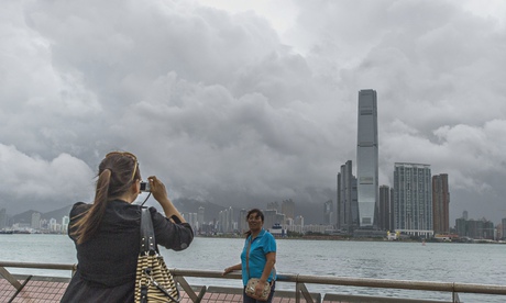
Chinese tourists take pictures in front
Chinese tourists take pictures in front of the Kowloon skyline during Typhoon Kalmaegi. Photograph: Xaume Olleros/AFP/Getty Images
http://www.theguardian.com/world/2014/sep/16/typhoon-kalmaegi-hits-hong-kong

Grand theft summer: Looks like B.C. stole the season

Ontario is looking at frost by the end of a below-seasonal week, but the Prairies and Atlantic Canada have beaten the province to that seasonal milestone by a couple of weeks already.

And it's been dry, very dry. And it'll stay that way for a little while longer, according to Weather Network meteorologist Tyler Hamilton.

"A marine push is likely on Wednesday afternoon, as the offshore upper level low sends a couple short waves into southern B.C., with showers possible along the south coast," he said Tuesday. "There's increasing chance of showers overnight and into Thursday. Generally, 5-8 mm is forecasted for Vancouver, with 15-20 mm for the eastern Fraser Valley."

Temperature-wise, it'll be a couple degrees lower, but then Hamilton says there may be more heat in store for the weekend.

"Another huge ridge looks probable Saturday/Sunday, and Sunday evening could feature 30oC temperatures in southern B.C.," he said. "Incredible warmth is possible.

And it's been like this most of the summer. In fact, the B.C. southern Interior has consistently been the hottest place in Canada, with numerous days above 30oC, and even a couple of days of forty-degree temperatures for a handful of communities.

http://www.theweathernetwork.com/news/articles/grand-theft-summer-looks-like-bc-stole-the-season/35991/

Late summer weather returns to southern Ontario ahead of Fall Equinox

Thursday will bring the coldest daytime temperatures of the week with highs struggling to reach the mid-teens, which is more typical of mid-October.

Friday morning will be the coldest morning that we have since last spring as parts of southern

Ontario, including the outskirts of the Greater Toronto Area (GTA) will see frost.
While temperatures will stay well above freezing in the more urban regions of the GTA and along the shorelines of the Great Lakes, much of cottage country and eastern Ontario will drop to near or just below freezing. The Kitchener Waterloo region will also be cold enough for patchy frost.

http://www.theweathernetwork.com/news/articles/late-summer-weather-returns-to-southern-ontario-for-the-weekend-/35982/